 Official Name:
ANDREW WARBURTON MEMORIAL PARK
Formerly: Homeside Park
Location: At the intersection of Tragina Ave. N. and Britannia Ave., near Allan Ave. and Cope St. - Ward 4
Survey Description: 199 Tragina Ave.: Reference Plan 62R6210, Parts 4 to 12, Parts 15 to 22, Plan 502, Lots 29 to 36, Plan 113, Lots 333 to 337; 221 Tragina Ave.: Plan 502, lot 28, Plan 498, Lots 182 to 185, Reference Plan 62R6210, Parts 1, 2 3, 13, and 14; 40 Allan Ave.: Reference Plan 62R6247, Part 1, Plan 498, Lots 136 to 140, part of lot 135
Size: 0.73 hectares (1.80 acres)
Official Naming Date: December 9, 1986
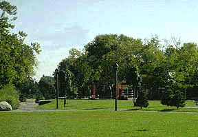
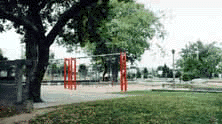
Features: multi-purpose court, playground, wading pool, plazas, benches, shelter, walkway, parking
History
 For many years the north end neighbourhood of Homeside had only 0.4 hectares (1 acre) of park land. As a result, in January 1982, the province and the City approved funding for a neighbourhood renewal program there. Approximately $1 million was approved to buy 23 properties in the area to make Homeside Park.
In 1986, Andrew Warburton (1977-1986), a 9 year old boy from the Homeside area, died tragically while
 on vacation with his family in Nova Scotia. On his way to a lake to go swimming, Andrew got lost in the forest. The next day hundreds of people helped search for him, but could not find him. One week later his body was found under a tree.
Brian Lewis, an insurance broker from Homeside, began a petition to change the name of the Homeside Park to Andrew Warburton Memorial Park. In December 1986, Hamilton City Council approved the petition, which 4,665 people from the Homeside neighbourhood had signed.
References:
1. Corporation of the City of Hamilton, Department of Public Works and Traffic, Parks Division, Park Development Section. Parks Master Plan database, 1996.
2. Hamilton Municipal Documents. Subject: Hamilton Neighbourhoods. Title: Homeside Background Report.
3. The Hamilton Spectator. January 25, 1982.