 Official Name:
CENTRAL PARK
Also Known As: Central Neighbourhood Park
Location: on Bay St. N., north of Cannon St. W., near Sheaffe St., Mulberry St., Railway St., Caroline St. N., Mill St., and Harriet St. - Ward 2
Survey Description: Concession 2, part of Lot 16, Township of Barton, in the City of Hamilton. Part of parcel 95, part of parcel 98, part of Parcel 119.
Size: 2.77 hectares (6.84 acres)
Official Naming Date: January 12, 1988
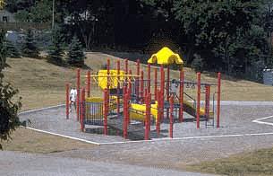
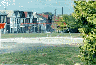
Features: ball diamond with lighting, tennis courts, playground, walkways, benches, wood tables, drinking fountain
History
At the turn of the century, the location of Central Park was called the Caroline Street Gully. This natural valley, once a part of Barton Township, was used as a trash dump and sewer collection site for the local brewery, soap and natural gas works.
In 1976, the City bought the park land from various owners for $800,000, and developed it with money from the Community Services Contribution Programme in 1981. The property was named Central Park, because it is located in the Central neighbourhood. 
In 1992, a committee of Central neighbourhood residents and City Park Development worked together to plan park improvements. The Central neighbourhood approved the planned changes to the park on February 17, 1993. Other improvements are planned for the next several years.
References:
1. Burkholder, Mabel. Our Heritage Scrapbook. vol. 3. p. 45. Special Collections, HPL.
2. Clipping File. Hamilton - Parks - Central Park. Special Collections, HPL.
3. Corporation of the City of Hamilton, Department of Public Works and Traffic, Parks Division, Park Development Section. Parks Master Plan database, 1996.
4. The Hamilton Spectator. July 27, 1883.