 Official Name:
CHEDOKE GOLF COURSE
Also Known As: Chedoke Golf and Ski Centre, Chedoke Park
Location: between Aberdeen Ave. and the Mountain at the Chedoke Expressway, near Studholme Rd., Beddoe Dr., Chedoke Ave., Glenside Ave., Colquhoun Cres., Scenic Dr., Sanatorium Rd., Highway 403 - Ward 1
Survey Description: 565 Aberdeen Ave.: Concession 4, part of Lot 21, Township of Barton, City of Hamilton. Registered Compiled Plan 1479, part of Lots 10 & 11; Registered Plan 62R6546, Part 1; 18 Mountside: Concession 2, part of Lot 57
Size: 93.91 hectares (232.05 acres)
Official Naming Date: November 24, 1987
Features: Martin Golf Course, Beddoe Golf Course, 900 ft. beginner ski slope with T-bar tow, 1,300 ft. intermediate ski slope with T-bar tow, advanced ski slope with chair lift, licensed club house with change rooms, concession stand, ski rental, snow making equipment, walkways, benches, picnic tables, washrooms, drinking fountains
History
Index
Chedoke Golf Course
Chedoke Winter Sport Park
Chedoke Radial Trail
Chedoke Golf Course
The Chedoke Golf Course area was first used as a golf course in 1896, when the private Hamilton Golf and Country Club rented a part of the old Paradise dairy farm for a 9-hole golf course. The Club bought the land in 1906, and added 9 more holes. In 1915, they stopped using this course because of a disagreement over taxes, and moved to another course in Ancaster. The army used the Hamilton course for training during World War I.
In 1921, George C. Martin led a committee representing the Chamber of Commerce, that asked the Parks Board to think about buying the private grounds for a public golf course. The Parks Board was against buying it, but did look into the idea of public golf courses. The City Council also thought the course was not needed, but suggested to the committee, that the golf club could be started on its own. If the golf club proved to be a success, it would be much easier to try and convince the City to buy it later. The Chamber did rent the land for the cost of the property taxes from its owners, still the private golf club in Ancaster. Volunteers were found to look after the grounds, and lockers, tables, chairs, benches, a refrigerator, etc. were donated. W.H. Cooper, who owned the brickfield located in Churchill Park around 1921, built a clubhouse for the price of the building materials.
 The Chamber also organized a campaign beginning December 1, 1921, that suggested that the City buy the golf course. The press and the Trades and Labour Council openly supported the idea. Mr. Martin became the club president, and was so popular and successful, that he was re-elected every year for the next 20 years. After three weeks of the campaign, 600 members had applied to join. The club had 1,043 members by the end of the first year. The club ran a second year to improve its financial situation. When the committee spoke to the Parks Board and City Council a second time in 1924, the club was doing well. The City bought the golf course the same year. Another 11.33 hectares (28 acres) were added to the west side of the course in 1928.
The name Chedoke ("seven oaks" in a Native language) was given for the Chedoke Ravine, which runs through the area. 36 holes of golf are now offered on two courses named after former club presidents, George C. Martin and Harold S. Beddoe. The Martin Course (5,784 yards) is the original par 70 course, bought in 1923 from the Hamilton Golf and Country Club. The land for a second par 72 course was added in 1945. The Beddoe Course (6,084 yards), designed by the Canadian golf course architect, Stanley Thompson, was built in 1947. A new and bigger clubhouse with showers, a lunch counter and lockers was finished in 1952. An extra fairway was added to the Martin Course in July 1958.
In May 1953, a big storm on the Beddoe Course washed out seven bridges, created a trench 8-10 feet wide and 6-8 feet deep, and covered six fairways with stones, logs and other garbage from the Chedoke Radial Trail and Mountain. Damages were set at about $12,500.
In 1956, the inner stone pillars from the Rolph Gates in Dundurn Park were moved to the south-western edge of the golf course. A new wrought iron fence was added next to them, and the parking lot was enlarged in 1957. The pillars were moved back to Dundurn in 1976, when the Rolph Gates were rebuilt at the end of the driveway to the parking lot.
In May 1961, the City bought 27.21 hectares (67.24 acres) of the Chedoke Golf Course for $145,900 to build the Chedoke Expressway. This included 7 hectares (17.32 acres) of the Beddoe Course (the whole tee, fairway and green of the sixth and twelfth holes, and parts of 5 other holes) rebuilt from October to December 1961, and finished in May 1962.
A Golf-A-Thon was held in June 1991 to raise money for improving the course. In July 1995, on a Sunday night, someone set fire to four golf carts fenced into a compound at Chedoke Golf Course. Fire damages came to $25,000.
Chedoke Winter Sport Park
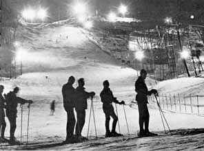
By 1926, tobogganers were already using a specially built toboggan run at Chedoke Golf Course. The idea to use the golf course for skiing and skating too was suggested in 1962 by a group of people who called themselves the Hamilton Winter Sports Research Committee. Through their efforts, and those of other interested people, the Chedoke Winter Sports Park was able to open in January 1964. The first $105,000 was used for a beginner ski slope and tow, and 500 and 600 foot toboggan runs. The intermediate slope was being built in 1964, and opened the next year. The third and final advanced slope opened in 1966. Lifts for all three runs were operating by 1967.
5,000 people attended the first annual Chedoke Winter Carnival held in the park in 1965. Activities included a variety of serious and silly races on skis and snowshoes, a Miss Chedoke Ski Pageant, snowman making contests, and other snowy events. In 1967, everyone at the Carnival received a participation certificate and medal honouring the Canadian Centennial year.
In 1966 Chedoke Winter Sports Park became so popular, that bus service began running from the Canada Westinghouse parking lot to the slopes. Apparently so many people were coming by car to use the park, that the parking lot was full. Cars had been parking on both sides of Studholme Road, blocking traffic.
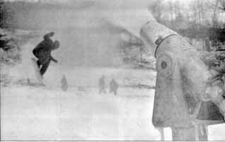
Throughout the 1990's the Winter Park has been having financial problems, losing money almost every season. Many people have complained about the park equipment, which has not been replaced or renewed since it was installed in the 1960's. Many times, City officials have considered closing the park completely, but the public has always stopped this from happening. Hours of operation are now reduced, although people still use it to ski, snowboard and toboggan when it is closed.
Chedoke Winter Sport Park is Canada's biggest city-owned winter recreation area, and the only ski area in Ontario within city limits. The parking lot of the park can be reached by steps from the Upper Paradise Road on the Mountain Brow, as well as the main entrance from Aberdeen Ave.
Chedoke Radial Trail
The Chedoke Radial Trail is built on what was once railway tracks for the Brantford and Hamilton Electric Railway owned by the Cataract Power Light and Traction Company (later Dominion Power and Transmission). This particular railway began service to the neighbouring communities of Ancaster in 1907, and Brantford in 1908.
A 50-minute train ride once took you on a 23-mile trip from the Main and Catherine St. Station, past the Mountain end of Dundurn St., to Brantford through Ancaster, Alberton, Langford and Cainsville. A part of the tracks went west, on the south side and behind the Chedoke Golf Course, and across the Chedoke Ravine. On the way up the mountain, the train passed right through a cut in the rock face, and gave riders a spectacular view of Hamilton and the Dundas Valley.
By 1931, other kinds of transportation had become more popular than the train. On June 30, the train took its last trip to Brantford with the same cars that had been used on the first trip in 1908. The tracks were removed the next year, and the land as far as Ancaster was given to the Parks Board in 1938. The 2.7 km strip became a part of the Bruce Trail.
In May 1953, a big storm caused the Trail to collapse in two places, spilling tons of stones and rocks onto fairways nine and ten of the Beddoe Course at Chedoke Civic Golf Course. These were later repaired.
The City developed the Chedoke Rail Trail for walking and cycling from 1995 to 1996. Half of the money for this development came from the Waterfront Regeneration Trust.
References:
1. Annual Report of the Board of Park Management for the City of Hamilton, 1957.
2. Annual Report of the Board of Park Management for the City of Hamilton, 1961.
3. Annual Report of the Board of Park Management for the City of Hamilton, 1967.
4. Clipping File. Hamilton - Organizations & Societies - Chedoke Civic Golf Club. Special Collections, HPL.
5. Clipping File. Hamilton - Parks - Chedoke Winter Sports Park. Special Collections, HPL.
6. Corporation of the City of Hamilton, Department of Public Works and Traffic, Parks Division, Park Development Section. Parks Master Plan database, 1996.
7. Fires in Hamilton Scrapbook. vol. 13. p. 148.
8. Hamilton Report. Summer 1988. p. 53.
9. Hamilton Spectator - M.J. Campbell Scrapbook. vol. 3. p. 40. Special Collections, HPL.
10. Head-of-the-Lake Historical Society, Hamilton, Ontario. Wentworth Bygones. no. 9. Hamilton: Walsh, 1971. p. 7.
11. Henley, T. Brian. Our Heritage Scrapbook. vol. 6. p. 45-46.