The coast consists of precipitous banks ... the shale was in a state of ignition in many places and the hot sulphureous airs from the land were strongly contrasted with the cold sea-breezes ... the baked clays of yellow, brown, white and red colours caused the place to resemble a brick field or pottery.
J. Richardson, 1826, describing the "Smoking Hills".
THE LAND:
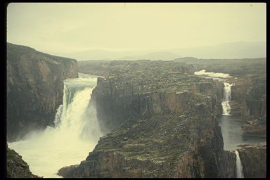
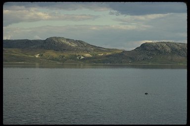
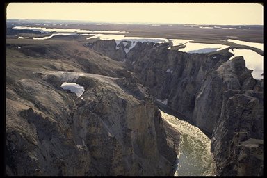
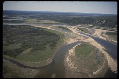
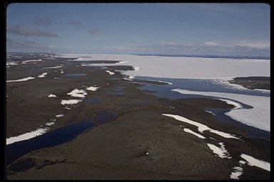
The western part of this region is underlain by sedimentary bedrock in undisturbed horizontal layers creating a landscape of plains, patterned ground and pingos. The eastern part of the region is part of the ancient Canadian Shield. Here the topography is rugged and hilly, with many lakes, large and small. The ice sheets have added the final touches to the landscape - eskers, drumlins, deposits of glacial till and other glacial features. Step-like series of raised cobble beaches and marine clay deposits more than 60 metres above sea level are a testimonial to the combination of higher sea levels in post-glacial times and the re-bounding of the land after being released from the weight of the glaciers. The rivers have cut deep gorges and canyons through the sedimentary bedrock. These have been compared to the canyons of the southwest United States. Wilberforce Falls on the Hood River is one of the most spectacular waterfalls in Canada.
Perhaps the most remarkable feature of this region is the "smoking hills", a site of slow-burning bituminous coal. In this landscape, which resembles paintings of Hell, sulphur fumes have killed off the vegetation, and smoke billows from the cracks in the ash-covered ground.
VEGETATION:
More than 95 percent of this region is tundra - rock barrens where mountain avens and purple saxifrage grow in dense mats; polar deserts where only lichens can thrive; verdant wet sedge meadows; dense carpets of willows, dwarf birch and heath vegetation. An undulating band of stunted, creeping spruce trees interspersed among the heaths and other typical tundra species extends into this region along river valleys, marking the northerly limit of tree growth.
WILDLIFE:
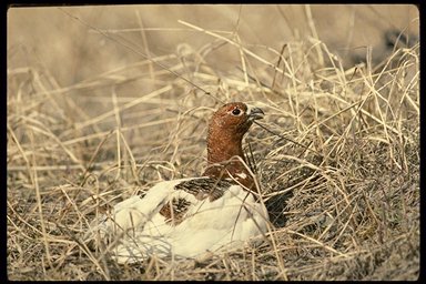
The wildlife of this region features few resident species and many summer migrants. This reflects the difference in the availability of food between the continuous summer sunshine and the long, dark winter.
Two major caribou herds, the Bluenose Herd and the Bathurst Herd, migrate throughout this region. Together they are estimated to number over 500,000 animals. Native peoples in the region still depend on the caribou as they have for thousands of years. There are also significant populations of muskox in the region that are recovering from over-hunting early in the 20th century.
The only remaining nesting ground for the Eskimo curlew, perhaps the rarest bird in Canada, is in this region. In the 1800s it existed in huge flocks, but by 1900 it was hovering on the brink of extinction, a victim of over-hunting.
STATUS OF NATIONAL PARKS:
Parks Canada is working with local residents to establish a national park in the Melville Hills area. In 1989, the Inuvialuit expressed strong interest in establishing a national park in this area to protect the Bluenose caribou herd's calving grounds. Also included within the park study area are such features as the spectacular Hornaday River Canyon, Bluenose Lake and abundant wildlife, including caribou, muskox, grizzly bear and wolf.
There are three land claim agreements which affect the area. Within the Inuvialuit Settlement Region, negotiations are well advanced toward a new park agreement to be signed by Canada, the Inuvialuit and the Government of the Northwest Territories. The Inuvialuit Settlement Region portion includes about 58 percent of the proposed national park and is often referred to as "Tuktut Nogait." Within Nunavut, consultations with Inuit are underway. The Nunavut portion includes about 36 percent of the proposed national park. Within the Sahtu Dene and Métis claim area, consultations are also in progress. The Sahtu portion includes about 6 percent of the proposed park.
Establishment of a national park in this area will require the support and co-operation of the residents of Paulatuk and Coppermine, as well as Inuvialuit, Inuit, Dene and Métis, and the Government of the Northwest Territories.
The following table summarizes the status of system planning for each step towards establishing a new national park in this natural region.
| Steps in the Park Establishment Process | Status |
| Representative Natural Areas Identified | done |
| Potential Park Area Selected | done |
| Park Feasibility Assessed | complete for Inuvialuit component |
| Park Agreement Signed | 0 |
| Scheduled Under the National Parks Act | 0 |