Natural Region 17: Northwestern Boreal Uplands
Not Represented; lands are reserved for a national park on the East Arm of Great Slave Lake
"LAND OF LITTLE STICKS"
Lakes, lakes, lakes innumerable...The first bay we investigated ... developed into a baffling labyrinth of small enclosures and twisting points, islands and channels, hills, knolls, promontories, and even lakelets within lakes. God help the man who gets off the route in this country! Nothing - nothing to go by ... just thousands and thousands of caribou trails.
from the journals of P.G. Downes, on a trip from Reindeer Lake to Nueltin Lake in1939.
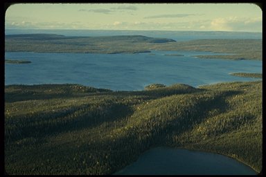
Great Slave Lake
THE LAND:
Ridge after low ridge of granite or gneiss, innumerable interlocking lakes and tumbling rivers, endless spruce forests - the edge of the Canadian Shield marks the western boundary of this region. Here the region abuts onto the great Shield-edge lakes - Great Bear, Great Slave, Athabasca, Wollaston, Reindeer, South Indian - famous for their interlocking convolutions of islands and bays.
The continental ice sheets have left their footprints on the entire region in the form of glacier-scoured lake-filled basins and large expanses of exposed bedrock smoothed and scoured by the passing glaciers. Erratics, boulders left behind by the melting of the glaciers, are sprinkled liberally over the land, and massive eskers, up to 75 metres high, slither indiscriminately across lakes and over the land for tens of kilometres. Glacial erosion and deposition have left an intricate maze of labyrinthine lakes connected by short sections of rapid-strewn rivers.
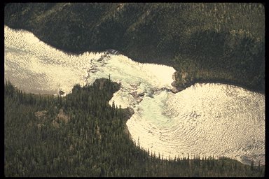
Lockhart River
VEGETATION:
This is a region of spruce forests. In the more temperate parts of the region, the shores of the lakes and rivers are heavily treed with dense forests of black spruce, white spruce and white birch. A closed-canopy forest of spruce and jack pine, with an understory of feather moss, lichens, blueberries and cranberries, covers the southern part of the region. Toward the north are open woodlands of black spruce spaced 5-10 metres apart and rarely reaching 15 metres in height. A mat of lichens up to 15 centimetres thick carpets the ground between the trees. On the northern fringe of the region, even more open stands of stunted black spruce and tamarack with a ground cover of dwarf tundra vegetation form a transition to the barrenlands.
WILDLIFE:
This is a region rich in wildlife. Vast herds of caribou winter here in the spruce forests, some staying all year round. In late October, after the rutting season, the great bands of caribou mass up on the edge of the woods and spend the harshest winter months in the spruce and pine forests. The females start to work their way north again in February or March, bearing their young on the barren-grounds in June. By July, they are on the move again toward the forests.
The region has long been famous as a source of furs - beaver, muskrat, lynx, wolf, red fox, wolverine, martin, mink, otter. Moose and black bear are also abundant. Lake trout, white fish and huge northern pike thrive in the cold, nutrient-poor lakes and rivers.
STATUS OF NATIONAL PARKS:
For more than 20 years, an area known as the East Arm of Great Slave Lake has been considered for a national park. In 1970, 7150 square kilometres of land in this area were withdrawn under the Territorial Lands Act for national park purposes. This is a spectacular landscape - an immense archipelago of islands in Great Slave Lake, long fault-block escarpments, gorges and waterfalls, and much more.
Progress on this national park proposal has been stalled for some time. The Aboriginal people who will be most affected by the proposal are concerned about the effects of a national park on their traditional use of the land and on their lifestyle. There is no local consensus on whether a park would be appropriate.
The federal government has assured the people of Lutselk'e that a park will not be established without their agreement. Parks Canada expects to resume discussion on this park proposal with the people of Lutselk'e at the appropriate time in their Treaty 8 land entitlement negotiations. The support of the Government of the Northwest Territories is also required.
Other possible representative natural areas include Conjuror Bay on Great Bear Lake and Athabasca North Shore.
The following table summarizes the status of system planning for each step toward establishing a new national park in this natural region.
| Steps in the Park Establishment Process | Status |
| Representative Natural Areas Identified | done |
| Potential Park Areas Selected | done |
| Park Feasibility Assessed | stalled |
| Park Agreement Signed | 0 |
| Scheduled Under the National Park Act | 0 |
HOME