THE OTHER BAY OF GIANT TIDES
The deer [caribou] are the property of a spirit. The spirit sends them every year to
the barren ground to feed in the summer and in the fall he drives them back east,
to put them in a mountain which is so high that no Indian can go to the top of it,
where they remain all winter, sheltered from the weather. The mountain is
guarded by ants as large as frogs, by frogs as large as foxes, by foxes as large
as wolves.... Should this spirit find the pelt of a deer ... left to rot, he would be so
angry that he would search the whole country and not leave one deer for the
Indian who left the skin in such a manner....
As told to James Clouston, explorer and fur trader, by his guide
in 1820.
THE LAND:
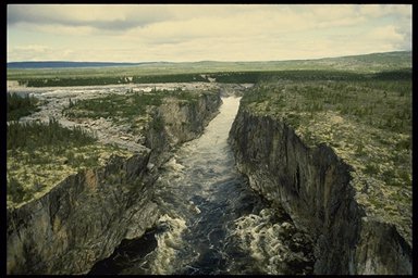
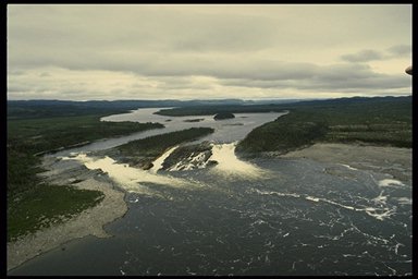
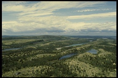
A saucer-shaped depression, in places a featureless plain, this region is bordered on the west by the rugged Labrador Hills and on the east by the ancient granite hills of the George Plateau. The unyielding bedrock of the Canadian Shield underlies this area, though it is often hidden under glacial deposits and features such as drumlins and moraines. Permafrost is present throughout much of the region. Broad boulder mudflats fringe the coast of Ungava Bay, which boasts some of the world's highest tides (as great as 18 metres) and strongest tidal currents.
VEGETATION:
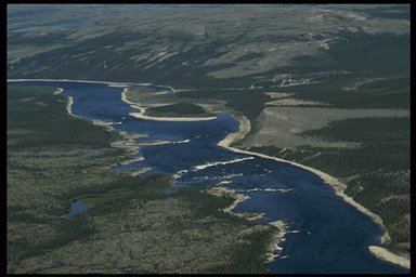
The vegetation of this region is transitional between tundra and taiga. Most of the region south of Ungava Bay is covered by open stands of black spruce interspersed with dwarf birch, northern Labrador tea and lichens, with shrubs accounting for about 50 percent of the ground cover. Denser forests grow along the major river valleys. These trees are surprisingly large for being so close to the tree line. A larch over 23 metres high on the Koksoak River and many black spruce over 17 metres have been recorded.
Along the coast of Ungava Bay is a nearly continuous cover of dwarf tundra vegetation less than 30 centimetres tall. Paralleling this zone is a narrow band of vegetation characterized by very open stands of stunted black spruce and tamarack. Tundra vegetation covers the ground between the trees. Many of the trees are so stunted that they appear more like recumbent shrubs. A few vertical branches a metre or more in height, bare except for a few living sprigs at the tip, remind one that these are trees. Vast areas of bogs and fens occur throughout the region. Sedges, sphagnum, northern Labrador tea and cotton grass are typical species growing on poorly drained areas.
WILDLIFE:
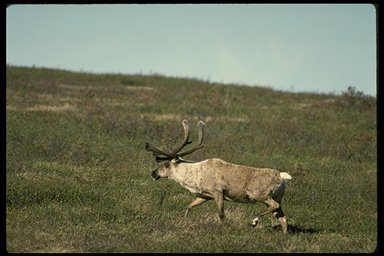
The numbers of caribou have increased in recent years to over 700,000 animals, making their home for at least part of the year in this region, bearing their young on calving grounds on the tundra plateaus near the Ford River, migrating in late June to the Labrador coast in order to escape the hordes of biting insects, and returning to the region's interior in August to winter.
Other characteristic wildlife species include moose, black bear, beaver, snowshoe hare and arctic fox. Arctic char are abundant in all large rivers in the region, along with Atlantic salmon. The mud flats on Ungava Bay provide important nesting and moulting habitat for snow geese, Canada geese and other waterfowl. Important murre colonies are located on Akpatok Island, and the waters near the island are important for seals, walrus and beluga whales.
STATUS OF NATIONAL PARKS:
No national parks have yet been established in this region. Completing a regional analysis to identify representative natural areas is the first step. A study completed in 1995 suggested two areas that merit further consideration: George River and Caniapiscau River. More detailed studies to confirm which of these best represents the region will be the next step.
Both areas are within the area covered by the James Bay and Northern Quebec Agreements (1975-1980). Other factors that could influence park establishment include the hydro-electric power potential of these rivers and the high mineral potential of the Canadian Shield that underlies this region. Iron ore and nickel deposits have been discovered in the Labrador Hills in the western part of the region, and have been developed in the vicinity of Schefferville.
The establishment of a new national park in this natural region will require the concurrence of the Government of Quebec, local Aboriginal people and Makavik Corporation.
The following table summarizes the status of system planning for each step toward establishing a new national park in this natural region.
| Steps in the Park Establishment Process. | Status |
| Representative Natural Areas Identified: | in progress |
| Potential Park Area Selected: | 0 |
| Park Feasibility Assessed: | 0 |
| Park Agreement Signed: | 0 |
| Scheduled Under the National Parks Act : | 0 |