THE UNKNOWN EASTERN MOUNTAINS
Breath-taking fiords, jagged peaks rising abruptly from a frigid sea, icebergs,
polar bears, glaciers .... some of the most spectacular coastscapes in the world
are found in this natural region - unknown to all but the Inuit.
This region contains two distinct, contrasting landscapes: the George Plateau and the spectacular Torngat Mountains.
The George Plateau is a level bedrock plain cut by deep river valleys sloping gently to Ungava Bay. The effects of glaciation are ubiquitous: drumlin fields, kame terraces (ridges of water-born sediments deposited by melting glaciers), erratics and eskers that snake over the plateau.
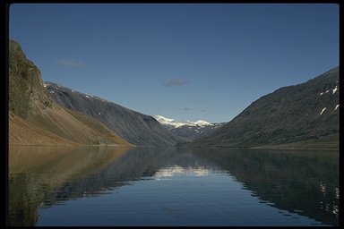
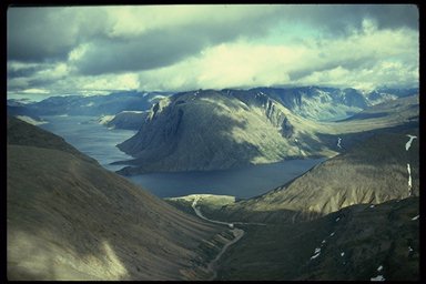
The Torngat Mountains, among the highest, most rugged mountains in eastern North America and one of the world's most beautiful wild coastlines, provide a spectacular counterpoint to the gentle George Plateau.
VEGETATION:
Forest-tundra, characterized by open stands of black spruce and tamarack with an understory of low-lying arctic shrubs, dominates the southern part of the region. As one moves north and climbs higher, the vegetation becomes sparse, consisting mainly of lichens, mosses, sedges, grasses and hardy arctic flowers. Shrubs such as willow and alder are limited to sheltered areas. Rock deserts with little vegetation other than lichens and a few low-lying hardy forbs cover large areas.
WILDLIFE:
Typical mammals include caribou, black bear, red fox, arctic fox, snowshoe hare, wolf, and muskrat. The George River caribou herd, the world's largest, estimated at 700 000 animals, ranges through much of the region. Polar bears patrol the coast, although they are much less common than in the past. Seabirds such as puffins, murres, razorbills and others frequent the rocky islands offshore. Whales - killer, fin, humpback, minke and blue - harbour and ringed seals and the occasional walrus frequent the coast.
STATUS OF NATIONAL PARKS
No national park has yet been established in this region. Interest in a national park in the Torngat Mountains dates back to the early 1970s, when research identified it as a natural area of Canadian significance. Public consultations in the late 1970s concluded that, although there was strong public interest in a national park, further discussions should be put on hold until the Labrador Inuit could deal with the park proposal in the context of their land claims negotiations.
In 1992, the Governments of Canada and Newfoundland and Labrador, and the Labrador Inuit Association, began a joint feasibility assessment to determine whether or not it is feasible to establish a national park in the Torngat Mountains. The consultations are now complete and have demonstrated that a national park has widespread support. The next step will be to negotiate a federal-provincial park establishment agreement.
The Torngat Mountain area is one of the most dramatic landscapes in eastern North America. Fiords slash inland 30-80 kilometres. Cliffs up to 900 metres high rise abruptly from the sea. Icebergs, set adrift two years earlier in Greenland, float by. Inland, the Torngat Mountains, lonely and austere, rip the sky, their sharp peaks reaching elevations of over 1500 metres. These mountains resemble the western ranges in their ruggedness and scale. Broad U-shaped glacier-carved valleys, cirque lakes, glaciers, precipitous waterfalls - all these features are found in this mountainous region.
The establishment of a new national park in this natural region will be done in partnership with the Government of Newfoundland and Labrador and Inuit.
The following table summarizes the status of system planning for each step toward establishing a new national park in this natural region.
| Steps in the Park Establishment Process. | Status |
| Representative Natural Areas Identified: | done |
| Potential Park Area Selected: | done |
| Park Feasibility Assessed: | done |
| Park Agreement Signed: | 0 |
| Scheduled Under the National Parks Act : | 0 |