"At Arnall's Creek they found a flat marsh-grass quite free from forest trees whichwere then universal above the water's edge of Lake Ontario. Here they pitched their tents, the creek and lake forming two sides of a triangle for defence from wolves... Salmon would run in November, and the winter supply of fish secured from the creek.... "
From an account of the first settlers where Toronto now stands.
This natural region comprises three widely separated units linked by the unfolded sedimentary bedrock that underlies them. Although each unit shares a common geological origin, the geographical distances between them and the disparity in intensity of land use and population density produces a lack of uniformity with respect to flora and fauna and the impact of human activities on the land. The western and central units are among the most human-altered regions of Canada, containing about half the population of Canada; the eastern unit is largely unsettled.
The Niagara Escarpment, a line of cliffs and bluffs up to 300 metres high snaking across the entire western unit from Georgian Bay to the Niagara River, is the most prominent landform in a region of gentle unspectacular relief. The Niagara River cuts through the escarpment at Niagara Falls, one of the most outstanding examples of a falls and gorge in Canada, and certainly the most photographed.
The story of the most recent glaciation is written heavily on the region. Large drumlin fields, boulder-studded moraines and thick deposits of glacial till (such as the Scarborough Bluffs near Toronto) dominate the topography of the region.
Of all the natural regions in Canada, this region encompasses the greatest biodiversity. Five biogeographic zones are found in this region: Carolinian forest, deciduous forest and mixed wood forest in the western and central units; mid-boreal and high-boreal forests in the eastern unit.
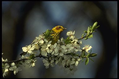
The Carolinean zone, restricted in Canada to the western unit of Region 29, is characterized by flora and fauna whose ranges extend far to the south. The most diverse flora and fauna in Canada are found here.
Although the vegetation is typified by a broadleaf forest of sugar maple, American beech, basswood, white oak, red oak, shagbark hickory, black walnut and butternut, farm fields and man-altered sites are the norm today. Wildlife that thrives in this zone today must be able to take advantage of agricultural crops and suburban habitats. Many common species, such as white-tailed deer, grey squirrel, coyote, starling, house sparrow and ringbilled gull, are recent arrivals to this region. Reptiles include several endangered species (eastern spiny soft-shelled turtle, Blanding's turtle, box turtle, and fox snake, among others) and eastern Canada's only lizard, the five-lined skink.
The climax forest in the deciduous forest zone is dominated by sugar maple and American beech, with hemlock dominant on shady north-facing slopes. White pine, red pine and red oak dominate the dry ridge tops. In the mixed wood forest zone, undisturbed sites consist of sugar maple, yellow birch, eastern hemlock and white pine. Boreal species such as white spruce, black spruce and balsam fir dominate in cool, damp habitats. Moose, wolf, snowshoe hare, martin, spruce grouse and other boreal species intermix with species more typical of southern areas such as the cardinal, white-tailed deer and raccoon.
The eastern unit is characterized by boreal forests of black spruce, jack pine, balsam fir and white birch. Wildlife is boreal: wolf, caribou, lynx, martin, spruce grouse, snowshoe hare. Thousands of snow geese congregate on the tidal flats of Cap Tourmente National Wildlife Area on the shore of the St. Lawrence Estuary during migration.
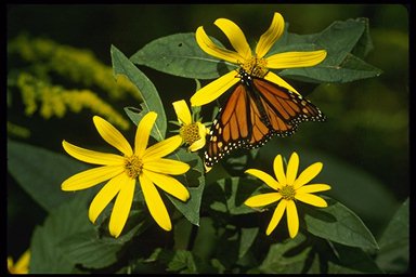
STATUS OF NATIONAL PARKSThree national parks and one national park reserve represent this region. Point Pelee National Park (15 km2), a Ramsar site (wetland of international significance), is renowned as Canada's finest bird-watching site. A sandspit at the southernmost tip of Canada's mainland, Point Pelee is a unique blend of marsh, forest, fields and beach, which combined with its southern extension into Lake Erie, attracts thousands of birds and monarch butterflies on their biannual migrations. The forests of Point Pelee are jungle-like in appearance and harbour an unusually large variety of trees typical of the Carolinean zone. Point Pelee was established in 1918 from Naval Reserve lands after resolutions were submitted to the federal government recommending the preservation of Point Pelee as a wildlife sanctuary.
Bruce Peninsula National Park is the subject of a 1987 federal-provincial agreement with the Government of Ontario that involved the transfer of Cypress Lake Provincial Park and the acquisition of private lands on a "willing buyer-willing seller" basis. The area is a spectacular yet fragile land of rare orchids, limestone cliffs, ancient forest and intricate underground drainage. The popular Bruce Trail hugs the edge of the Niagara Escarpment as it passes through the park to its northern terminus in Tobermory. Together, Bruce Peninsula National Park and Fathom Five National Marine Park form the Core Area of the Niagara Escarpment World Biosphere Reserve. This park will be proclaimed under the National Parks Act once all lands within the park boundary are formally transferred to the Crown, and any outstanding land claims are settled. Since 1994 the park has acquired approximately 2,000 acres from private land holdings.
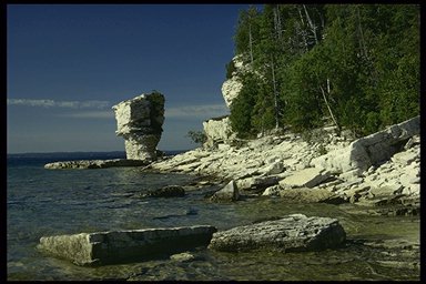
Fathom Five National Marine Park is Canada's first marine park - a diver's mecca where transparent waters and more than 20 shipwrecks beckon intrepid divers. The park consists of the water and 20 islands at the tip of the Bruce Peninsula, and these islands add to the representation of this natural region. Flowerpot Island, the most famous of these islands, (formerly part of Georgian Bay Islands National Park), is named for unusual "flowerpot" rock formations, the result of receding water levels and constant wave action which have eroded the soft limestone bedrock. Similar to the situation with Bruce Peninsula National Park, there are still some private landholdings within the park boundaries that will be acquired on a "willing seller-willing buyer" basis before it will be proclaimed under legislation.
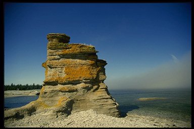
Oddly shaped rock pillars sculpted by wind and sea create the unique island-scape of Mingan Archipelago National Park Reserve (151 km2). Puffins and other seabirds nest on these limestone islands in the Gulf of St. Lawrence, while porpoises, seals and whales feed in the fertile waters offshore. Mingan was set aside as a national park reserve in 1984, pending the resolution of the comprehensive land claims of the Atikamekw and the Montagnais.