COUNTRY OF THE CARIBOU
A land richer in wildlife, in variety of landscape and vegetation, and in
archaeological value than any other in the Canadian Arctic. Here high mountains,
spruce forests, tundra, wide 'flats' of lakes and ponds, majestic valleys ... come
together to form the living fabric of the arctic wilderness...
Dr. George Calef
Wildlife Biologist, Canadian Wildlife Service
THE LAND:
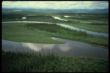
Walking from north to south, the Northern Yukon divides into three landscapes: the rounded Richardson and British Mountains, the vast interior plains of the Old Crow Flats and the rolling Ogilvie Mountains. The Flats are covered with hundreds of rectangular lakes and meandering streams and rivers - a jigsaw water-maze.
Most of this region was bypassed by the Pleistocene glaciers. Vast sweeping pediments smooth the river valleys and isolated hills of frost-shattered rocks called tors, among other testimonials to the absence of glaciation, give the region a unique appearance.
Many palaeotological and archaeological sites have been found. These include some of the best-preserved assemblages of Pleistocene fauna and evidence of human occupation in the Beringia Region that dates from 20 - 40,000 years B.P..

Tundra blankets much of the region - alpine, moist or wet. In the mountains and foothills, alpine tundra patterns the slopes in patches and stripes. Lichens and plants that grow as cushions or mats such as mountain avens, alpine bearberry, moss campion, woolly lousewort and purple saxifrage predominate. At lower elevations, moist tundra colours the land in the rich shades of golf greens. Cottongrass, the dominant plant, forms tussocks, making walking an ankle-twisting agony and quickly dispells any further comparisons to golf greens. A dense, waist-high jungle of willows grows along the rivers.
The interior plain supports open stands of stunted white or black spruce, interspersed with patches of tundra and rock barrens. The most northerly tongue of forest (white spruce) in Canada is found in this region along the valley of the Firth River. In the valleys in the southern part of the region, there are extensive stands of boreal forest.
WILDLIFE:
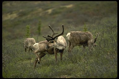
The large Porcupine Caribou Herd, estimated at about 160,000 animals, migrates through this region and into Alaska, wintering in the south and calving on the coastal plain. Moose are abundant in the forests of the Old Crow Flats and muskox have been reintroduced on the open tundra. All three species of bears - grizzly, black and polar - inhabit this region. One of the largest and most concentrated populations of grizzly bears left in the world is found here. Other wildlife includes arctic and red fox, arctic ground squirrel, arctic and snowshoe hare, lynx, wolf, wolverine and muskrat. The Old Crow Flats is renowned for its abundance of muskrats.
STATUS OF NATIONAL PARKS:
Ivvavik National Park (10 168 km2) and Vuntut National Park (4,345 km2) represent this natural region. Part of Ivvavik, the coastal plain portion, extends into the MacKenzie Delta Natural Region (Region 10). These two parks were initially both part of one national park proposal, first advanced in 1978, but were established as separate national parks at different times because they fall into two Aboriginal land claim areas. Planning and management of the two parks are coordinated to the greatest extent possible.
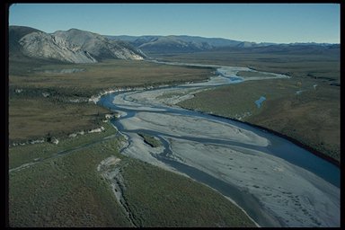
High mountains, broad river valleys, endless tundra and the Arctic seacoast come together within Ivvavik National Park to create a wilderness paradise. The Firth River is the centrepiece of the park, renowned for its beauty, white water rafting, archeological sites, and wildlife. The park includes part of the British Mountains, the only extensive non-glaciated mountain range in Canada. These are rounded treeless mountains cut by smooth sweeping river valleys. The tree line - the limit beyond which trees do not grow higher than two metres - runs through this section of the park, which also harbours Canada's most northerly populations of moose and Dall's sheep.
Ivvavik was established in 1984 through agreement between the Inuvialuit of the Western Arctic and the Government of Canada. Initially known as Northern Yukon National Park, the park was given an Inuvialuit name in 1992. It is Canada's first national park established through a native land claim settlement.
Vuntut National Park was established through settlement of the Vuntut Gwitchin First Nation Final Agreement, one of the Council for Yukon Indians comprehensive land claims, and scheduled under the National Parks Act in 1995. It includes a portion of the Old Crow Flats and represents the interior plain themes of the natural region. Part of the park is designated a Ramsar Site, a wetland of international importance.