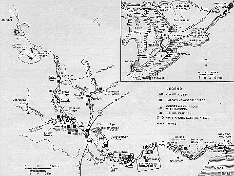
THE GRAND RIVER
ONTARIO
The Grand River flows through the heartland of southern Ontario. Meandering by farms, towns and cities, winding through marshes and forests, it is the common thread that links a harmonious blend of natural and cultural landscapes. Few rivers have seen as much of the flow of Canadian history as the Grand. Native cultures flourished in the watershed for more than 10,000 years. The last three centuries brought successive waves of settlers - United Empire Loyalists, including Mohawks from the United States, Germans, Ukrainians, Mennonites, Scots, Irish and English seeking land, peace and freedom. Together, they looked to the river, and their mosaic of cultures reshaped the valley.
Much of the Grand 's charm is the aura of history that still clings to its banks. The riverfront in rural and urban areas retains much of its early architectural flavour. Many 19th-century mills, foundries, factories and engineering works still stand.

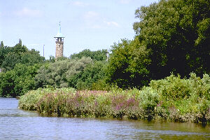
"Living Levee" at Cambridge
Although the watershed has been much altered, almost a fifth remains in a natural state. The Grand River Forest, with its rare Carolinian species, lines the shore along much of its lower stretches. Broad marshes are found at the headwaters and southernmost reaches. An extensive network of riverside trails, one of the world's largest potholes, and the turbulent flow at Elora Gorge all draw their own explorers.
Since the 1930s, careful management has maintained these values even as the urban nature of the watershed grew. The well-preserved evidence of the cultures that were drawn to its fertile valley, the outstanding recreational opportunities it offers, and its scenic beauty, led to the inclusion of the Grand River and its tributaries, the Nith, Conestogo, Speed and Eramosa, in the Canadian Heritage Rivers System on February 20, 1990.
GEOGRAPHY
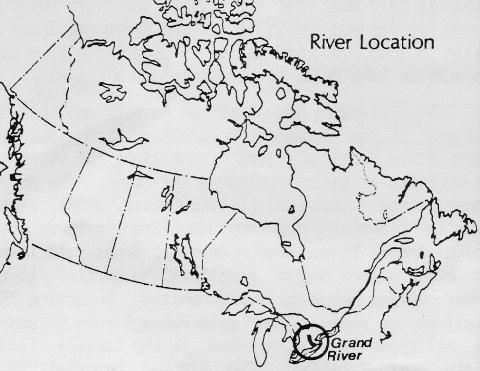
From its source near the village of Dundalk just south of Georgian Bay, the Grand River winds 290 km to Lake Erie, dropping 352 m along the way. Together with its major tributaries, it drains 6965 km2, the largest watershed in southern Ontario. Pastoral vistas are common along the river, since 78% of the watershed is farmland. Rich wetlands, like Luther Marsh in its northern reaches, give way to fast water: at Elora, the river tumbles over a 15 m waterfall and rushes through a spectacular gorge between 25 m limestone walls. Near the twin cities of Kitchener-Waterloo, the Grand cuts across rich farmlands. Further south at Cambridge - which encompasses the former towns of Galt, Preston and Hespeler - the river slides through gravel moraines. The course from Cambridge to Paris is bordered in an almost unbroken stretch by Carolinian Forest. From Cayuga, the Grand flows peacefully, rimmed by broad marshes to its mouth.
HISTORY
Native cultures have long prospered along the Grand. More than 800 known archaeological sites bear evidence of their occupation. Paleo-Indian peoples hunted mastadon and bison here 7,000 - 11,000 years ego. Other hunting cultures followed. By 900 A.D., the Woodlands People were growing corn, beans and squash .
When the French explorers and Jesuit missionaries arrived in the early 1600s, the Neutrals and later the Iroquois held sway over the river. The first European known to descend the river was the famous explorer La Salle in 1669, who used the river as a route from Lake Ontario to Lake Erie, by passing Niagara Falls.
In 1784, following the American Revolution, the Six Nations of the Iroquois Confederacy from Upper New York State received a land grant along the Grand in recognition of their loyaltey to the Crown. The Mohawk Chapel, now a national historic site, still stands near the river crossing they named Brant's Ford, after their famous leader Joseph Brant. Brant sold leases to other United Empire Loyalists who settled in the lower valley below Paris. Mennonites, following "The Trail of the Black Walnut" from Pennsylvania in search of religious freedom, settled in the fertile floodplain near Waterloo. The Pioneer Memorial Tower erected near Doon in 1925 commemorates their arrival. Industrious Scots settled in the Elora, Cambridge, and Fergus areas in the early 1800s.
Doon Pioneer Tower
Communities in the Grand Watershed still reflect their past. In the upper reaches, many rural homes are constructed in natural fieldstone in shades of purple, rose and blue, while the cobblestone buildings of Paris are unmistakable. Towns like Elora, Fergus, Cambridge and Brantford have converted early industrial buildings into markets and restaurants. Thirty-five buildings, from flour and textile mills to foundries and distilleries, have special heritage designation and appear much as they did during their 19th-century heyday. Other sites mark major technological inventions, such as Alexander Graham Bell' s homestead in Brantford, the Joseph Emm Seagram distillery in Waterloo, and the E.W.B. Snider's rolling mill at St. Jacobs.
Many early engineering works built to control the river's fluctuating water levels still stand. The Shand Dam, built in 1942 north of Fergus, is Canada' s first dam built primarily for water conservation. The "Living Levee" in Cambridge, built for flood protection, has become a community focal point. From Brantford to Lake Erie, old locks and channels serve as reminders of the Grand River Navigation Company's canal system linking communities on the Grand with Lake Erie, the Welland Canal and the world. Ghost towns such as Indiana mark the path of the canal.
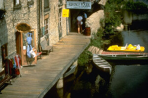
Vintage Building in Elora
NATURAL HERITAGE
Despite sweeping changes to the Grand watershed, the area has a long history of concerned management. Of special note is the Grand River Conservation Authority (GRCA), formed in 1966 through an amalgamation of the Grand River Conservation Commission (1938) and the Grand Valley Conservation Authority (1948) to manage natural resources on a watershed basis. Many GRCA Conservation Areas preserve important natural and recreational areas. Five areas of the Grand stand out for their significant natural values:
- Luther Marsh encompasses a 4000-ha marsh and open water area, a 500-ha acidic fen and upland and lowland forests. A dam built in the 1950s created the marsh, providing ideal nesting habitat for birds such as great blue heron, osprey, rednecked grebe, least bittern and Wilson's phalarope.
- The Grand River Marshes at Dunnville harbour abundant wildlife, and provide important spawning and rearing sites for fish, such as largemouth bass, northern pike, crappie, and yellow perch.
- The Grand River Forest includes extensive uplands and swamp forest, bogs, fens, oak savannah and prairie remnants. This is one of the last remaining Carolinian forests in Canada and includes southern species such as sycamore, sassafras, chinquapin oak, pignut hickory and hackberry.
- At Elora Gorge, the Grand River tumbles over a waterfall, then winds for over 2 km between sheer walls of limestone. A short distance from the waterfall, Irvine Creek, which flows through an equally impressive gorge, meets the Grand.
- During the last Ice Age, swirling rocks in a glacial meltwater stream eroded not only the largrest concentration of potholes (about 300) in Ontario, but also the Devil's Well, which may be the world's largest pothole (5-6 m wide and more that 13 m deep). Much of this unique site is protected within the Rockwood Conservation Area on the Eramosa River.
RECREATION
Many opportunities for camping, fishing, boating, picnicking, hiking, swimming, nature appreciation and environmental education are found at the GRCA'S 37 Conservation Areas, and at many other sites.
River Touring: The Grand is an ideal river for day trips by canoe or kayak. The most consistent water flow is south of Elora. Only a few short portages interrupt the route to Lake Erie. The most popular canoeing day trip is from Cambridge to Paris. The river winds past high bluffs, wide floodplains and the Grand River Forest. In spring, the stretch below Elora Gorge is a favourite with white water paddlers.
Fishing and Hunting: Carp, bullhead, sunfish, rock bass, white sucker and yellow perch are found throughout the river. Sought-after game fish include smallmouth and largemouth bass, crappie, pike, walleye, and salmon, with rainbow and brown trout stocked by the GRCA in some sites. Waterfowl are hunted in the Luther and Dunnville marshes, and small game and deer may be hunted in several designated areas.
Trail and Corridors: The Grand's network of hiking trails is unsurpassed in Ontario. The long and varied Grand Valley Trail offers spectacular river views, but also winds onto the main streets of historic towns. It links to the valley's Avon Trail and Guelph-Speed Trail, and with the Bruce Trail to the east. The Avon Trail joins the Thames Valley Trail to the west. Shorter trails for hiking, cross-country skiing, horseback riding, cycling and snowmobiling join the main trails.
Human Heritage Appreciation: People of the Grand watershed are visibly proud of their history and have carefully conserved sites as varied as the West Montrose Covered Bridge south of Elora and Woodside, the 19th-century boyhood home of former Prime Minister Mackenzie King, in Kitchener, now a National Historic Park. Most towns offer historic walking tours and Cambridge has an amphitheatre in the ruins of an old textile mill. St. Jacobs' Mennonite Meetingplace reflects its religious heritage. Many communities have festivals that celebrate their ethnic backgrounds, such as the Kitchener-Waterloo OctoberFest and the Fergus Highland Games.
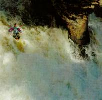
Kayaking on the Grand River
VISITOR INFORMATION
Access: Many of the conservation areas operated by the GRCA provide access to the river for canoeing and water sports. Motorboating is enjoyed on the lower Grand with public launch facilities available at the Byng Island and La Fortune Conservation Areas, as well as at private sites.
Accommodation and Services: The Grand 's cities, towns and villages welcome modern-day explorers with campsites, parks, restaurants, bed and breakfast homes and charming country inns. The Drimmie Mill in Elora, the only 7-storey mill in Ontario, has been converted to a country inn. Campsites are found at 9 GRCA conservation areas, at nearby Rock Point Provincial Park on Lake Erie, and at private campgrounds listed in area tourism booklets.
Maps: Canoeing on the Grand River, published by the GRCA has fold-out topographical maps of the river (1:50 000). National Topographic Series Maps - 30L13, 30M4, 40P1, 40P8, 40P9, 40P16, 41A1, 40P2 & 40P7 - are available in the 1:50 000 scale from the Canada Map Office, 615 Booth Street, Ottawa K1A OE9.
FURTHER INFORMATION
Services, Permits and Regulations : Ontario licenses are required for hunting and fishing. Hunting in the Conestogo Lake area and canoeing the Luther Marsh Wildlife Management Area require permits from the Grand River Conservation Authority.
Tourist Information : Grand River Conservation Authority, 400 Clyde Rd., Box 729, Cambridge, N1R 5W6, 519-621-2761; Kitchener Chamber of Commerce, Box 2367, 67 King St. E., Kitchener, N2H 6L4, 519- 576-5000; Cambridge Visitor and Convention Bureau, 531 KingSt. E.,Cambridge ,N3H 3N4, 519-653-1424; "Festival Country",OntarioTravel , 38 Darling St., Suite 102, Branforde, N3T 6A8, 519-756-3230.
Canadian Heritage Rivers System : Member for Ontario, Canadian Heritage Rivers Board, c/o Director, Parks Branch, Ontario Ministry of Natural Resourses, Whitney Block, Queen's Park, Toronto, M7A 1W3; or Secretary, Canada Heritage Rivers Board, Ottawa, K1A OH3.
Additional Reading :
- Grand River Conservation Foundation . 1989. Grand River Reflections. GRCA. Cambridge.
- Grand River Conservation Authority. 1982 Canoeing on the Grand River. Cambridge.
- Your Valley, Grand River Conservation Authority Newsletter. (available free).
- Grand River Conservation Authority. Grand River Conservation Area Guide Book. Cambridge.
- Voyages: Canada's Heritage Rivers - Lynn E. Noel, editor. Published by Breakwater Books of Newfoundland and sponsored by QLF/Atlantic Centre for the Environment. Newfoundland orders
toll free: l-800-563-3333, Canadian orders and inquiries outside Newfoundland toll free: 1-800-387-0172, U.S. orders and inquiries toll free: 1-800-805-1083. Discount available from Canadian River Management Society, Tel. 819-994-3011.
Written by: Michael Greco with assistance of The Grand River Conservation Authority
Edited by: Michael Greco
Photos Courtesy of The Grand River Conservation Authority and The Canadian Redreational Canoeing Association
Maps Created by: Diamentino Batista
Last Revised:1988