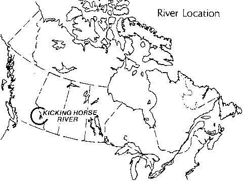
KICKING HORSE RIVER
BRITISH COLUMBIA
Each year, more than a half million people visit Yoho National Park and enjoy panoramic views of
the Yoho and Kicking Horse River Valleys. Many of these visitors enjoy a range of recreational
pursuits such as canoeing and kayaking, backpacking, camping, and, in winter, cross-country skiing,
winter camping, and waterfall ice-climbing. Just outside the park, in the scenic lower Kicking Horse
Canyon, kayakers and white-water rafters challenge spectacular rapids.
The Kicking Horse River valley provides visitors with an exceptional opportunity to discover more
about the natural and historical features and events which shaped much of present-day western
Canada. Draining the glaciers and forests of the Canadian Rocky Mountains on the western slopes
of the Continental Divide, the Kicking Horse is a classic example of a glacier-fed mountain river,
displaying a range of characteristic fluvial and glacial features. The river valley also played a major
role in the exploration and development of the Canadian West. Today it serves as a corridor for both
the Canadian Pacific Railway and the Trans-Canada Highway.
For these reasons, the Kicking Horse River was nominated to the Canadian Heritage Rivers System
by Environment Canada's Parks Service in 1986. With the completion of the Yoho National Park
Management Plan, the Kicking Horse River in Yoho National Park was officially designated in 1989
as a Canadian Heritage River - the only one that flows within the provincial boundaries of British
Columbia.
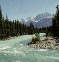
Kicking Horse River Flats near Field, B.C.
GEOGRAPHY
The Yoho river, chief headwater of the Kicking Horse, originates in the Waputik and Wapta
icefields on the west slope of the Continental Divide. Other tributaries flow from the famous Lake
O'Hara area and other timberline valleys, joining their flow to that of the Yoho River at the Meeting
of the Waters, a scenic viewpoint north of Field, B.C.
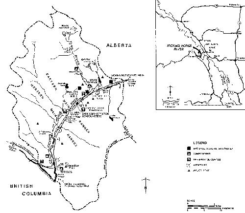
The Kicking Horse flows through the Eastern and Western Main Ranges of the Rocky Mountains,
leaving the park downstream from Wapta Falls to tumble through the spectacular lower Kicking
Horse River Canyon to its confluence with the Columbia River. The section of the river system
designated a Canadian Heritage River consists of the 49 km headwaters section which lies within
Yoho National Park, as well as the 18.5 km Yoho River, the Kicking Horse's primary upstream
tributary.
True to the Indian word "Yoho", used to express amazement or awe by the Cree people, the Kicking
Horse and its tributaries drain a spectacular landscape of massive icefields, mountain peaks ranking
among the highest in the Canadian Rockies, canyons, gorges, cliffs and avalanche slopes. The
Kicking Horse River system is fed by glacial meltwater streams and small timberline lakes. It varies
along its length from turbulent rapids and waterfalls to braided streams meandering through valley flats.
NATURAL HERITAGE
The Kicking Horse courses through one of Canada's outstanding natural heritage river environments,
Yoho National Park. Its watershed contains features which offer evidence of the earth's evolutionary
history over a period of 600 million to 800 million years. Most notable of these features are:
- the Burgess Shale, a geological feature containing internationally significant fossil sites with more than
140 species, dating back 530 million years;
- many of the highest peaks in the Canadian Rocky Mountains' Eastern and Western Main Ranges, 28 of which exceed 2,900 meters in height;
- "U" shaped valleys representing long periods of glacial activity;
- fluvial erosion features such as river terraces, gorges, hoodoos, alluvial fans, outwash plains, and a natural bridge;
- the Wapta and Waputik icefields;
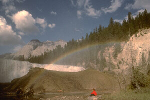
Wapta Falls.
- large waterfalls such as Wapta Falls, 27 meters high and 61 meters across, and the spectacular Takakkaw Falls, dropping 254 meters from the Daly Glacier to the Yoho River;
vegetation representing the four major ecoregions of the Canadian Rockies - Interior Western Hemlock, Montane, Subalpine and Alpine;
- mammals such as grizzly bear, elk, mountain goat, wolverine and porcupine; and,
- bird life which includes the American dipper, harlequin duck, bald eagle, osprey, barred owl, pileated woodpecker and many other mountain species.
HISTORY
As the route chosen for Canada's first transcontinental railway - the Canadian Pacific - and later for
the Trans-Canada Highway, the Kicking Horse River valley is rich in features of national historical
significance. The most important are:
- the Kicking Horse Pass: explored by Sir James Hector of the
Palliser Expedition in 1858 in search of the best transportation route through the Rockies, and later
chosen as the main line route over the Great Divide for the Canadian Pacific Railway;
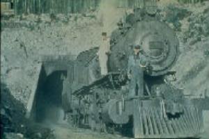
Spiral tunnel in Yoho National Park along the Kicking Horse River, a major Canadian engineering feat
- the 2.5 km "Spiral Tunnels", representing one of the major feats in Canadian engineering history, tunnels that curve around, under and over themselves, dropping in elevation and changing direction - cut through the solid mountain rock early in this century to overcome the valley's steep slopes;
- plaques and monuments featuring the achievements of Canadian scientific explorers, mapmakers and surveyors, including Edouard Gaston Deville who pioneered the use of photogrammetry in mapping the Canadian Rockies at the end of the 19th century;
- a long association with Canadian conservation history, reflected in the establishment of Yoho National Park in 1886, and in the declaration of the park as part of the Canadian Rocky Mountain Parks UNESCO World Heritage Site in 1984.
RECREATIONAL USE
One of the Kicking Horse River valley's attractions is easy access for visitors. Of the 2.5 million travellers who pass through Yoho National Park each year, most confine their visit to the use of viewing areas, picnic facilities and interpretive displays along the Trans-Canada Highway and the Yoho Valley and Emerald Lake roads. A smaller number of visitors, however, take advantage of the wider range of outdoor activities that Yoho National Park, and the Kicking Horse River in particular, have to offer.
Canoeing, Kayaking, and Rafting: Slightly more than 30 km of the river's lower reaches within Yoho
are considered navigable from late June to early August. The river system provides exceptional
opportunities for experienced canoeists and kayakers on water ranging from intermediate difficulty
to very difficult, depending on water levels. It is also one of 7 rivers in British Columbia which has
been designated by the province for use of commercial rafting operators. Because it is a glacier-fed
river, water levels are highly variable, with peak flows during hot periods in summer. Those
interested in a river trip on the Kicking Horse should obtain detailed information from park wardens
or visitor services personnel before starting out, and may want to buy the Kicking Horse River Guide
from The Friends of Yoho sales outlet in the Field Information Centre.
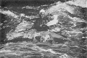
The Kicking Horse River is a favourite among area kayaking enthusiasts.
Hiking: Yoho is a hikers' park, and the trails that probe the headwaters of the Kicking Horse are noted for their beauty. Trails range from short nature walks such as the 1.6 km stroll to Wapta Falls, to extended backpacking routes. There is limited mountain bicycle access into specifically designated backcountry areas.
Camping: Four developed campgrounds are located along the river system - Kicking Horse, Hoodoo
Creek, Chancellor Peak and Takakkaw Falls Campgrounds - providing 285 developed sites.
Camping along backcountry trails is also available at designated primitive campsites. Random
wilderness camping is in a few remote, select areas. Wilderness campers require overnight permits which
may be obtained at the park information centre at Field.
Fishing: Fishing is generally poor, due to the cold, turbid water conditions associated with the swift,
glacially-derived mountain streams. Native bull trout and introduced brook and rainbow trout are
found in the river. A national park fishing permit, available from the park information centre, is
required.
VISITOR INFORMATION
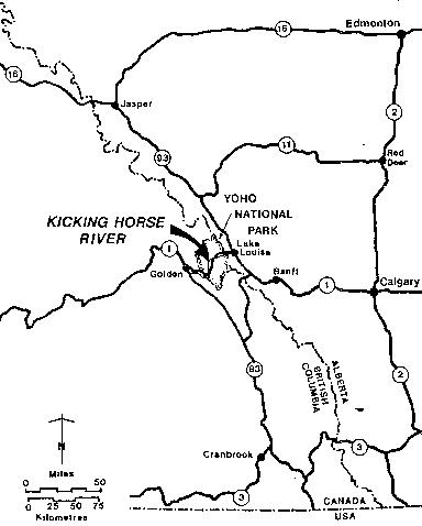
Access: Being near the Trans-Canada Highway, the Kicking Horse River system is easily accessible.
From northern Alberta and British Columbia, the highly scenic Icefields Parkway (Highway 93),
brings visitors 240 km from Jasper to Lake Louise, situated only 12 km east of the river's
headwaters. The area may also be reached by road from Edmonton (483 km) and Calgary (210 km),
and most major centres in British Columbia, including Vancouver, are within a long day's drive.
Several roads and trails, and a number of pull-offs along the Trans-Canada provide direct access to
the Kicking Horse and Yoho rivers themselves. Bus service to Field is also available.
Accommodation and Services: Although Yoho National Park is open year round, many visitor
services, facilities, and interpretive programs are available only during the summer months. Services
and accommodation are provided by the communities adjacent to and within the mountain parks.
Golden and Field in British Columbia and Lake Louise, Banff and Canmore in Alberta are the
primary service centres for visitors to the area. Golden is the preferred staging area for white-water
rafting and kayaking.
Field offers basic services year-round with a service station, groceries, visitor accommodation and
park administration services. Park information is available year-round at the Travel Information
Centres in Field and in Banff. The Tourist Information Centre in Golden is open from mid-April to
mid-September.
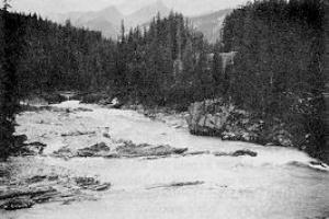
Fast water on the Kicking Horse River.
Within Yoho, West Louise Lodge, located on the Trans-Canada, 12 km east of Field; approved
accommodations and a hostel located in Field; the Emerald Lake Lodge and Conference Centre; and
two backcountry Alpine Club of Canada huts provide accommodation year-round. Lake O'Hara
Lodge, the Twin Falls and Cathedral Mountain chalets, and the Whiskey Jack Hostel are open
seasonally. In all, overnight commercial accommodation for up to 500 visitors is available during
the summer within the park.
Topographic Maps: The Kicking Horse and Yoho Rivers, are covered at the 1:50,000 scale by maps
82N1, 82N2, 82N7, 82N8, 82N9 and 82N10 in the National Topographic Series, and at the
1:250,000 scale by map 82N (Golden). There is also an excellent National Parks map that includes
Yoho, Kooteney and Banff National Parks. Maps may be obtained from the Canada Map Office, 615
Booth Street, Ottawa, K1A 0E9, or from The Friends of Yoho, Box 100, Field, B.C., V0A lG0.
TOURIST INFORMATION
Kicking Horse River - Park Services, Permits and Regulations: Superintendent, Yoho National Park,
Box 99, Field, British Columbia, V0A lG0.
Tourist Infonmation: Tourism British Columbia, Parliament Buildings, Victoria, B.C. V8V 1X4;
Golden Tourist Information, Box 677, Golden, B.C., V0E lH0; Travel Alberta, Box 2500,
Edmonton, Alberta, T5J 2Z4.
Canadian Heritage Rivers System: Secretary, Canadian Heritage Rivers Board, Ottawa, Ontario, K1A 0H3.
Additional Reading:
- Baird, David M. Yoho National Park: The Mountains, The Rocks and The Scenery. Misc. Report
# 4. Geological Survey of Canada. 1962.
- Fraser, E. The Canadian Rockies: Early Travels and Explorations. Hurtig Publishing Co. Edmonton.
1969.
- Lynch, W. “Glimpsing the beauties of Yoho National Park." Canadian Geographic. Vol. 100, No.5. 1980.
- Gadd, Ben. Handbook of the Canadian Rockies. Corax Press. Jasper. Box 1557. 1986.
- Van Tighem, Kevin. "Heritage Rivers: Preserving the Spirit of Canada". Canadian Geographic
110:2, 1990.
- Canadian Parks Service. Kicking Horse River Guide. Published by The Friends of Yoho, Box 100,
Field, B.C., V0A lG0. reprinted 1991.
- Voyages: Canada's Heritage Rivers - Lynn E. Noel, editor. Published by Breakwater Books of Newfoundland and sponsored by QLF/Atlantic Centre for the Environment. Newfoundland orders
toll free: l-800-563-3333, Canadian orders and inquiries outside Newfoundland toll free: 1-800-387-0172, U.S. orders and inquiries toll free: 1-800-805-1083. Discount available from Canadian River Management Society, Tel. 819-994-3011.
Written and edited by: Mike Greco
Photos Courtesy of Parks Canada
Maps Created by: Diamentino Batista
Last Revised:1991