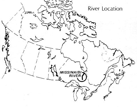
THE MISSINAIBI RIVER
ONTARIO
Situated in northeastern Ontario, the Missinaibi River flows northeasterly for 426 kilometres from the Abitibi Uplands north of Chapleau to its confluence with the Moose River in the James Bay Lowlands. It offers one of the longest, unimpeded stretches of wilderness river environments found in Ontario. Regulated as a provincial park by Ontario's Ministry of Natural Resources in 1988, the Missinaibi was nominated to the Canadian Heritage Rivers System for its unspoiled scenic beauty, varied natural
heritage features, its importance to the history of Canada's development as a major fur trading route, and the potential it offers to visitors for an extended wilderness canoe and camping experience.
Although this part of Ontario may be reached quite easily by road, rail and air from major population centres in southern Ontario and neighboring U. S. states, the Missinaibi River itself has more limited access, a factor which has contributed to preserving its unspoiled nature. Its designation as a provincial park and its inclusion in the Canadian Heritage Rivers System are intended to ensure that experienced canoeists will be able to explore the Missinaibi 's challenging white-water and wilderness scenery for many years to come.
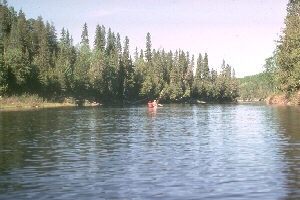
Lower Missinaibi approaching Hudson Bay Lowlands
GEOGRAPHY
From its source at Missinaibi Lake, just 5 km north of the division between the Great Lakes and
James Bay watersheds, 305 meters above sea lever, the Missinaibi River crosses two major
geographic regions - the Abitibi Uplands of the Precambrian Shield and the James Bay Lowlands. Its
watershed covers an area of 86,500 hectares. The Missinaibi is especially significant in that it provides
a link between Lake Superior, just over 100 km to the west via the Michipicoten River, and James
Bay, 72 km east via the Moose River - a fact which accounted for its very important role in the 18th
and early l9th century fur trace in Canada.
While there is some mining and logging activity in the general area of the Missinaibi, it is not visible to
visitors exploring the river. Except for a few small villages and towns at the rail and road crossings at
Peterbell and Mattice, the river corridor remains largely unchanged since its days as a fur trading
route.
The southern, upstream reaches of the Missinaibi flow through major lakes - Missinaibi and
Brunswick, and large wetlands at Hay River and Peterbell, while the river itself is here characterized
by a relatively narrow channel with numerous rapids and falls. In its central and longer, more northerly
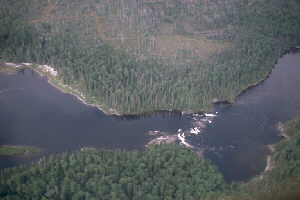
reaches, the river is generally wider and the flow slower, except for the area around Thunderhouse
Falls where the river flows swiftly as it drops through steep-walled gorges.
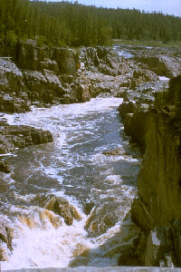
Gorge below Thunderhouse Falls
NATURAL HERITAGE
With unspoiled nature all along its course, the Missinalbi offers visitors opportunities to explore the full
breadth of naturel heritage typical of northeastern Ontario. Its most notable features are:
- Land and rock formations representing 2,500 million years of the evolution of the Canadian Shield;
- evidence of Precambrian, Paleozoic, Mesezoic and Cenozoic eras, showing glaciation and the
subsequent evolution of the river;
- dramatic geological formations such as those at Thunderhouse and Split Rock Falls;
- large mammals such as black bear and moose, and a small herd of elk at Missinaibi Lake,
introduced to the area in 1933; and
- the Peterbell string bog and marsh, habitat for a great number of interesting plant species, and for
waterfowl, moose, otter, and other wildlife.
HISTORY
For 140 years spanning the 18th and early 19th centuries, the Missinaibi River, with its links to Lake
Superior and James Bay, was one of the most important fur trading routes in Ontario. Used first by
Indians travelling to Moose Factory on James Bay to trade, the Missinaibi later carried traders from
the highly competitive fur trading companies, the Hudson' s Bay Company and North West Company.
In the interior, trading posts were built at Wapiscogamy House (1776), Missinaibi House on Missinaibi
Lake (1777), and at several locations on Brunswick Lake, starting with rival posts built in 1789 and
1796, respectively.
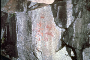
Indian Rock Paintings called Pictographs
The fur trade along the Missinaibi continued until 1879, and the succession of Brunswick House posts
served as a strategic centre for the fur trade throughout this entire period. The remains of Missinaibi
House, a Hudson' s Bay post, are a focus of interest for archaeologists and visitors alike.
The fur trade declined in the early part of the 19th century as the demand for furs, such as beaver,
fell in European markets. Later in the century, the area saw the completion of the Canadian National
and Canadian Northern rail lines. With the arrival of settlers by train, villages and towns grew up along
the rail corridors. More recently, the region was developed by the mining and lumber industries,
activities which continue here today.
Long before Europeans arrived, the Missinaibi Lake area was inhabited by nomadic bands of
Algonquin speaking people. Indian rock paintings called "pictographs" bear evidence to the region's
link with this pre-European past. The pictograph site at Fairy Point on Missinaibi Lake is considered
one of the most important in Ontario.
RECREATIONAL USE
The Missinaibi waterway provides fine opportunities for recreational activities such as lake and white-water canoeing, camping, wildlife viewing, and photography. Fishing for walleye and northern pike, lake sturgeon, smallmouth bass and brook trout is excellent on Missinaibi Lake and along the river.
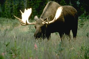
Moose
Most of these activities may be enjoyed by those using the provincial park campground at Missinaibi Lake, which is accessible by way of an 88km gravel road from
Chapleau. The Missinaibi River itself, however, has only limited access and lacks facilities and services. These characteristics enhance the river's wilderness appeal, but make it best suited to experienced travelers looking for a challenging, yet reasonably safe, wilderness canoe and camping trip
VISITOR INFORMATION
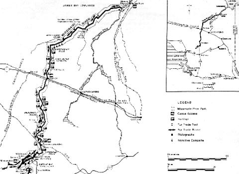
Access: Several starting points are possible, depending upon the length of trip desired. Missinaibi
Provincial Park campgrounds, at the head of the river, may be reached from Chapleau on Highway
101. The village of Missanabie may be reached via Highway 651 north from Highway 101. Via Rail
passenger trains run three times weekly northwest from Capreol, crossing the river at Peterbell and
the Ontario Northland Railway runs daily service from Moosonee to Cochrane, crossing the Moose
River just below its confluence with the Missinaibi. The lowest possible starting point downriver -
accessible by means other than float plane - is at Mattice, on the Trans-Canada Highway.
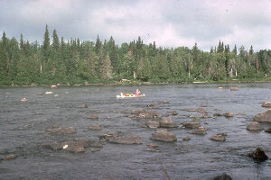
Canoe sailing, Missinaibi River
Accommodation and Services: Since this area is relatively remote, accommodation and services
are limited. The village of Missanabie offers hotel accommodation and supplies. Camping facilities
are available at Barclay Bay on Missinaibi Lake. Mattice has limited services and some overnight
accommodation. No established campground or other facilities are available for canoeists leaving the
Missinaibi at Moose River Crossing while waiting for the southbound train from Moosonee. However,
fly-in and fly-out services are available, permitting shorter trips.
Canoeing: While the entire Missinaibi may be tackled by experienced canoeists, most approach it
in two major sections. The upper Missinaibi River, from Missanabie village or Missinaibi Lake to
Mattice is a 236 km route with 28 portages requiring 10-12 days. The longer Missinaibi, from Mattice
to the Moose River rail crossing and on to Moosonee, is a 320 km route with 7-1O portages requiring
7-9 days. Detailed descriptions of these routes are available from the Ontario Ministry of Natural
Resources.
Canoeing is good from June to September. Portages, which are clearly marked, vary in length and
difficulty, and their locatians change with seasonally fluctuating water levels. The average gradient
along the river is less than 1 m/km; however, canoeists wishing to tackle the Missinaibi should be
experienced because the river has many difficult sections and numerous, changing portages.
Camping spots are limited on some portions of the river. The lower waters of late summer provide
additional camping sites on exposed river banks and sandbars, but also expose rocky shallows which
must be portaged or lined. For the experienced to expert canoeist, the Missinaibi provides a
challenging test of skill and endurance, particularly in June when water levers are higher.
Canoeing, Missinaibi River
FURTHER INFORMATION
Topographic Maps: The Missinaibi River is covered by 1:250,000 scale National Topographic
Series Maps Foleyet (42B), Kapuskasing (42G), Smokey Falls (42J), Moose River (42I), and
Moosanee (42P) - available from the Canada Map Office, 615 Booth Street, Ottawa K1A 0E9.
1:50,000 scale maps are available fram the Canada Map Office. The Public Information Centre,
Ontario Ministry of Natural Resources (OMNR), Queen's Park, Toronto can provide specialized canoe
trip maps for the entire Missinaibi at the l:l00,000 scale.
Missinaibi Provincial Park - Services, Permits and Regulations: OMNR Chapleau District Office, 190-
192 Cherry St., Chapleau, Ont. P0M IK0 Tel. 705-864-1710; or, OMNR Kapuskasing Area Office, 6-
8-1O Government Rd., Kapuskasing, Ont. P5N 2W4 Tel. 705-335-6191.
Tourist Information - Accommodation & Visitor Services: "1991 Ontario Traveler's Encyclopedia", free
from: Ontario Travel, Queen's Park, Toronto, Ont. M7A 2E5; Cochrane-Timiskaming Travel Assoc.,
Box 1162 Timmins, Ont. P4N 7K9 or James Bay Frontier Travel Assoc., Suite ll9, lO1 Mall, Timmins,
T4N 7H9; Ontario Northland Polar Bear Express Train, 65 Front Street West, Toronto M5J 1P6,
Phone: 416-965-4268.
Canadian Heritage Rivers System: Secretary, Canadian Heritage Rivers Board, Canadian Parks Service, Ottawa K1A 0H3; or, Ontario Member, Canadian Heritage Rivers Board, c/o Director, Ontario Parks and Natural Heritage Areas, Queen's Park, Toronto M7A 1W3.
Additional Reading:
- Harrington, L. "Canoe Country". Canadian Geographical Journal. August, 1946.
- Baldwin, D. & G. Taylor. "The Fur Trade in the Moose-Missinaibi River Valley: 1770-1917." Research Report #8. Ont. Min. Culture & Recreation. 1975.
- Newman, P. Company of Adventurers, 1985; Caesars of the Wilderness, 1987. Penguin Books.
- Reid, R. J. Grand. "The Missinaibi". In Canoeing Ontario's Rivers. Douglas and McIntyre. 1988.
- Harting, T. "Looking at Light". Nastawgan. Journal of the Wilderness Canoe Association. Spring, 1989.
- Reid, Ron. "Pictured Waters". Seasons. Federation of Ontario Naturalists. Spring, 1990.
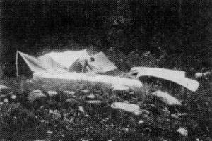
Setting up Camp on the Missinaibi