Esquimalt Graving Dock Waterlot Remediation Project
Table of contents
Background
The Esquimalt Graving Dock (EGD) is as an "open access" public ship repair facility that supports the local ship repair industry and fleet owners. As an "open access" facility, Public Services and Procurement Canada (PSPC) provides infrastructure, services, and multi-user access to the dry dock on a fee for service basis, to a variety of ship repair firms that perform work on domestic and foreign vessels.
The EGD has been used for the repair and maintenance of military and civilian vessels since 1927, and less stringent historical practices have contributed to sediment contamination in the seabed adjacent to the facility. This project will ensure that the water lot is remediated to meet federal and provincial environmental standards.
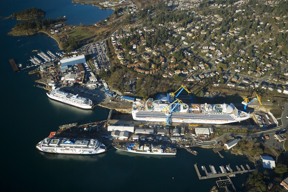
Figure 1 Aerial view of the site
Image description
Aerial photo of the Esquimalt Graving Dock (EGD) site from an oblique southern angle (approximately forty-five degrees off vertical), from approximately six-hundred metres above sea level. The EGD Operational, Upland and Waterlot areas are shown, along with adjacent military, industrial, and residential properties. Several ships are visible, including: a cruise ship in the dry dock, a B.C. Ferry along the North Landing Wall, and a B.C. Ferry and a Halifax Class Frigate along the South Jetty.
The primary contaminants of concern include metals (i.e., arsenic, copper, lead, and zinc), polychlorinated biphenyls (PCBs), and polycyclic aromatic hydrocarbons (PAHs). Other contaminants are present in lesser amounts.
The project involves four main components: dredging the contaminated sediment in the open-water areas of the water lot and disposal at licensed facilities (completed); construction of a temporary containment sheet pile wall around the South Jetty (completed); creation of new fish habitat (completed); deconstruction of the South Jetty and dredging the underlying area, followed by disposal at licensed facilities and removal of the containment wall.
The EGD Water Lot Remediation Project is funded by the Federal Contaminated Sites Action Plan (FCSAP), which is coordinated by Environment Canada and the Treasury Board to provide funding to assess and remediate federal contaminated sites.
In September 2012, PSPC awarded a $6.5-million contract to Salish Sea Industrial Services for the construction of the temporary erosion protection sheet pile wall (Phase 1A). The work was completed in April 2013.
In January 2013, PSPC awarded a $38.6-million contract to Tervita Corporation to remove contaminated sediment in the water lot and transport it to a licensed facility for disposal (Phase 1B). The dredging was completed in March 2014.
The open water remediation contract included structure demolition and disposal; temporary structure relocation and re-installation; water-based dredging and removal of approximately 140,000 cubic metres of contaminated sediment and associated debris by barge; upland transport and disposal of contaminated sediment at authorized Canadian disposal facilities; and placement of clean sand and rock armour on portions of the seabed in the water lot.
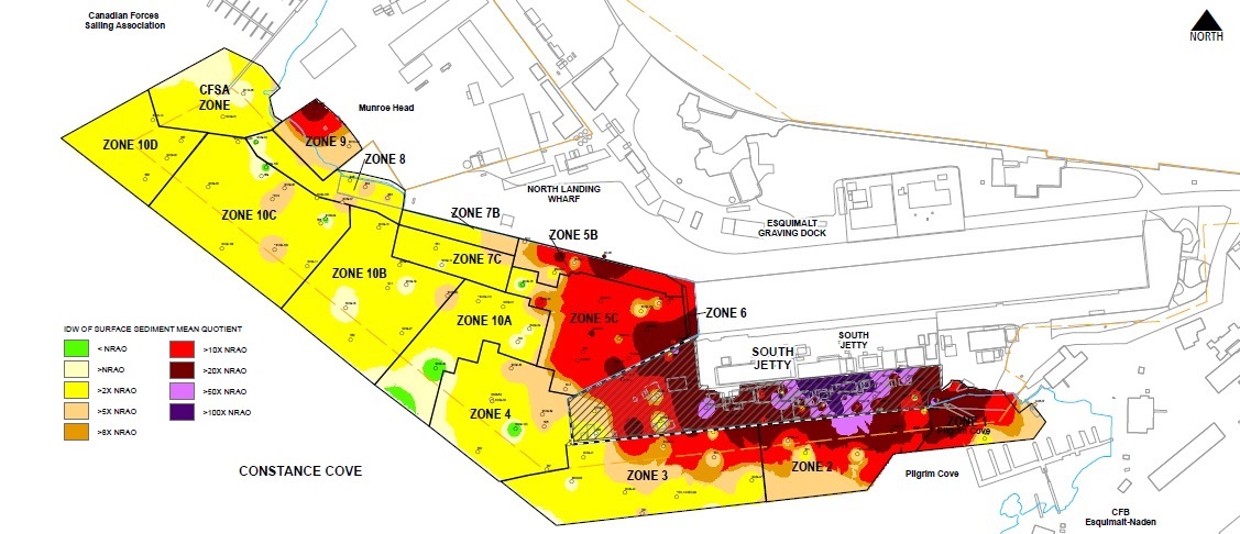
Figure 2 Phase 1B pre-remediation contaminant distribution
Image description
Pre-remediation plan view of the Esquimalt Graving Dock (EGD) Waterlot Remediation Project area, divided into eleven zones in the Phase 1B open-water remediation area, and the Phase 2 South Jetty under-pier remediation area. The zones are colour coded to depict the Inverse Distance Weighted (IDW) surface sediment mean contaminant concentration quotient for the Numerical Remedial Action Objectives (NRAO) for the project. Colour gradations are as follows: Green: = NRAO, White: >NRAO, Yellow: >2x NRAO, Pink: >5x NRAO, Orange: >8x NRAO, Red: >10x NRAO, Dark Red: >20x NRAO, Light Purple: >50x NRAO, and Purple: >100x NRAO.
Most of the Waterlot area away from the dry dock entrance and the South Jetty is Yellow, with some White/Green areas along the southwestern boundary. The areas nearest to the dry dock entrance and adjacent to the South Jetty are Red/Dark Red. The area under the South Jetty is primarily Red/Dark Red, with about one-quarter of the area under the jetty as Light Purple/Purple, indicating the highest concentration levels.
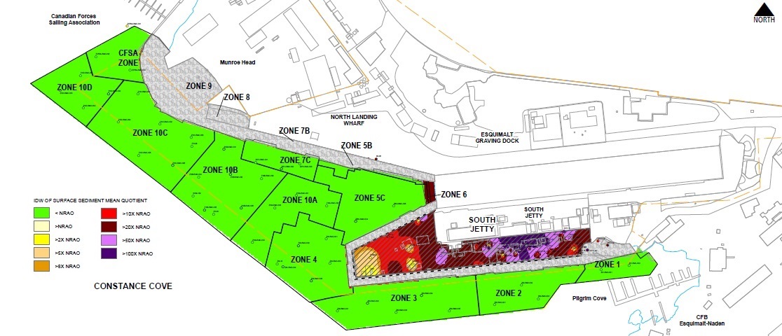
Figure 3 Phase 1B post-remediation contaminant distribution
Image description
Plan view of the Esquimalt Graving Dock (EGD) Waterlot Remediation Project area, divided into eleven zones in the Phase 1B open-water remediation area, and the Phase 2 South Jetty under-pier remediation area. The eleven open-water area zones show post-remediation site conditions after completion of Phase 1B remediation. The South Jetty under-pier area shows the Phase 2 pre-remediation conditions. A dashed line around the South Jetty perimeter shows the location of the erosion protection sheetpile containment wall that separates the Phase 1 and Phase 2 remediation areas. Grey shading around the sheetpile wall, along the face of the North Landing Wharf, and in intertidal areas shows the location of rock armour installed as part of the Phase 1B remediation. The zones are colour coded to depict the Inverse Distance Weighted (IDW) surface sediment mean contamination concentration quotient for the Numerical Remedial Action Objectives (NRAO) for the project. Colour gradations are provided as follows: Green = NRAO, White: >NRAO, Yellow: >2x NRAO, Pink: >5x NRAO, Orange: >8x NRAO, Red: >10x NRAO, Dark Red: >20x NRAO, Light Purple: >50x NRAO, and Purple: >100x NRAO.
All of the open-water area zones are Green except for the areas in Grey where rock armour was placed. Zone 6 at the entrance to the dry dock is Dark Red, as this area is a thirty metre setback from the edge of the drydock. The area under the South Jetty is primarily Red/Dark Red, with about one-quarter of the area under the jetty as Light Purple/Purple, indicating the highest concentration levels.
In August 2014, PSPC awarded a $2.4-million contract to TSUNUP Ventures Limited Partnership, for the construction of new fish habitat at Dunn's Nook in Esquimalt Harbour (Phase 1C). Approximately 5,400 square metres of new intertidal marsh habitat was created, to compensate for the temporary disturbance to fish habitat during the water lot remediation. The work was completed in April 2014.
Current work – phase 2 south jetty underpier sediment remediation
For the final part of the water lot remediation, in August 2015 PSPC awarded a $26.9-million contract for the South Jetty Under-Pier Sediment Remediation (Phase 2) to MNQM Contracting Limited. Work is anticipated to begin in the fall 2015 and continue through to spring/summer 2016.
The Phase 2 work includes demolition and offsite disposal of timber pile-supported sections of the South Jetty, re-use of timber components for marine protection of the remaining wharf infrastructure, removal/modification of mechanical and electrical utilities, re-driving of the existing sheet pile containment wall around the perimeter of the South Jetty, design and installation of a temporary sediment resuspension barrier affixed to the re-driven sheet pile wall, dredging of the seabed, and placement of engineered capping on the seabed after dredging. The total estimated quantity of sediment to be removed is 40,000 cubic metres. This includes approximately 200 cubic metres of sediment classified as hazardous waste under the British Columbia Environmental Management Act Hazardous Waste Regulation. The contaminated sediments are planned to be transported by barge to off-load facilities on the mainland at Richmond and Mission, and then by truck to the contractor's authorized treatment and disposal facility near Princeton, British Columbia.
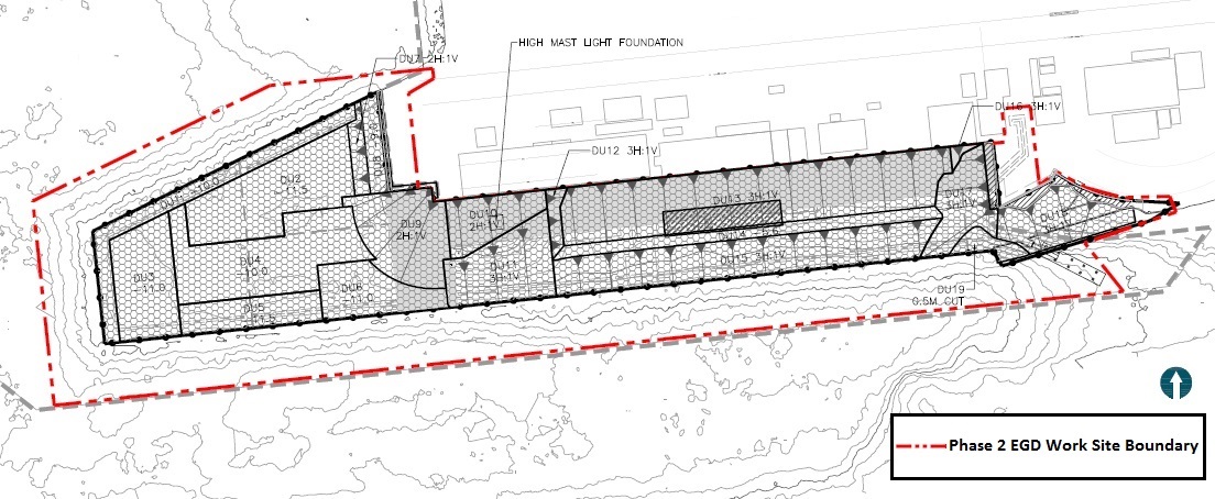
Figure 4 Phase 2 EGD work site boundary
Image description
Plan view of the Esquimalt Graving Dock (EGD) South Jetty Phase 2 Remediation Project Work Site Boundary, shown by a heavy red dashed line. The boundary is outside of, and parallel to the edges of the South Jetty, offset by approximately eighteen metres. Contour lines show seabed bathymetry and shaded areas underneath the South Jetty show discrete Dredge Units specifying required dredge depths.
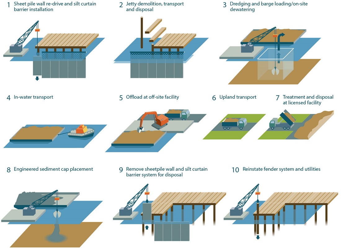
Figure 5 Phase 2 EGD sequence of work schematic
Image description
Schematic representation of the Esquimalt Graving Dock (EGD) Waterlot South Jetty Phase 2 Remediation Project work sequence, showing ten major activities:
- Sheet pile wall re-drive and silt curtain barrier installation
- A derrick drives the sheetpile wall to below the waterline and a barrier curtain is installed above the sheetpile wall.
- Jetty demolition, transport, and disposal
- The wooden jetty deck and timber support piles are removed and transported off-site for re-use, recycling, or disposal
- Dredging, barge loading, and on-site sediment dewatering
- Dredging occurs within the silt curtain barrier. Dredgate is loaded on to barges for dewatering.
- In-water transport
- A tug boat tows the dredgate laden barge.
- Offload at off-site facility
- An excavator unloads the dredgate from the barge, on to trucks.
- Upland transport
- Trucks transport the dredgate via road.
- Treatment and disposal at licenced facility
- Trucks unload at the off-site facility.
- Engineered sediment cap placement
- The engineered cap material is delivered by barge and placed on the seabed by derrick.
- Remove sheetpile wall and silt curtain barrier system for disposal
- The silt curtain barrier is removed and then the sheetpile wall is removed by derrick.
- Reinstate fender system and utilities
- Site utilities are reinstated and the fender pile system is re-installed by the derrick around the remaining steel-pile and concrete Jetty structure.
Contact information
For more information on this project, please contact the EGD Information Line at 250-363-0227.
Summary of under-jetty conditions from Esquimalt Graving Dock Waterlot detailed site investigation report
Site description and background overview
The EGD is the largest deep-sea shipbuilding and repair facility on Canada's Pacific Coast and has been operational since 1927 for the maintenance of private, government and military vessels. The EGD facility is located on the north shore of Constance Cove, in Esquimalt Harbour on the southern tip of Vancouver Island, within an area formerly known as Skinner Cove. Constance Cove and Esquimalt Harbour have a long history of naval and industrial activity, dating back to the mid-1800s. In 1921, PSPC began construction of the dry dock at Skinner Cove, a natural rock basin on the north shore of Constance Cove. The dry dock was formed by blasting and removing bedrock, with the blast rock used as infill in areas surrounding the dry dock to reclaim portions of Skinner Cove beyond the natural shoreline.
The EGD facility constitutes federal Crown-owned property, and is administered by Public Services and Procurement Canada. Esquimalt Harbour is administered by the Department of National Defence (DND) and is governed by the Canada Marine Act, Transport Canada's Natural and Man Made Harbour Regulations, and local practices and procedures. The Harbour Authority is the Queen's Harbour Master, Canadian Forces Base (CFB) Esquimalt.
The EGD facility comprises a Waterlot as well as Upland areas, and includes a jetty structure (the South Jetty). The under-jetty area comprises the area beneath the timber and steel pipe piled portions of the South Jetty and covers an area of approximately 1.2 hectares. Visual observations of the under-jetty area noted numerous creosoted timber pilings (existing and old cut-off piles), steel pipe piles, an existing sheet pile wall that retains the fill area to the south of the dry dock, "rip-rap" material located adjacent to the sheet pile wall and a fill mound located to the south of the timber crib. The fill mound appears to comprise granular fill, including brick rubble and possible waste sand blasting grit. Large amounts of debris including wood and metal fragments and pieces have also been observed beneath the jetty during site walkovers and underwater dive surveys.
Historic vessel maintenance operations at the dry dock resulted in discharges of contaminants into the Waterlot, including sand blasting grit, hydrocarbon based fuel, paints and potentially solvents. Historic operations on the South Jetty also potentially resulted in spills of fuel, paints, solvents and other materials which would either discharge into the Waterlot through storm drain outfalls, or discharge directly into the marine environment. Discussions with long-time dry dock staff identified that work was historically undertaken on vessels located on or adjacent to over-water structures, including marine slipways that were located in an area adjacent to the southwest corner of the South Jetty. In addition, dock staff identified that waste materials from facility operations were regularly deposited through a historical opening at the west end of the South Jetty and were burned on a mound of fill located to the south of the South Jetty timber crib structure. At the east end of the jetty, waste materials were also reported to have been dumped into a "Y"-shaped opening in the deck of the jetty.
Fire holes (to allow pumping of seawater for fire-fighting) within the deck of the South Jetty were considered to be a potentially important pathway for contamination to enter the marine environment as a result of stormwater run-off entraining contaminants from facilities previously located on the jetty (including a paint shop) and as a result of possible accidental spillages. The workshops/stores with the highest-deemed potential for contamination have since been moved to the North Landing Wharf (NLW) and moveable fire hole plugs are available to seal the holes in areas where work is being carried out.
Overview of historic site investigations, contamination and remediation
Several environmental studies have been conducted since the 1980s within the EGD Waterlot, in the under-jetty area, and within the greater Esquimalt Harbour to assess contamination within marine sediments. Historical sampling within the Project Area (EGD Waterlot) focused mainly on the collection of sediment grab samples, with a limited number of sediment cores to assess variations in the distribution of contaminants with depth.
Contaminants of potential concern (COPCs) are widely distributed within the EGD Waterlot; however, concentrations of chemical parameters are generally highest in areas adjacent to or beneath existing infrastructure, such as the South Jetty, and in areas of historical and/or ongoing industrial activities/operations. Historical reviews and sediment chemistry data collected as part of numerous historical and recent investigations within Esquimalt Harbour have identified the following key COPCs for sediments within the under-jetty area:
- Light/heavy extractable petroleum hydrocarbons (LEPH/HEPH) and polycyclic aromatic hydrocarbons (PAHs);
- Polychlorinated biphenyls (PCBs);
- Metals: mainly arsenic, copper, lead, mercury, and zinc;
- Tributyltin (TBT);
- Methyl mercury;
- Dioxins and furans; and
- Organochlorine pesticides.
In particular, with respect to the South Jetty, the "Y"-shaped opening at the east end of the jetty, previously used to dispose of waste materials, was subject to remediation in 2002 and 2003. Contaminated materials were excavated to the low water line and residual contamination was identified in samples collected from remaining sediments. Each of the samples collected had one or more PAH and metal parameter concentrations greater than federal Canadian Council of Ministers of the Environment (CCME) probable effects levels (PEL) guidelines (1999, updated 2002).
Furthermore, two samples had concentrations of phenanthrene greater than 10 x PEL and eleven samples had concentrations of one or more of copper, lead, mercury or zinc greater than 10 x PEL. Three stormwater outfalls also discharge to the under-jetty area; however, contaminant inputs from these outfalls are considered to be limited providing that downstream defenders are maintained effectively. However, prior to installation of the defenders, the outfalls may have historically provided a source of contamination to the under-jetty area, either through direct input of contaminated substances into upland stormwater drains or as a result of surface water run-off entraining contaminated residues present on the jetty surface.
A Detailed Quantitative Risk Assessment (DQRA) conducted for the Waterlot identified that metals, PAHs, TBT and PCBs accounted for the majority of risk associated with contaminated sediments. Specifically, the DQRA noted that:
- Copper, total PAHs and total PCBs correlate to the majority of toxicity endpoints;
- Biomagnification of TBT, methyl mercury and PCBs in benthic organisms may result in potential ecological risk; and
- Arsenic, cadmium, copper, methyl mercury, TBT, PCBs and dioxins and furans could pose a risk for human consumers of seafood, especially crab.
Due to the presence of contaminated sediments in the EGD Waterlot and in the under-jetty area, PSPC initiated detailed remedial action planning in 2009 and the development of an updated Remedial Action Plan/Risk Management Plan (RAP/RMP). Based on the assessment of remedial options, PSPC selected to implement a remedial dredging program (Remedial Alternative 2B) to remove contaminated sediments, based on exceedances of published federal and provincial sediment guidelines and standards, referred to as numeric Remedial Action Objectives (RAO's). Supplementary investigation activities to support the remedial options assessment and remediation design were undertaken between 2009 and 2012 to assess the subsurface conditions and the type and extent of contamination. These investigations have included sediment coring, sediment probing, borehole drilling, diver core sampling, and grab sampling.
The following section provides an overview of the results of the detailed site investigation (DSI) for the South Jetty area of the EGD Waterlot.
Overview of detailed site investigation results
A summary of the number of exceedances of each numeric RAO, and the maximum exceedance factor for each analyte group (defined as each analyte concentration divided by its respective numeric RAO), and the associated sample depth and location for the under-jetty area is presented in Table 1.
| Analyte group | Number of samples analysed (not including duplicates) |
Number of samples exceeding the screening criteria indicated (not including duplicates) |
Maximum exceedance factor of numeric RAOFootnote 1, Footnote 2 | Maximum depth greater than RAO (in m bml or m bgs) (location indicated in parentheses) |
|||
|---|---|---|---|---|---|---|---|
| ISQGFootnote 3 | PEL | CSRFootnote 4 | 10xPEL | ||||
PAHs |
92 | 84 | 66 | 66 | 45 | 1,474 | 6.71 (GBH09-09) |
PCBs |
53 | 38 | 34 | 34 | 14 | 50.4 | 4.88 (BH11-03) |
Metals |
89 | 88 | 56 | 54 | 32 | 182.9 | 6.40 (BH11-03) |
Dioxins and furans |
17 | 12 | 3 | 0 | 0 | 4.2 | 0.91 (BH11-03) |
Pesticides |
22 | 12 | 12 | 12 | 7 | 191.6 | 4.88 (BH11-03) |
- bml = below mudline
- bgs = below ground surface
Tributyltin
In addition to the analyses listed above, sixty-six samples (not including duplicates) collected from sediment cores, boreholes and surficial sediment samples in the under-jetty area, were analyzed for TBT; concentrations ranged from less than laboratory method detection limits (MDLs) to a maximum of 9.60 µg/g in a sample collected from diver core DC11-12 at a depth of 0 to 0.2 m below mudline (bml). A total of 36 samples had TBT concentrations greater than the Dredged Materials Management Program (DMMP) bulk screening limit of 0.073 µg/g; of the 36 exceedances, 20 had TBT concentrations that were greater than the low risk threshold of 0.75 µg/g and eight had concentrations greater than the moderate risk threshold of 2.5 µg/g.
The maximum sample depth at which TBT was reported at concentrations greater than the DMMP bulk screening limit was 4.39 m below ground surface (bgs) in borehole GBH09-01, located in the southwest area of the South Jetty.
The remaining samples collected from SMA-6 had TBT concentrations that were less than the applicable criteria or laboratory MDLs. Refer to Table 30.5 of the DSI for a summary of TBT results.
Pesticide analytes (Dichlorodiphenyldichloroethane, Dichlorodiphenyldichloroethylene, Dichlorodiphenyltrichloroethane)
Under-jetty samples collected from boreholes BH11-02, BH11-03 and BH11-06 and surficial locations DC11-01, DC11-06, DC11-15, DC12-06, DC12-15, and DC12-16 had concentrations of DDD that exceeded the numeric RAOs. Exceedances were identified to depths of up to approximately 4.88 m bml (at borehole BH11-03).
The maximum exceedance factor of DDD was 79.3 at location DC12-15, in a sample collected from 0.2 to 0.4 m bml. Furthermore, samples collected from borehole BH11-03 and under-jetty surficial sample locations DC11-01, DC11-06, DC11-15, DC12-06, DC12-15 had concentrations of DDT greater than numerical RAOs, with a maximum exceedance factor of 191.6 at DC11-06 in the sample collected from 0 to 0.1 m bml. Dieldrin concentrations in samples collected from under-jetty surficial sample locations DC12-06 and DC12-16 were greater than numeric RAOs, up to depths of approximately 0.3 m bml (DC12-16), with a maximum exceedance factor of 6.79.
At borehole locations GBH09-02, GBH09-04, GBH09-07, GBH09-11 and BH11-01, the reported pesticide analyte concentrations were less than laboratory MDLs; however, the laboratory MDLs for one or more of lindane (gamma – BHC), dieldrin, endrin, heptachlor and heptachlor epoxide were greater than applicable criteria, including instances where the laboratory MDL was greater than 10 x the numeric RAO. In these instances, the laboratory reported that the MDL was increased due to matrix interference. One or more of calculated total chlordane, DDD, DDE and DDT concentrations were greater than the respective guidelines; however, the individual isomer concentrations were less than laboratory MDLs and therefore the calculated concentrations were not identified as exceedances of the guidelines. Refer to DSI Table 30.7 for a summary of pesticides results.
Polycyclic aromatic hydrocarbons, polychlorinated biphenyls, and metals
Under-jetty sediment samples with concentrations of PAHs, PCBs and metals were reported above the respective numeric RAOs, including several samples that were in excess of 10x the numeric RAOs.
As expected for this area, given the historical practices described above, the presence of creosoted timber pilings and proximity to dock operations, contaminant concentrations in this area are amongst the highest in the Waterlot. In addition, due to the presence of deeper fill and thicker accumulations of unconsolidated sediments, contamination also generally extends to a greater depth within the marine sediments in this area of the Site.
Polycyclic aromatic hydrocarbons
The exceedances of the numeric RAOs for PAHs in this area are generally associated with suspected granular fill materials, upper fine grained marine sediments, and upper coarse grained marine sediments. Three surficial samples collected from beneath the South Jetty (two from DC11-06 and one from DC11-08) had total PAH Toxic Equivalency (TEQ) concentrations exceeding the applicable Environmental Management Act Hazardous Waste Regulation (HWR) standard of 100 µg/g, with a maximum PAH TEQ of 281.11 µg/g. The samples were not analyzed for leachability potential as the PAH TEQ data already indicated that the sediment was classified as Hazardous Waste.
The samples with the maximum depth exceeding the numeric RAOs for PAHs (naphthalene greater than 10 times PEL in a sample collected from GBH09-09 at 6.71 m bml, located towards the eastern extent of the under-jetty area) was associated with the Victoria Clay and a creosote/hydrocarbon-like odour was noted (potentially associated with creosoted timber pilings). The creosote/hydrocarbon-like odour was not observed in sediments deeper than the sample identified above.
Polychlorinated biphenyls
The exceedances of the RAO for PCBs were generally associated with unconsolidated marine sediments and fill materials; the maximum total PCB concentration in SMA-6 was 9.52 µg/g in diver core DC12-10 collected at a depth of 0 to 0.14 m bgs. The samples with the maximum depth exceeding the numeric RAOs for PCBs (BH11-03 at 4.88 m bml, located within the steel pipe piled portion of the South Jetty, near the fill mound) was associated with suspected fill materials with black staining.
Metals
The exceedances of the numeric RAOs for metals (arsenic, copper, lead, mercury and zinc) are generally associated with the unconsolidated marine sediments, fill materials, upper fine grained marine sediments and upper coarse-grained marine sediments. The sample having the maximum exceedance of the applicable numerical RAOs for metals (mercury) was from borehole BH11-04 at a depth of 0.61 to 0.91 m bgs. The sample with the maximum depth exceeding the numeric RAOs for metals, including a concentration of mercury greater than PEL, was collected from borehole BH11-03 at 6.40 m bml, located within the steel pipe piled portion of the South Jetty, near the fill mound. As discussed for PCBs above, this sample was associated with suspected fill materials with black staining.
Summary of conclusions and recommendations
The DSI provided data on contaminant distribution within the Project Area to support the development of the remedial dredging plan for the EGD Waterlot Phase 2 South Jetty Underpier Sediment Remediation Project, which involves full extent practical removal of contaminated sediments exceeding numeric RAOs.
Due to the presence of facility infrastructure adjacent to and within the Project Area, which is sensitive to undermining, and due to the depth of contamination present beneath the South Jetty and parts of the Munroe Head beach area, it is acknowledged that some undisturbed residual contamination is expected to remain in place following remediation. However, the volume of contaminated material left in-situ will generally be limited in comparison to the volume being removed. Engineered capping is planned to be placed on the seabed following dredging to prevent residual contamination from reaching the marine environment. It is understood that PSPC intends to undertake an assessment of the environmental risks associated with undisturbed residual contamination, for long term risk management of the material (where necessary). During remediation of the South Jetty underpier area, material contaminated with Hazardous Waste level concentrations of PAH's will be segregated and managed in accordance with the British Columbia Hazardous Waste Regulation.
With respect to TBT contamination in sediments, the proposed remediation will address a large portion of TBT contamination exceeding the moderate risk threshold for TBT in sediments. In the evaluation of the predicted TBT concentrations post-remediation relative to the current distribution of TBT in sediment, the current remediation footprint would result in a large reduction in the broad Constance Cove TBT concentrations.
Many of the COPCs at the EGD South Jetty are considered "legacy" contaminants, i.e., they are associated with historical industrial activities, processes and products (e.g., additives in vessel hull paint), which are no longer in practice or use and therefore recontamination of the area with these contaminants is unlikely. These include PCBs, select heavy metals (arsenic, mercury, lead), TBT, methyl mercury, dioxins and furans, and organochlorine pesticides.
However, it is anticipated that there are potential ongoing inputs of COPCs to the EGD Waterlot, including PAHs (associated with treated timber pilings), hydrocarbons, and metals, mainly copper and zinc, associated with ongoing discharges from the EGD facility operations. TBT may also be a potential ongoing COPC, but would be expected to decline now that the application of paints containing TBT has been banned within Canada.
PSPC continues to implement monitoring of operational discharges, including stormwater discharges, and undertake projects to upgrade facility infrastructure or management practices to further improve source control and potential discharges to the marine environment. PSPC has implemented an Environmental Management System (EMS), which includes Environmental Best Management Practices (EBMPs) that all contractors operating at the facility are required to adhere to.
Contaminated sediments from other parts of the harbour may provide a continued source of contamination however the magnitude of recontamination from harbour sources is likely to be reduced to concentrations currently seen within central Constance Cove (e.g., in the range of two to five times numeric RAOs). In addition, a harbour wide risk management strategy is being implemented by the Department of National Defence (DND), which is aimed at the longer term reduction of contamination within Esquimalt Harbour, with areas around DND shoreline being actively remediated through various proposed/planned construction projects.
Questions and answers
Q1. How is this work being funded?
A1. This work is being funded through the Federal Contaminated Sites Action Plan, which was created in 2003 to help federal departments and agencies manage risks associated with federal contaminated sites, especially those that pose the greatest risk to human health and the environment. The portion of the work involving the deconstruction of the South Jetty wharf structure is funded by the Accelerated Infrastructure Program 2 (AIP2), which was announced by the Government of Canada in spring 2015.
Q2. What is the goal of the work under this contract?
A2. The objective of this project is to clean up contaminated marine sediments in the seabed underneath the South Jetty, so that the EGD water lot meets federal and provincial standards.
Q3. What will the cleanup consist of?
A3. The cleanup will be done by dredging the seabed and disposing of the contaminated sediments at off-site authorized disposal facilities. As part of the work the timber-pile supported area of the Jetty will be removed to provide access for the remediation.
Q4. Why is the work being done?
A4. The cleanup of the water lot is a high priority for PSPC, due to the levels of contamination present and the potential for these contaminated sediments to migrate to other parts of the harbour. Remediation of the open-water area of the waterlot was completed in March 2014. The current under-pier remediation is the final phase of the overall cleanup of the water lot.
Under the Canadian Council of Ministers of the Environment National Classification System for contaminated sites, the water lot has been identified as "Class 1 – High Priority – Action Required."
This project has been initiated in support of environmental due diligence and liability/risk reduction under the Federal Contaminated Sites Action Plan (FCSAP).
Q5. What contaminants are present?
A5. The primary contaminants of concern include metals (i.e., arsenic, copper, lead, and zinc), polychlorinated biphenyls (PCBs), and polycyclic aromatic hydrocarbons (PAHs). Other contaminants are present in lesser amounts, such as tributyltin, dioxins and furans, pesticides, petroleum hydrocarbons and volatile organic compounds.
Q6. Is hazardous waste present?
A6. There is a small amount (approximately 200 cubic metres) of sediment underneath the South Jetty that is considered Hazardous Waste as defined by the Province of British Columbia's Hazardous Waste Regulation, due to elevated concentrations of Polycyclic Aromatic Hydrocarbons (PAH's). This material will be disposed of only at authorized hazardous waste management facilities in Canada.
Q7. How is this contamination currently being controlled?
A7. As part of the first phase of the waterlot remediation, a temporary steel sheet pile containment wall was installed around the perimeter of the South Jetty.
Q8. Where are the contaminants from?
A8. The primary source has been historical industrial activities such as ship repair and ship building, when work practices were not as carefully managed as they are today.
The current operations do generate copper and zinc residues, and improved site management procedures and environmental practices are in place to ensure these materials are contained and therefore reduce or eliminate potential future sources of contamination of the harbour sediments.
Q9. What is being done to prevent contamination?
A9. All operations at the EGD are required to comply with existing environmental legislation and standards. To further reduce the risk of environmental impacts from EGD activities, environmental management best practices are in place to provide added protection to the marine environment. These practices are taken very seriously and regularly undergo evaluations for continual improvement. Improvements to the site infrastructure also help to reduce environmental impacts.
Q10. What kind of work will the current project include?
A10. The work includes re-driving of the existing sheet pile containment wall around the perimeter of the South Jetty, design and installation of a temporary sediment resuspension barrier affixed to the re-driven sheet pile wall, dredging of the seabed, transport of the contaminated sediments by barge and by land, disposal at off-site authorized disposal facilities, and placement of sand and rock slope protection and engineered capping on the seabed after dredging.
To provide access for the remediation, the work also includes demolition and offsite disposal of the timber pile-supported sections of the South Jetty, re-use of timber components for marine protection of the remaining wharf infrastructure, and removal/modification of mechanical and electrical utilities.
Q11. Where is the work being done?
A11. The work is being done within the water lot of the Esquimalt Graving Dock, located in Constance Cove in Esquimalt Harbour, near Victoria, B.C.. The contaminated sediments will be transported by barge and by truck and/or rail to an authorized disposal facility in Canada that is selected by the Contractor. The current disposal facility the Contractor plans to use is located near Princeton, B.C.
Q12. What is the schedule for the cleanup?
A12. On-site construction for the South Jetty under-pier remediation is anticipated to start in the fall 2015 and be completed by spring/summer 2016. Some types of in-water work will be restricted during the standard fisheries closure windows from February 16 to June 30, and October 2 to November 30.
Q13. Where will the contaminated sediments be disposed of?
A13. The contaminated sediments will be transported by barge and by truck to authorized disposal facilities in Canada that are selected by the Contractor. Permit and licensing documentation for the facility or facilities will be verified prior to the start of work. The current disposal facility the Contractor plans to use is located near Princeton, B.C..
Q14. What approvals were required?
A14. The primary approval required was from Fisheries and Oceans Canada, under Section 35(2) of the Fisheries Act. An approval from Transport Canada, under the Navigation Protection Act was also required.
Q15. What work has been performed to date?
A15. In September 2012, PSPC awarded a $6.5-million contract to Salish Sea Joint Venture for the construction of the temporary erosion protection sheet pile wall around the South Jetty. Work began in October 2012 and was completed in April 2013.
In January 2013, PSPC awarded a $38.6-million contract to Tervita Corporation for the remediation of the open-water area of the water lot. The work began in June 2013 and was completed in March 2014.
The open water remediation contract included; water-based dredging and removal of 140,000 cubic metres of contaminated sediment and associated debris by barge; upland transport and disposal of contaminated sediment at authorized Canadian disposal facilities; and placement of clean sand and rock armour on portions of the seabed in the water lot.
In August 2014, PSPC awarded a $2.4-million contract to TSUNUP Ventures Limited Partnership, for the construction of new fish habitat at Dunn's Nook in Esquimalt Harbour. Approximately 5,400 square metres of new intertidal marsh habitat was created, to compensate for the temporary disturbance to fish habitat during the water lot remediation. The work began in September 2013 and was completed in April 2014.
For the final part of the water lot remediation, in August 2015 PSPC awarded a $26.9-million contract for the Phase 2 South Jetty Under-Pier Sediment Remediation. It is planned that approximately 40,000 cubic metres of contaminated sediment will be dredged and disposed of at authorized disposal facilities in Canada.
Q16. Why is this contract opportunity only open to Aboriginal companies?
A16. Providing opportunities for Aboriginal businesses is a priority for the Government of Canada, as outlined in the Government of Canada Procurement Strategy for Aboriginal Business announced on March 27, 1996.
Q17. What impacts can be expected at the Esquimalt Graving Dock when this project is underway?
A17. PSPC's intent is to conduct all projects at the EGD in a way that minimizes the impact on the shipyards, fleets, and staff. Due to the requirement to remove the timber-piled portions of the South Jetty to access the under-pier contamination, the marine vessel berthing space at the EGD will be reduced by approximately fifty-five percent. This disadvantage is mitigated by the fact that the area of the South Jetty to be removed does not currently meet operational requirements (load restrictions have been imposed) or seismic code requirements due to the design and deterioration of the aged wood structure. EGD clients and tenants are aware of the load restrictions and deteriorating condition, as well as the planned demolition. A separate capital project to redevelop the South Jetty is being examined.
Q18. What impacts are expected in local communities during the project?
A18. There may be increased truck traffic in local communities during the project, depending on the location of the authorized disposal facilities selected by the contractor. There may also be an increase in marine traffic, as all of the contaminated materials must be removed from the EGD work site by barge.
Q19. Will the cleanup generate excessive noise levels?
A19. Noise levels are expected to be consistent with typical operations at the EGD and will be managed to comply with the City of Colwood and Township of Esquimalt noise by-laws.
Q20. During what hours will the cleanup be conducted?
A20. Work is expected to be conducted during normal work hours at the EGD, which are 7:00 am to 11:00 pm Monday through Friday and Saturday, with allowance for activities outside normal work hours, as long as they are in compliance with the noise control by-laws.
Q21. Is PSPC going to pay local communities for increased wear and tear on roadways?
A21. The contracts issued by PSPC require that Contractors obtain and pay for any required permits, and pay any fees that are levied by local governments for the work carried out by the Contractor.
Q22. Will all of the contamination be removed as part of this project?
A22. A small portion of the contaminated sediment immediately adjacent to critical infrastructure cannot be fully removed without risks to the structural integrity of the existing dry dock or wharf structures. Some lower level contamination in deeper fill material underneath the seabed will also remain in place but will be covered with an engineered cap. The limited residual contamination that will remain in place will be monitored as part of the long-term risk management plan to ensure a high level of confidence that risks to people and the environment are being managed.
Q23. What happens at the end of the project? Who will monitor it and for how long?
A23. Sediment sampling is planned to be conducted by PSPC for five years following the remediation, after which results will be reviewed and long-term monitoring requirements will be evaluated.
Q24. What is the potential for recontamination?
A24. It is possible that some recontamination of the cleaned up seabed may result from redistribution of sediments from other parts of the Harbour into the project area. The Department of National Defence is planning to remediate other areas within the Harbour. The EGD's environmental programs and best management practices are in place to minimize or eliminate the potential for recontamination from ongoing shipyard activities.
Q25. How were the cleanup boundaries established?
A25. The project area for the Phase 1 open-water remediation was established to include the EGD water lot managed by PSPC, and an additional zone extending 30 to 50 metres past the legal boundary. The intent was to include all areas that may contain contamination from historical operations at the graving dock. The Phase 2 under-pier area is contained within the perimeter of the temporary sheet pile containment wall around the South Jetty.
Q26. Are there environmentally sensitive areas that could be affected by this project?
A26. The overall ecological rating of the water lot is "low". The results of detailed surveys conducted to detect sensitive species that may be present in the project area have been taken into consideration in the development of the project.
Q27. What type of habitat will be affected and how will this risk be mitigated?
A27. The South Jetty under-pier area consists of intertidal rock substrate and intertidal and sub-tidal unconsolidated sediments with a "low" habitat value. The sheet pile wall results in a temporary reduction in habitat quality, which has been compensated for as part of the creation of new intertidal marsh fish habitat at Dunn's Nook, as required by Fisheries and Oceans Canada. During the under-pier sediment remediation, a temporary sediment resuspension barrier will be affixed to the sheet-pile wall, to protect habitat and marine life in the surrounding area. Monitoring will be conducted to ensure that the environment is protected.
Q28. How is this work going to change things?
A28. The benefits of the project include the following:
- Improved condition of the project area sediments and associated sediment-dwelling organisms due to the removal of the contaminants, resulting in healthier and more productive communities;
- Reduction in the overall mass of contamination, resulting in a long-term reduction of harbour-wide contaminant concentrations;
- Reduction in the potential for migration of project area contaminants to off-site areas;
- Reduction in ecological risk and risk for human consumers of seafood. However, other sources of contamination in the harbour may continue to require fish and shellfish consumption advisories;
- Contamination levels will be reduced to comply with Canadian Council of Ministers of the Environment guidelines and B.C. Ministry of the Environment standards;
- Creation of new fish habitat;
- Elimination of Government of Canada environmental financial liabilities associated with the contamination that is removed.
Q29. How will the project affect fish and shellfish concentrations?
A29. As part of the sediment cleanup, the project will address contamination in the project area that has previously been identified as posing a potential ecological risk or a potential risk for human consumers of seafood. The cleanup of the contaminated sediments is aimed at reducing or eliminating unacceptable ecological and human health risks in the project area.
Q30. How does the project relate to the plan for the entire harbour?
A30. The project addresses contamination from the historical ship repair activity related to the operation of the EGD within the PSPC water lot and immediately adjacent areas of contamination. DND administers the remaining portion of Esquimalt Harbour and is currently planning to remediate other areas. The remediation of the EGD water lot is the first key step in improving the ecological condition of the Harbour.
Q31. How can I get more information about this project?
A31. For more information, members of the public can call the EGD Information Line at 250-363-0227.
Chemistry table
Table 2: Phase 2 Chemistry Data Summary is available on a separate page.
Footnotes
- Footnote 1
-
Exceedance Factor = (analyte concentration) / (analyte numeric RAO).
- Footnote 2
-
Refer to DSI Section 3.5 for further discussion regarding the numeric RAOs and DSI Table 29.
- Footnote 3
-
Number of samples exceeding Interim Sediment Quality Guidelines (ISQGs) does not include samples with concentrations less than laboratory detection limits – refer to DSI chemistry data tables and laboratory certificates of analyses.
- Footnote 4
-
B.C. Contaminated Sites Regulation (B.C. Reg. 375/96, including amendments up to B.C. Reg. 4/2014, January 31, 2014).
- Date modified: