| About us | Contact us | Services | Copyright | |||


| Back Issues | News & Events | Junior Rockhound | Resources | Clubs | Dealers | Web Links | Home |
| |||||
| | ||||
| |||||

|
Copyright
The Ice River Complex, By Rick Hudson
The Rocky Mountains are, of course, spectacular in their own right. But close to the town of Field in Yoho National Park, visitors will want to take a walking tour to the World Heritage acclaimed site of the Burgess Shales. You can't just stroll up, however. You must make a reservation (there are daily trips during the summer months) and go as part of a small guided group. Just to the west of the Rockies lies the huge Rocky Mountain Trench, which runs for over a thousand kilometres NW-SE alongside the Cambrian limestones of those well known peaks. But although the Rockies, the Shales and the Trench are justifiably well known, they are not the only geological wonder of the area. Just east of the Rocky Mountain Trench, in the western foothills of the Rocky Mountains not far from Golden, is the Ice River Complex – "one of the world's major alkaline intrusive bodies1."
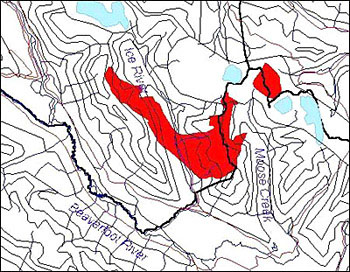
The Ice River Complex is an alkaline intrusion about 18 km in length in the shape of a stubby 'V', and covering slightly less than 30 square km (Fig. 1). It is surrounded by gently dipping Cambrian and Ordovician shales and carbonates typical of the local mountain region.
The older layer mafic units are feldspar-free, while the later nephaline syenites are low in silica, and host a variety of interesting minerals that excite rockhounds, including possibly the largest deposit of sodalite in North America 3. There are reports of a number of pegmatite outcrops, which suggest that further prospecting may reveal other deposits of semi-precious gemstones (such as tourmaline and beryl).
The two nearly parallel valleys of the Ice River and Moose Creek both drain south, the former being within the boundaries of Yoho National Park, while the latter is close to an active logging area (Fig. 2). Starting high in the alpine watershed of the eastern creek, the developed prospect known as Moose Creek near Sharp Mountain shows plutonic rocks comprised mostly of titanium-augite and magnetite, with pegmatite dykes and lenses. All the iron-rich minerals are present, including magnetite, sphene and ilmenite, but there are rare minerals too, which are of interest to the collector – namely knopite and sodalite, the latter appearing in veins. Further, niobium and columbium have been found in trace amounts, and a kilometre to the south, uranium, thorium and the rare earths lanthanum and ytterbium have been detected in small amounts.
The talus slopes under Mt Goodsir NW of Moose Creek have shown to be high in magnetite, and are the likely source of the alluvial material. The presence of the iron seems to make the mineral-bearing material break down more rapidly, so that the tailings in your pan will have most of the more interesting local minerals. There are current plans to work the slopes in some form of open cast system, to mine the iron reserves.
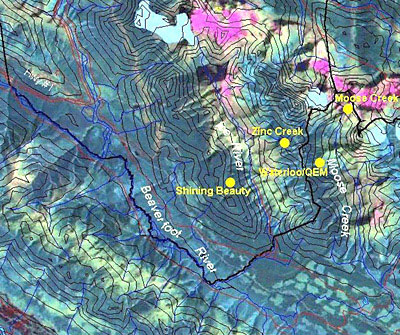
In 1970, a sodalite boulder weighing almost a ton was flown out for evaluation purposes. Reports from as early as 1947 indicated a sodalite showing occurs about 500m S-SE of Waterloo. Both sites are over 2,000m in altitude, so the snow leaves late (June) and returns early (September). Work in 1990 3 defined the syenite-sodalite area to be 500m long by 25m wide, and estimated it at over 300m deep. If correct, (drilling would be needed to confirm the extent of the deposit), this would make it the largest body of its kind in North America. At about the same altitude, south of Waterloo, NE of Zinc Mountain, and north of Buttress Mountain, the QEM claim has identified areas containing syenite material suitable for the ceramic and glass industry (and possibly as a building stone, if unfractured in large enough blocks) and a second sodalite deposit in the form of a vertical dyke running NNE-SSW for 175m, up to 25m in width and 50m deep. A boulder train had been known, but in 1990 Coquitlam, BC prospector S. Jaffer found the dyke at an altitude close to 2,000m Moving west into the Ice River valley, there are three mineral locales worth visiting, but be aware you are within a national park, and no collecting is permitted. Under the NW flank of Zinc Mountain, a steep stream flows west into the Ice River past a small showing high up at 2,000m, known as Zinc Creek. Small lenses and pockets of sulfides occur along strike in the calcereous shales. About 2km south of this junction, Sodalite Creek drains the SW side of Zinc Mountain. As the name suggests, sodalite float from unidentified veinlets have been seen in the runoff. Some 3.5km downstream from where Sodalite Creek meets the Ice River, a tributary from the west drains the Shining Beauty mine (high on the ridge, now inactive). Here, syenite intruded between steeply dipping Middle Cambrian calcereous shales and Upper Cambrian cherty slates. Within the area, quartz, limestone and traces of sulfides are apparent. The mine was active 1908-11, when three tunnels were driven along strike, about 60 metres apart up the hill, following a 60cm wide quartz vein which showed trace zinc, silver and lead. The upper two tunnels are each reported to be over 100m long.
The Mount Mather Creek sodalite prospect (sometimes called Mt. Laussedat) is located 30 km north of Golden, and is accessed via the Blaeberry River Forestry Road to Km 39�. Sodalite outcrops in a steep, narrow canyon cut by a small Blaeberry River tributary called Mount Mather Creek on the NW side. The property owner discovered the occurrence in 1957. At that time, there was already an old, short adit blasted into the main sodalite syenite breccia body. In the summer of 1996, the current owner began to develop the site, and mined about 3 tonnes of low grade sodalite breccia from loose boulders, to market for lapidary and ornamental use.
Syenites are intrusive igneous rocks containing potassium feldspars (plagioclase). They are named after the Syena District in Egypt. Elsewhere in the world, plagioclase feldspars are the source of sunstones and spectrolite/labradorite so popular with lapidaries. Deposits in Labrador (hence the name), Finland and Malagasay Republic. Syenite is often pale, having a pink or violet blush. Depending on chemistry and cooling history, trends towards pegmatite in certain situations. Visible crystals of biotite, magnetite, ilmenite common in the mass. An accessory is titanate – the source of titanium used in ceramics and paints. Nephaline syenites have a low silica content, and are found in association with leucite and analcite.
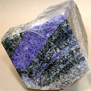
Sodalite (Fig. 3) is a sodium-aluminum silicate and is a fairly rare semi-precious gemstone. First identified in 1811, it is usually found in silica-poor, soda-rich intrusives such as at Bancoft, ON, home of the famous Princess Mine, which has produced much of Canada's material. The colour varies widely, but the blue tones are the valued properties. Hardness of 6 or less. Rare. Found in massive form, veins and lenses in nephaline syenites, and in crystal form in lavas at Mt Vesuvius, Italy.One variety fluoresces orange in both LW/SW ultra-violet light (hackmanite). Good samples from Mont St.-Hilaire, Quebec and Bancroft, Ontario. When calcium replaces chlorine in the structure, hauynite is formed. The deep blue variety, known as lazurite (lapis lazuli) has been prized for at least 4,000 years as a gemstone. Notable sodalite occurrences include Bancroft, Ontario; Mt. Vesuvius, Italy; Minas Gerias, Brazil; Cochabamba, Bolivia; Ice River, British Columbia; Maine, USA.
Tucked away just outside of the southern boundary of Yoho National Park, west of the Wapta Falls and Mt Hunter turnoffs, the Ice River region of steep river valleys and glaciated mountains can be accessed via the Beaverfoot Forest Service (Crozier) Road. This crosses the Kicking Horse River just west of Yoho N.P. boundary, and for 20km runs just outside the park on the southern bank of the Beaverfoot River. For the latest road info, call the Ministry of Forests in Golden at (250)343-7500. Access to the Ice River is complicated because the valley serves as a key grizzly bear corridor. There is a warden's cabin on the boundary. Check there on the status of access, or contact the Yoho National Parks Office [yoho_info@pch.gc.ca] in Field at (250) 343-6783 or FAX at (250) 343-6012. There is a blanket ban on mineral and fossil collecting in all national parks. The hiking trail up the Ice River is in good condition. In Moose Creek, a forest service road runs north to the foot of Buttress Mountain, after which the trail is poor to non-existent.
My thanks to Dr. George Simandl and Dr. Nick Massey of the BC Geological Survey, Victoria for discussions on this article, and to Ms. Sharon Ferris, Librarian at the BCGS Library, Victoria for assistance in tracking down the references.
1 Tony Peterson, 1983, Geology Thesis, University of Calgary on the Ice River Complex. 2 K.L.Currie, 1975, GSC Bulletin No.245, on the Ice River Complex. 3 Geological Reconnaissance Report (BC-GSC Rep No, 20,207), 1990 on the QEM Property, Moose Creek.
This article may not be copied, distributed or reprinted in any form without the author's permission. To contact the author, please use the e-mail address provided. If you are unable to contact the author, please contact the Canadian Rockhound. Authorized reprints must acknowledge the authors and the Canadian Rockhound, and include the website URL address of the Canadian Rockhound.
 
Copyright © 2001 Canadian Rockhound
Back Issues |
News & Events |
Junior Rockhound |
Resources
|