The Belgian ConnectionClaire Carbonez-Dejaeger, Exhibition Curator
By the approach of the 15th century, the Italian map-making centres in Rome and Venice were being overshadowed by specialists from Northern Europe. With the fall of Constantinople in 1453, which cut off the overland trade route to the Orient, and the discovery of the New World, the hub of world trade had gradually shifted from the Mediterranean to the Atlantic. In the course of the 16th century, the Flemish school of cartography became the centre of geographical study and map publishing, partly because the Southern Low Countries occupied a dominant position in world trade, partly also because the craft of printing and engraving had reached a high level of development. To keep competition at bay, the Spanish Court kept secret its information on the New World, and Iberian maps therefore circulated mostly in manuscript format. When the Southern Low Countries started the century under Emperor Charles V (born in Ghent 1500), they were among the richest areas in Europe and had been at the centre of Western civilization since the Middle Ages. Traditions of tolerance and humanism had slowly taken root. Towns like Bruges, Ghent and Ypres, Liège, Tournai, Brussels, Antwerp and Mechelen, had become centres of industry and trade, learning and culture. At the University of Louvain, Gemma Frisius (1505-1555) started a centre of cartography, where Gerard Mercator was a student.
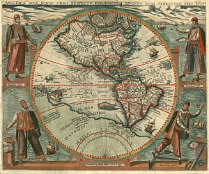
By 1540-50, Antwerp had emerged as the most important Western European commercial port and the greatest centre of world trade. The city was a meeting point for English, Hanseatic, Spanish and Italian traders and a distribution centre for oriental products brought to Europe by the Portuguese. With its 90 000 inhabitants, the city nurtured botanists and cartographers as well as artists, metal workers, printers and engravers. The latter had shifted from woodcut illustration to copperplate engraving. The same copperplate could be revised and reused to produce many editions of the same map or print, thus reducing the cost of materials and labour. As the new discoveries and explorations increased the demand for updated geographical material, engravers tried their hand at map-making. With the regular presence of Iberian and other navigators in Low Country ports, they had direct access to current geographic information from around the globe and soon began to publish the world's most accurate and popular maps in the late 16th century. Cartographers and chroniclers like Ortelius, Mercator, de Bry, de Jode, whose works are included in the exhibit, had all started lucrative businesses as goldsmiths, printmakers, antique sellers, before turning to cartography. Antwerp also counted numerous printing-houses and bookshops, the greatest of them being the house of Christoffel Plantin (1520-1589), a French immigrant. His house became world famous and an important tool in the distribution of the works, atlases and travel accounts on the New World, thus consolidating Antwerp's position as a centre of culture and knowledge. Most recently, in 2001, the archives of the Officina Plantiniana in Antwerp have been inscribed on UNESCO's Memory of the World Register.
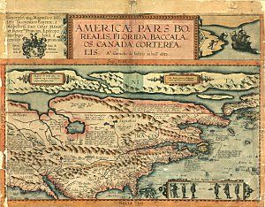
When Charles V abdicated in 1555, the Seventeen Provinces came under Spanish rule. During the Inquisition, about 100 000 burghers, mostly Calvinists, but also Catholics, chose to leave their native grounds for Holland and Zeeland, where they were free to profess their religion. It is a recurring pattern in the lives of the cartographers and authors on display in this exhibition. Many fled the oppressive regime and settled in Leyden or Amsterdam, where they contributed to the wealth and expansion of the Northern Provinces, which had separated from Spain by 1584. The National Library of Canada and the National Archives of Canada have collected several 16th- and 17th- century maps, atlases, and other authentic documents originating from scholars from present-day Belgium. The works of Johannes Ruysch, Gerard Mercator, Jodocus Hondius, Abraham Ortelius, Cornelius de Jode, Gemma Frisius, Cornelius Wytfliet, Theodore de Bry, and Johannes de Laet, are among the oldest authentic documents in the holdings of both institutions. The National Library’s Rare Book Collection has also acquired works of Catholic missionaries, Jesuits and Récollets, mostly from the province of Hainaut, who came to New France at the end of the 17th-century, Louis Hennepin being the most famous.
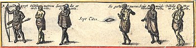
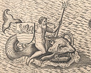
This exhibition has retrieved these treasures from their shelves. Some of the engravings are of exceptional quality; the maps and atlases, in original colour, are true works of art. The books relating the accounts of explorers are of utmost importance to the historian, as well as to the curious reader, who will distinguish patterns of similarity with the world of today. This exhibition reminds Canadians of the "Belgian Connection", the early contacts between our regions and Canada/the Americas. Although most cartographers and chroniclers on the New World had not actually been in the New World, contrary to the early missionaries, they provided in their maps, atlases and travel books, the paths on which subsequent adventurers and seafarers would engage into the New World. They disseminated information on the newly discovered peoples, their cultures, the flora and fauna and, most important, the riches of the new lands. Their maps and writings roused the curiosity and imagination of their readers, and depicted the New World as a place where colonists would want to make a new and a fruitful beginning.
|