
|
|
|
|
|
|
|
|
(Calling other countries to add their collections to the site) |
|||
General Information |
2003 |
2001 |
1993-1997 |
Copyright Information: According to the rules and regulations of the Barbara Petchenik Award Competition, the participants agree that their drawings may be reproduced by ICA, UNICEF or others without consultation or copyright fees as long as correct moral and ethical standards are adhered to. Copyright to the drawings is still vested in the author. The International Cartographic Association has given permission to Carleton University Library to reproduce the drawings submitted for the Barbara Petchenik Award by scanning and making them available on the Internet. Web design: Jeet Atwal
Database Information:. The information from the individual maps was entered into the database. The themes of the maps were further analyzed into five broad categories - Culture, Environment, Political, Peace and Conflict, and Other. "Culture" includes topics such as friendship, society, diversity, civilization and human development. Maps showing political boundaries were placed in the "Political" category. Maps with indeterminate or no themes are in the "Other" category. The name and school information is as provided. For errors and omissions please contact the webmaster.
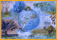
The theme for the 2003 competition was "Making a better world for children." A new page, "Exhibitions," was added to the web site with pictures from four different exhibitions of the children's maps. I'm looking for pictures from other past exhibitions to add to the page. Image files for the international entries are courtesy of Peter van der Krogt, University of Utrecht, The Netherlands and Alberta Auringer Wood, Memorial University, Canada. They were edited for this site at Carleton University. The pictures of the exhibition in Durban were taken by Alberta Auringer Wood. The Canadian entries were scanned by Gennie Leroux, 3rd year Sociology Honours student, Carleton University.
Jeet Atwal, Map Specialist, Maps, Data and Government Information Centre. Entries from the 2001 competition were added and the web site was completely redesigned and updated, July 2002. Thaaraha Selvarajah, a first year Systems Engineering student at Carleton. Thaaraha scanned the Canadian entries, helped with editing the images, the database and archiving of the maps. Almost all of the other maps were digitally photographed before the ICA conference at Beijing, by Dr. Peter van der Krogt, Faculty of Geographical Sciences, University of Utrecht. They were modified for this web site at Carleton University. Peter has a The theme for the 2001 competition was "Save the Earth."
Project Team: Jeet Atwal, Project Coordinator, Maps Data and Government Information Centre
Students:
All four students were responsible for scanning the maps. Stephanie, Jennifer and Kwasi assigned themes to the maps and entered data into the database. Todd and Kwasi also worked on the web pages. David Faguy developed the search engines for the project. He is an instrumentation/electronics technician. Email: raven@freenet.carleton.ca Special Thanks to: Heather McAdam for technical support.
Technical Information: Database: Microsoft Access 97
The maps were scanned at 72 ppi for web display and at 300 ppi for archival purposes. This project was finished and the web site posted in March 2000.
|
|||