Planning
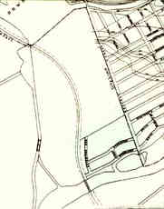 |  |
 | City plan detail, 1913. |
| City of Ottawa Archives
|
The first registered subdivision for part of the current
campus site was drawn up by J.B. Lewis in 1910. Four new streets were specified: Greenwood Drive,
Woodland Drive, Beresford Avenue and Beverley Avenue. That initial subdivision was located in the
southeast corner of Carleton. It extended from the current parking and administration buildings
east to Bronson and south of the river. This subdivision never progressed beyond the drawing stage. No roads were
established and no buildings were constructed to follow its configuration.
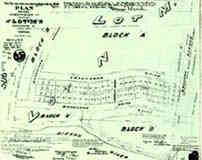 | |
| Subdivision plan for the south east corner of the site, 1910. |
| Land Registry Office
|
In 1915, the first comprehensive master plan for the
national capital metropolitan area was prepared. Most of this site was designated for residential
housing. Street layout was an extension of the previously registered subdivision plans.
The bywash from Hartwell's Locks was to be kept as parkland, while the railway right-of-way
was to be converted into an arterial road. Other green space was designated near Dow's Lake
and on a former island in the southeast corner of the campus.

