1965-68 : Towers and Parking Garages - continued
 |  |
 | Murray & Murray plan (1968) :
composite reconstituted bird's-eye mape to scale |
| Library, Special Collections and Archives
|
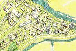
These two illustrations are based on the master plan studies prepared in 1968 by Murray & Murray,
architects and town-planners. The image to the left is a composite reconstituted bird's eye map to scale, illustrating both graphic and written
information from four different reports by Murray & Murray. Prepared especially for this study of conceptual plans of Carleton
University, the bird's eye map represents a useful method of analyzing previous master plan schemes, an improvement over
attempting to subjectively synthesize graphics and text from the Murray & Murray reports.
|
|
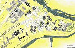 |
| Murray & Murray plan (1968) :
composite site map of long-term master plan of the site layout |
| Library, Special Collections and Archives
|
This three-dimensional representation combines planimetric information
with more pictorial data, as illustrated in the model and drawing views prepared in 1968. The method is useful for analyzing concepts which make extensive use of towers, most of
which were not previously represented in graphic form.
The image to the right is based on a composite from three maps,
found in two reports, by Murray & Murray. After preparing their reports, all undated, Murray & Murray extended the
campus development plan to include additional structures in the extreme southwest corner of the campus, beyond the
current Library Drive.

