 Official Name:
HARVEY PARK
Formerly: Burlington Heights, Kent's Paradise
Location: along York Blvd., west of Dundurn St. N., next to Dundurn Park, and across the street from Hamilton Cemetery - Ward 1
Size: 2.57 hectares (6.35 acres)
Official Naming Date: November 24, 1987
Features: field cannons, historical plaques, gravestone, walkways, picnic tables, benches
History
At the beginning of the 19th century, the area 250 feet above the waters of Burlington Bay, that would later become Dundurn Park and Harvey Park, was known as Burlington Heights. Colonel Richard Beasley (1761-1842), a pioneer, Hamilton merchant and politician, was the first person to officially own Burlington Heights from 1799. Beasley had been in the Hamilton area since at least 1793, and is an early settler of Hamilton. The Colonel built his first home, a log house, on the ridge between the present day Harvey Park and Dundurn Park.
Burlington Heights became a major point of defense during the War of 1812. In May 1813, American soldiers pushed the British back to Hamilton in an attack on Fort George at Niagara. The British set up a camp with earthworks, long and high ridges of earth built to protect soldiers during battle, all along the Heights. Parts of these mounds (also known as breastworks) can still be seen in Hamilton Cemetery and Harvey Park.
During the War of 1812, three battles were fought from Burlington Heights. In June 1813, Lieutenant-Colonel John Harvey marched soldiers from this stronghold to fight the Battle of Stoney Creek. Later, British and American fleets fought near York (Toronto) on September 28, 1813. The British, under the command of Sir James L. Yeo (1782-1818), sailed to the safety of Burlington Bay and the Heights in what was to be called the Burlington Races. Finally, in December 1813, Vincent marched his troops from Burlington Heights to recapture Fort George.
 In 1832, after the war, Beasley sold the 395.02 hectares (976 acres) of Burlington Heights to his cousin and trading partner, John Solomon Cartwright. Cartwright resold the property to Sir Allan MacNab the same year. Over the next thirty years, MacNab sold off parts of the Heights to several different people. Two of these properties would eventually be donated to the City and become Harvey Park.
Samuel Sylvester Mills (1806-1874), a merchant, banker, member of the legislative assembly and senator, bought the first 2,000 feet of the Burlington Heights area in 1867, and donated it to the City for a cemetery. In 1899, many years after Mills' death, his family gave the City permission to use this land for a park instead. The second donation came from Joseph Kent, a grocer and contractor, who was also an alderman from 1875 to 1881. He sold his land, named Kent's Paradise, to the City for $1 in 1876.
 The Battle of Stoney Creek, that was fought in the Burlington Heights area, turned the tide on the War of 1812 to the benefit of Canada and Britain. Therefore, on June 11, 1894, Burlington Heights Park was renamed Harvey Park in honour of the role John Harvey had played in that important battle. Harvey Park was transferred to the Parks Board much later in March 1927.
In 1894, the Wentworth Pioneer and Historical Society suggested that Harvey Park be used for the building of a museum and reception hall for the many historic objects they had collected. As Dundurn Castle opened a museum about five years later, it is assumed that Harvey Park was saved from such construction, because many of these objects were shown there.
Since 1991, several archaeological digs at Burlington Heights have uncovered many objects from, and facts about, the War of 1812 and previous uses for the land.
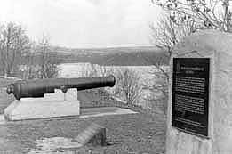 Two cannons, two plaques and a gravestone sit in Harvey Park. The cannons are British 24 Pounder Guns from Scotland and England engraved with initials of King George III (1760-1820), used during the War of 1812. The first plaque was unveiled in 1914 by the Wentworth Historical Society honouring the Burlington Races, and the 100th anniversary of the end of the War of 1812. A second memorial plaque honours the soldiers who fought at Burlington Heights. A granite boulder from Stoney Creek Battlefield was unveiled June 21, 1926, to mark an area nearby where Hamilton's soldiers, immigrants and citizens from the War of 1812, and victims of the ship fever and cholera epidemics, were buried in a mass grave. Later this grave was moved to an unmarked area of Hamilton Cemetery.
References:
1. Bailey, Thomas Melville, ed. Dictionary of Hamilton Biography. vol. 1. Hamilton: Griffin, 1981. p. 94-95, 154.
2. Clipping File. Hamilton - Parks - Harvey Park. Special Collections, HPL.
3. Corporation of the City of Hamilton, Department of Public Works and Traffic, Parks Division, Park Development Section. Parks Master Plan database, 1996.
4. Evans, Lois C. Hamilton: The Story of a City. Toronto: Ryerson, 1970. p. 63.
5. Hamilton Military Museum. Burlington Heights Map. 1996.
6. Herald Scrapbooks. vol. S4.1 - Stoney Creek. p. 13-15. Special Collections, HPL.
7. Picture Collection. Hamilton - Parks - Harvey Park. Special Collections, HPL.
8. The Hamilton Herald. December 17, 1921. p. 13.
9. The Hamilton Spectator. December 7, 1904. p. 10.
10. Thomson, Thomas M. Hamilton City Sketches. Hamilton: Board of Education, 1951. p. 57.
11. Triggs, John R. "Mapping the Heights and Digging the Ditch: Cartographic and Archaeological Research on Burlington Heights". Hamilton and Scourge Society Newsletter. vol. 3, issue 1. Summer 1996. p. 2-3.
