 Name:
Name:
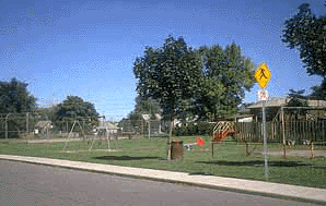
ST. CHRISTOPHER'S PARK
Also Known As: McAnulty Neighbourhood Park, St. Christopher's Tot Lot
Location: surrounded by Benson Ave., McAnulty Blvd., Holly Ave. and Grenfell St. - Ward 4
Survey Description: Plan 505, Lots 219 to 244, Lots 249 and 250
Size: 0.73 hectares (1.81 acres)
Features: playground, ball field
History
St. Christopher's Park is located on the former site of the Saint Christopher's Boys' Club, for which it is named. Although St. Christopher's Park has definitely seen better days, it is now scheduled for major redevelopment. Improvements should include a creative play structure, swings and a brand new sun shelter.
References:
1. Corporation of the City of Hamilton, Department of Public Works and Traffic, Parks Division, Park Development Section. Parks Master Plan database, 1996.
