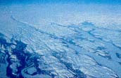
In Labrador, Canada presents a stern facade to Europe. The Torngat Mountains on the northern coast rise bleakly to 1,652 m, and elsewhere the Atlantic waves beat on an inhospitable and rugged shore. Fortunately north and south of Labrador there are great inlets into the continent: Hudson Strait, the Strait of Belle Isle, and Cabot Strait. South of the Strait of Belle Isle the Appalachian Mountain Range forms a great promontory of North America extending northeastwards into the Atlantic Ocean and ending in the island of Newfoundland.
Much smaller in area and lower than the
Cordillera, the Appalachians present to the Atlantic the ends of truncated
ridges and lowlands rather than unbreachable flanks. From the St. Lawrence
River across the Gaspé Peninsula and New Brunswick to the Atlantic
shore of Nova Scotia the Appalachians are 600 km wide. They rise as plateaus
and low rounded mountains to 1,268 m in the Gaspé, and to just over
800 m in both New Brunswick and the Island of Newfoundland. Indeed, Kicking
Horse Pass, elevation
1,622 m, in the Rocky Mountains is much
higher than any part of the Appalachians.
The skylines in Alex Colville's paintings of the Maritimes show the ruler-straight line of the sea or long ridges which are almost as even. But though the horizontal dominates, there is still much variety because of the patches and belts of hard and soft rock. The more resistant rocks have withstood erosion and form ridges, and the weaker rocks underlie the lowlands and valleys.
Except for the sea there are no expansive uniform areas such as are found elsewhere in Canada. No gentle coastal plain faces the ocean to encourage agricultural settlement. Out of the Atlantic abruptly rises a rocky shore, fortunately with innumerable harbours, and from the time of the Vikings in 1,000 A.D. the largest settlements have been on the coast. Only New Brunswick has large rivers which offer easy movement inland, the Saint John, and three with glorious rhythmic Indian names, the Miramichi, Restigouche, and Kennebecasis. Though the intricate coast became well known from the sea, in some areas the interior long remained a mystery. In 180102 the interior of Nova Scotia was reconnoitred by Titus Smith, long after the founding of Halifax, in 1749, and in Newfoundland it was not until 1822 that William Cormack walked across the island and reported that the interior was mainly a plateau.
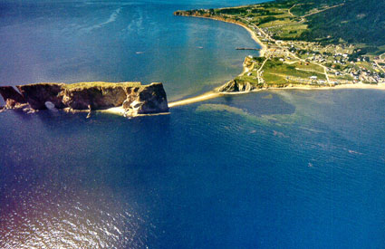
The Appalachian ridges are about five times as old as the Rocky Mountains. At one time they were folded into high mountains, but were eventually eroded into a relatively low mountain region. The grain of the folding runs fairly consistently southwest to northeast as the trend of headland and bays shows. On the west and northwest are two mountain ranges, the Newfoundland Highlands and the Notre Dame Mountains of the Gaspé Peninsula.They are not the usual mountains with sharp peaks; rather, the upper surface of each is as even as a plateau and then falls sharply in cliffs to lower levels. In the Gaspé, sharp short valleys are incised into them leaving most of the surface intact, and at the eastern end a small steep-sided remnant has been separated from the main mass by erosion, the famous Roche Percé. In the Newfoundland Highlands, glaciers once shaped the Humber Valley into an impressive fiord. A plateau-like surface continues eastward from these highlands across the island at a lower level with long promontories and deep embayments. Soil is thin and bedrock never far away, and small ponds and bogs are common in local depressions. Trees grow in the sheltered valleys and on the lower coastal slopes of the north central shore.
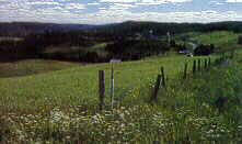
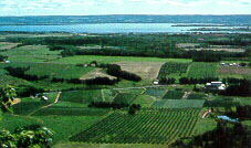
In the Maritimes a highland extends over north central New Brunswick, continues slightly lower along the western border of the province, and then turns eastward along the Bay of Fundy. These are rounded hills, forest covered; often they were cleared part-way up the slopes, but the trees always return as farmers leave the difficult soil. Within the arms of this higher land a broad undulating plain faces the Gulf of St. Lawrence, with such a gentle decline to the sea that the soil is poorly drained. Prince Edward Island, separated from the mainland by the 14 km wide Northumberland Strait, is part of this plain but its compact gently flowing surface, everywhere so close to the sea, is better drained. Sweeping eastward on the mainland along the Strait, the lowland extends in a narrower belt into Nova Scotia, and on this surface glacial deposits have helped produce some of the best soils in the province. Behind the plain lie the Cobequid Mountains, modest highlands much like those in New Brunswick. These mountain slopes were hard to cultivate, and often the farmers have left, but on lower slopes man has created a beautiful mix of forest and pasture. Local coastal flats on the Bay of Fundy were diked by the Acadians to keep out tidal waters, and hay is produced on these marshlands to this day.
Much of the Nova Scotia peninsula is a low rugged surface of igneous rocks, similar in form to the Newfoundland plateau. Patches of till and drumlins such as those at Lunenberg make farming possible. The Annapolis Valley is a very special landscape where sheets of lava which once overlapped older hard igneous rocks have been partially eroded to form a long narrow fertile valley parallel to the Bay of Fundy. A lava ridge called the North Mountain runs along the Fundy shore protecting the valley from damaging off-shore winds in winter. Northwestern Cape Breton is a high even plateau with sharp edges, actually cliffs, dropping steeply to the Gulf of St. Lawrence. The Cabot Trail alternately rises towards the plateau top and falls to the sea along this dramatic forested coast.
Glaciation has not helped to make the land here gentle and productive. Nowhere are the bedrock ridges and plateaus of the Appalachians far below the surface. Had they been covered by a thick mantle of glacial drift, some of the local ruggedness and poor drainage would have been modified, almost certainly creating better conditions for agriculture. Farmers take full advantage of the flood plains of riversthey call them intervalesfor pasture, hay, and other crops where possible.
Within the low mountain landscapes of the Appalachians, the drastic regional climatic contrasts like those of the Cordillera do not exist. Here on the eastern side of North America continental and maritime air masses interact. Temperatures fall low in winter and fluctuate from day to day as in an interior area, yet because of oceanic influences the amount of heat available in summer for plant growth is the lowest in southern Canada. Precipitation is adequate through the year, and most of the region is covered by a mixed forest of coniferous and deciduous trees. Because of the insular and peninsular thrust of the Appalachians into the Atlantic, weather is changeable. Huge sudden falls of snow can come late in spring and rains late in autumn. Cold ocean currents cause coastal fog, and keep the temperatures comfortably moderate in summer along the coast, although this prevents grain crops, which demand high temperatures, from ripening to perfection, especially on cooler high slopes. Winters are sufficiently mild in the sheltered Annapolis Valley to support commercial apple orchards.
As well known as the islands and peninsulas are the bodies of water which enter so strongly into the lives of people. The most important of these is the awesome Gulf of St. Lawrence. A smaller inland sea, Bras d'Or Lake in Cape Breton, is widely known for boating, and Bay of Fundy, only 4550 km wide, is famous for its tides which some day may be harnessed to produce electric power.
Off each of the ocean coasts of Canada lie continental shelves; low drowned sections of the continent, which on their outer margins vary from 180 to 366 m in depth before they plunge steeply down many thousands of meters to the great depths of the oceans. The Atlantic Coastal Shelf is the widest, (up to 700 km off Newfoundland), but the Arctic Shelf extends out for 160 km, and in the Pacific the shelf extends 120 km from the mainland to the western edge of the Queen Charlotte and Vancouver Islands. The fishing resources of the Atlantic and Pacific shelves have been of great importance for centuries, and in the past two decades off-shore oil reserves sufficient for commercial exploitation have been proven in the Atlantic and Arctic coastal shelves. The "Banks" of the Atlantic continental shelf have long been named; the Grand, Georges, Scotia and many more, are familiar fishing grounds, and their productivity partially compensates for the absence of a productive coastal plain above the surface.