Great
Lakes-St. Lawrence Lowlands and the Great Plains
Gently sloping sedimentary rocks, their
smooth lines occasionally broken by abrupt linear escarpments, overlap
the much older Canadian Shield on its southern and western margins. Observant
fur traders, including Sir Alexander Mackenzie, remarked on the succession
of huge lakes arrayed in a line along what we recognize as the boundary
between the Canadian Shield and the relatively easily eroded sedimentary
platform. From Lakes Huron and Superior in the south they sweep in a great
arc right across Canada through Lakes Winnipeg, Athabasca, Great Slave
and Great Bear towards the Arctic, revealing by their presence where two
great natural regions of Canada meet.
Along the Lower Great Lakes and the St.
Lawrence River the sedimentary platform is relatively narrow, 300 km at
its widest but usually much less, a low area snugly placed between the
Shield and the Appalachians. From the Shield to the Rockies the sedimentary
beds are much more extensive. The land is commonly thought to be level,
but in fact it rises imperceptibly to the west over a distance of 1,150
km. Northward the sedimentary platform narrows to 150 km in the Mackenzie
Basin, and 2,600 km from the 49th parallel the plains reach the Arctic
Ocean.
 Let
us look first at Southern Ontario and Quebec. In travelling from the Shield
to these sedimentary plains a remarkable transformation takes place as
we go from rough forested lake-strewn terrain to gentle open farm countryside.
It is not always thus, although in the 17th century Champlain had already
noted the difference between the difficult country of the Shield and the
pleasant lands to the south better suited for settlement. Great forests
covered this country, and the trees approached those of the British Columbia
coast in magnitude. But in the Lowlands of Quebec and Ontario over many
generations the towering forests were cleared, making way for close settlement
and the kinds of landscape shown in the paintings of Homer Watson.
Let
us look first at Southern Ontario and Quebec. In travelling from the Shield
to these sedimentary plains a remarkable transformation takes place as
we go from rough forested lake-strewn terrain to gentle open farm countryside.
It is not always thus, although in the 17th century Champlain had already
noted the difference between the difficult country of the Shield and the
pleasant lands to the south better suited for settlement. Great forests
covered this country, and the trees approached those of the British Columbia
coast in magnitude. But in the Lowlands of Quebec and Ontario over many
generations the towering forests were cleared, making way for close settlement
and the kinds of landscape shown in the paintings of Homer Watson.
These Lowlands began to be studied by geologists
in the mid-19th century. The Geological Survey of Canada, under its great
founder Sir William Logan, had little trouble in identifying the formations
because European and American classifications of strata were readily applied
to those rocks. However, there are differences between the surface features
of the Ontario and Quebec Lowlands.
In Ontario the almost horizontal bedrock
surface is broken by the abrupt wall of the Niagara Escarpment which crosses
the Ontario peninsula from the Niagara River to Manitoulin Island in a
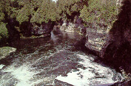
sinuous line. Strong dolomitic limestone rocks at the top protect the weaker
beds below. Many attractive waterfalls drop down the wall. The most magnificent
of all, the 44 m Niagara Falls, down which the waters of the Upper Great
Lakes pour on their way to Lake Ontario, has cut back 10.5 km from the
edge of the Escarpment leaving the Niagara Gorge as evidence of the great
erosive power of water. The surface of peninsular Ontario has been enormously
affected by glaciation. A great accumulation of glacial till, much thicker
than in the Appalachians and inherently more fertile because it is largely
derived from limestone rocks, profoundly affects our perception of the
landscape. Long sags and rises in the land, swelling into smoothly curved
drumlins in some areas, have produced a soft undulating countryside, a
land of easy gracious contours. Rough morainic ridges and flat former lake
beds provide the element of contrast, but this is never a land of edges
except where bedrock is exposed in the Escarpment. The rivers have cut
deep ravines, but mainly they fit into the landscapes and do not organize
it except where the Ottawa and St. Lawrence Rivers lead into Quebec. This
expansive till surface underlying the well drained soils provided, when
cleared, a magnificent base for agriculture. But the area also benefitted
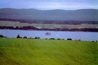
greatly from the presence of the Great Lakes which have become a vital
part of the economic organization of the region.
In Quebec the Lowland is narrow, with the
Laurentides and the Appalachians always visible as a backdrop. Life is
concentrated on the plain. After deglaciation the lowland was covered by
an arm of the ocean, the Champlain Sea, and the marine deposits produced
a flatter surface than the tills of Ontario. The serenity of this plain
is broken, not by a linear escarpment as in Ontario, but by a line of eight
independent hills protruding abruptly 180 to 300 m above the flat floor
along a distance of 80 km, each hill roughly round in outline and a few
km2 in area. These are the Monteregian Hills, possibly the necks
of former volcanoes now eroded. Mount Royal in Montreal and Mount St. Bruno
are the best known of these eminences.
If Ontario has been influenced by the Great
Lakes, Quebec has been equally affected by the Great River. For centuries
the St.Lawrence has been at the centre of life in Quebec, simultaneously
providing splendid access to interior Canada and making possible the national
transportation role of Montreal in Canada. The St. Lawrence River together
with the Great Lakes form the greatest inland waterway in the world, shared
in large part with the United States. The system is only broken by the
rapids and falls in the St. Mary's, Niagara and St. Lawrence Rivers, all
of which were overcome by canals and locks in mid-19th century.
Peninsular Ontario is a battleground for
northern and southern air masses throughout the year, and the weather usually
changes every few days to the beat of the air masses coming through. Precipitation
is ample for agriculture and evenly distributed through the year. Much
of the moisture comes from air masses originating in the Gulf of Mexico.
In summer they can bring hot muggy tropical discomfort, with hardly any
cooling at night. This is a continental climate and the winters are cold,
but there are frequent mild spells as southern air moves in. The summers
are the hottest in Canada. They are long enough, with a growing season
of up to 220 days, and accumulate sufficient heat to permit corn to grow
almost as well as in the American Middle West.
 And
the tempering effect of the lake waters keeps temperatures from dropping
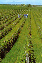
too low in winter along the lake shores so that peaches and grapes can
be grown commercially on the coasts of Lakes Erie and Ontario, and apples
more widely. In Eastern Ontario and the St. Lawrence Lowland of Quebec
the heat accumulated in the warmer months is not as great as in the peninsula,
so hay and pasture and mixed farming become more important. In October
there may be a week or more of unseasonably warm hazy weather in southern
Ontario and Quebec; this is the famous Indian Summer of North America.
And
the tempering effect of the lake waters keeps temperatures from dropping
too low in winter along the lake shores so that peaches and grapes can
be grown commercially on the coasts of Lakes Erie and Ontario, and apples
more widely. In Eastern Ontario and the St. Lawrence Lowland of Quebec
the heat accumulated in the warmer months is not as great as in the peninsula,
so hay and pasture and mixed farming become more important. In October
there may be a week or more of unseasonably warm hazy weather in southern
Ontario and Quebec; this is the famous Indian Summer of North America.
Before settlement a mixed forest covered
most of the Lowland. Only in the highly favoured area of hot summers and
less chilling winters in southwestern Ontario did a fully mature deciduous
forest flourish. In marked contrast to the boreal forest this area had
an extremely rich variety of trees including elm, maple, oak, walnut, beech,
chestnut, hickory and sassafras trees; there were also stands of huge white
pine on light well drained soils. This deciduous forest and the adjacent
mixed forest were largely destroyed in the 17th, 18th and 19th centuries
in Ontario and Quebec and now the land is covered by farms and cities.
The Great Plains are on another scale entirely,
and the fact that large sections are grasslands means that the essential
flatness of the region could be appreciated at an early date and did not
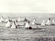
have to await the clearing of forests as in Ontario. The Indians and fur
traders regarded the grassland as buffalo country, and recognized that
the rim of woodland surrounding the prairie was an imortant natural boundary.
It was the geologist James Hector of the Palliser exploring expedition
who gave additional conceptual form to the southern plains so that people
could more easily comprehend them. Hector identified the low area in present
Manitoba next to the Canadian Shield, then the abrupt rise to the west
to a higher level at what we know as the Manitoba Escarpment, next another
rise farther west against the Missouri Coteau, and finally a gradual slope
to the Rocky Mountain foothills. This concept of three prairie levels has
been popularly accepted. Most of the westward lift is accomplished in the
gentle incline of the three levels, Winnipeg at 240 m can be compared to
Regina at 574 m and Calgary at 1079 m a.s.l.
Most of the surface of the Great Plains
is till, but here it is much more spread out than in Ontario. Enormous
flat clay deposits enhance the impression of overwhelming space; they include
what is easily the largest level plain in North America, that of glacial
Lake Agassiz in Manitoba. Variation is introduced by flattopped hills,
remnants of a former plateau composed of weak rock, which stand out like
islands in the plains, especially since they are forested. One of the residual
plateaus, the Cypress Hills, higher than the others and located where the
Alberta, Saskatchewan and U.S. borders meet, remained just above the ice
sheets in the last glaciation and thus became a refuge area for plants.
Other highly treasured contrasts to the general plains surface are the
great valleys incised deeply into the plain by major rivers such as the
Saskatchewan and Assiniboine. The Saskatchewan-Nelson River system drains
the southern sedimentary plains into Hudson Bay, but the rapids-filled
passage across the Shield is too difficult for use by any mode of transport
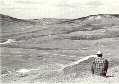
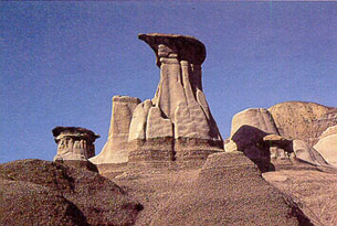
except canoes or York boats. In the more arid sections of southern Saskatchewan
and Alberta the soft banks of rivers unprotected by grass or trees have
been minutely dissected by water into sharply gullied badlands. But mostly,
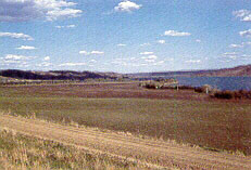
the wide, flat-floored valleys are thinly wooded on the sides with meadows
on the floodplains below, and may contain lakes as in the Qu'Appelle Valley.
Canada has two great treeless zones, the
Barren Grounds we have already looked at, and the grassland areas of the
Great Plains, located in an arid climate. As precipitation in the boreal
forest region gets lower and as evaporation increases to the south, the
woodlands become more open, and a transition zone of aspen copses and meadowland
called the Park Belt, appears between the forest and the grassland.
Within the grassland itself sub-regions
can be recognized. The fur trader David Thompson, writing in the 1840s,
distinguished between the tall grass meadows next to the Park belt, often
called prairies, and the short grass plains of the driest sections. Though
the broad zones of forest and grassland are governed by climate, the exact
location of the Park Belt may have been determined by early man's use of
fire.
Within the plains there is a widely recognized
gradient or decrease westwards from the Red River to the Rockies in both
the amount and reliability of the precipitation. Adequate precipitation
in summer and high day-time temperatures make southern Manitoba and southeastern
Saskatchewan ideal for spring wheat growing, but in drier southern Alberta
ranching and irrigation take over. Northward on the prairies there is enough
precipitation for grain growing and mixed farming, but agriculture is limited
by a 90 day dependable frost free season. The prairies have the most extreme
continental climate in Canada. Winters are bitterly cold, but fortunately
the weather is bright and crisp and snow remains firm underfoot. It is
not the depth of the cold, but the length of the winter and the need to
be constantly warmly dressed when outdoors which by late winter proves
wearing on everyone. Blizzards are a hazard but can be coped with if people
have the common sense to stay in and wait them out. In summer the days
are blazing hot and the humidity is low, which produces high quality grain
and is attractive to people who like the sun. The evenings and nights are
cool, inviting outdoor activities and permitting restful sleep.
North of the Park Belt similar combinations
of plains, low plateaus and valleys continue as in the south, but all are
forested so that the contrasts are not as marked between the flat-topped
erosion remnants of plateaus and the generally surface. In the Peace River
Country a glacial lake plain, well drained by the magnificent Peace, is
a fertile pocket of land. Mild Pacific air modifies the temperatures here
so that the grain safely matures in northwestern Alberta. However, in much
of the area drainage is so poor that muskeg abounds and prevents agriculture.
The Athabasca River runs through sand areas saturated with oil, first noted
by Peter Pond in 1788. These are now being exploited, and comprise Canada's
greatest known reserve of oil.
As the sedimentary plains narrow to the
north, another of Canada's master streams, the Mackenzie River, becomes
the dominant feature. The Mackenzie drains into the Arctic Ocean the northern
plains and part of the Shield, and through its tributaries, the Peace and
Peel, it also drains part of the Cordillera. In summer, tugs and barges
connect Great Slave Lake to the coast. Many optimistic claims used to be
made concerning the potential for development of the Mackenzie Basin, but
essentially the basin remains a corridor for movement to the Arctic where
oil is produced at Norman Wells. North of Great Slave Lake permafrost is
widespread and close to the coast it is continuous. Even when the surface
melts in spring the sub-surface frozen layer impedes soil drainage and
encourages soil slumping on even the slightest slope. As in all of Arctic
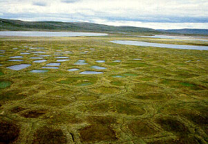
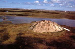
Canada alternate freezing and thawing produces patterns in the ground such
as polygons, and the Mackenzie Delta is famous for small hills looking
like domes, called pingoes, formed of layers of ice and ground. Thus permafrost
is a fragile environment where engineers have to take into account the
summer surface thaw in any construction project.
In settling some of these lands man made
tremendous changes, destroying forests and obliterating grasslands in the
act of creating farmlands and cities. In this century we have recognized
the need for stewardship of all the lands and waters of Canada. Not only
are the unstable environments of the permafrost areas of the North now
known to be vulnerable but we have been shocked to discover that the chemical
pollutants produced in the everyday life of our industrial civilization
are increasingly destroying vegetation and wildlife and contaminating our
lakes and rivers. Two centuries after Mackenzie the face of nature in Canada
is one we know well, but we also are learning that we alone can preserve
its majestic beauty.