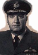
Keith
Greenaway
Pioneering
Arctic Aerial Surveyor
 Imagine
standing at the North Pole, at the very point where all the north/south
longitudinal meridians of the earths globe intersect. You want to go south
to your home. South lies in front of you, to your left, to your right,
as well as behind you. One of those southerly meridians leads directly
to Greenwich, England; another leads to the middle of the Pacific Ocean;
only one south will take you home.
Imagine
standing at the North Pole, at the very point where all the north/south
longitudinal meridians of the earths globe intersect. You want to go south
to your home. South lies in front of you, to your left, to your right,
as well as behind you. One of those southerly meridians leads directly
to Greenwich, England; another leads to the middle of the Pacific Ocean;
only one south will take you home.
At one time Keith
Greenaway was the only aerial navigator in the world who could direct exactly
how to get where you wanted to go from that imaginary geographical pinnacle.
Today he is the acknowledged master of aerial navigation in the high polar
regions. In actual fact, immediately following World War II Keith pioneered,
developed, and refined Arctic air exploration.
Accurate navigation
in the north is immensely complicated because the geographic pole (the
place where you were imaginatively standing in the first paragraph) does
not correspond exactly with the magnetic pole (the place to which the compass
needle points). In 1995, for instance, the magnetic pole was in the Noice
Peninsula on Ellef Ringnes Island, hundreds of miles from the geographic
pole. In the year 2185, give or take 20 years, the meandering magnetic
pole will actually bisect the geographic polar position.
Accordingly, a very
large area of magnetic compass unreliability exists for aerial navigators
throughout the entire magnetic pole region. For approximately 1,200 miles
from east to west and 2,000 miles north to south, the magnetic compass
is completely unreliable as a directional indicator, primarily because
of very strong magnetic influences.
In the absence of
a useful magnetic compass, the aerial navigator must determine an accurate
method of assessing direction. Understandably, ability to establish headings
is essential. No less important is the ability to maintain proper headings
once they have been established.
Kenneth Maclure,
Group Captain of the Royal Canadian Air Force, was a staff member of the
Empire Air Navigation School in England. In April 1945, at the conclusion
of a longrange polar flight in an Aries aircraft of the Royal Air Force,
the EANS staff visited the RCAF Station at Rivers, Manitoba. It was there
that Keith Greenaway, then attached to the RCAF's Central Navigation School,
heard from Maclure of the difficulties involved in Arctic aerial navigation
and of Maclure's early study of a grid system aimed at simplifying the
plotting of navigational headings in the North.
Within a year following
his encounter with Maclure, Greenaway was afforded a once-in-a-lifetime
opportunity to develop and test his own modified grid system. He was posted
to the Canadian section of the United States Air Force's B29 Superfortress
Detachment at Edmonton, Alberta. There he was involved with the USAF in
modifying Maclure's pioneering grid system for practical use in the western
hemisphere. Greenaway at the time was a navigator on board the first American
military aircraft to cross the north geographic pole on May 9, 1946.
While creating a
navigational polar grid for Arctic aerial navigation, Greenaway, in early
1947 discovered the wandering ice island later named T3. The huge ice mass
was subsequently equipped with weather instruments that provided to Canada
and the rest of the world valuable information about Arctic conditions.
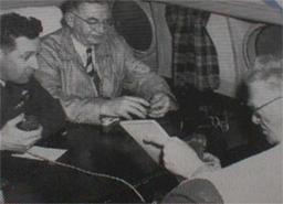 |
Photographed
while recording a description of
the flight to the geographic pole, March 29,
19S4,
for Leonard W. Brockington, right, first
chairman of the Canadian Broadcasting
Corporation.
The Honourable Brooke Claxton,
Minister
of National Defence, centre, and Keith
Greenaway
are looking on. This was the first
flight to the North Pole by a member of the
Cabinet of the Government of Canada. The
photograph was taken shortly after circling
the
Pole and on the way back to Resolute Bay.
[Photo, courtesy RCAF Archives] |
The multi-talented
Keith Greenaway was born in Victoria County, Ontario, in 1916. After attending
the Canadian Electronics Institute in Toronto, he joined the RCAF in 1940.
During World War II he trained navigators and wireless air gunners of the
British Commonwealth Air Training Plan.
From the mid-forties
into the sixties, Keith Greenaway continued to take advantage of the improving
capabilities of directional gyroscopes to develop further an accurate and
reliable system of aerial navigation in the polar regions of the Arctic.
Thereafter until he retired from the Canadian Armed Forces in 1971, Brigadier-General
Keith Greenaway served as Air Advisor to the Chief of the Air Staff of
the Royal Malaysian Air Force.
Greenaway has received
many awards and recognitions for his aerial navigational work in the Arctic.
These include the Thurlow Award in 1951 from the United States Institute
of
Navigation for his
contribution to navigational science, the McKee Trans-Canada Trophy in
1952 for contributions to Arctic flying, the Massey Medal in 1960 for outstanding
personal achievement and contributions to the development of Canada, induction
as a premier member in Canada's Aviation Hall of Fame in 1973, Companion
of the Order of Icarus for contributions to manned flight.
This dedicated Canadian,
who has made Arctic aerial transportation less complex, has been an editor,
author, coauthor and contributor to various international aerial publications.
In 1956 with Moira Dunbar he co-authored the prominently important Arctic
Canada from the Air.
A.J. Bauer
