
|
|
Bering, a Danish explorer, was in the service of Russia when he discovered the Bering Strait and Sea in 1728. In 1741 he discovered Alaska and traded with the First Nations peoples, collecting large numbers of sea otter pelts which could be sold for very high prices in China. For this reason Russia established trading posts in Alaska. Alaska remained Russian territory until it was sold to the United States in 1867. |
 View one of Bering's charts [51K]
|
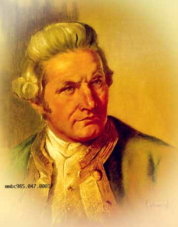
Cook's early training as an apprentice, seaman, and Master's Mate with a Whitby coal shipping company provided him with solid experience for assuming the responsibilities of captain in the merchant navy. However, in 1755 Cook chose to volunteer for the
Royal Navy as an able seaman. Why he chose to take on a lower position and endure the poor conditions and low pay is not clear, but perhaps he preferred the opportunities the Royal Navy offered in the area of exploration.
Cook was soon working on the east coast of Canada as Master charting the Newfoundland coastline extensively. While he was in eastern Canada Cook learned to adapt methods the Army's land surveyors were using to the traditional style of marine chart making.
The results were very accurate and successful. Cook had also made careful observations of the sun's eclipse which was of interest to The Royal Society in London because of the popularity of astronomy. For reasons such as these, Cook was an ideal candidate
to serve as captain on a series of voyages into the Pacific ocean where it was hoped that three main things could be discovered: whether or not a Great Southern Continent existed; what the distance was between the sun and the earth (by observing the
Transit of Venus from Tahiti); and whether or not a Northwest Passage existed in the Arctic that would link the Pacific ocean to the Atlantic. Cook made three well documented voyages into the Pacific (1766, 1772, and 1776), the last of which brought him to
Nootka Sound, British Columbia (1778), where he became the first European to walk these shores. Known for having the greatest respect for the peoples he encountered on his voyages, Cook unfortunately died the following year in the Hawaiian Islands in a
confrontation with the native peoples.
|
 Cook's ship Discovery (in the foreground) [19K]
Cook's chart of Friendly Cove [25K]
Cook's third voyage [21K]
Cook's ship Discovery (in the foreground) [19K]
Cook's chart of Friendly Cove [25K]
Cook's third voyage [21K]
|
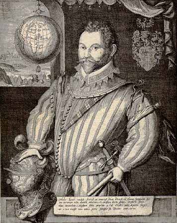
It is believed that Drake began his career with an apprenticeship at sea in coastal vessels. He later was involved in the slave trade and other 'unsavory' adventures. In 1577 he was employed by a syndicate headed by Queen Elizabeth I to make the first English circumnavigation of the world. Sailing in the Pelican, later renamed the Golden Hind, along with four other vessels, he completed this expedition in 1580. For his courageous voyage, Admiral Drake was made a knight. He was later appointed a Vice Admiral in the British navy and it was in this capacity that he is renowned for being instrumental in the defeat of the Spanish Armada. |
Drake's Golden Hind [44K]
Chart of Drake's voyage [52K]

|
De Fuca, a Greek pilot originally named Apostolos Valerianos, was employed by the Spanish to sail northward from Mexico and look for a northern passage from the Pacific to the Atlantic. In 1592 his exploration took him into the body of water now named after him - the Strait of Juan de Fuca. |
|
Galiano accompanied Valdes in 1792 in a Spanish expedition to the northwest coast. They sailed in the Sutil and Mexicana, met with Vancouver in the Point Grey/Burrard Inlet area, and, in a cooperative venture, charted the body of water between Vancouver Island and mainland British Columbia. |
The vessels Mexicana & Sutil [38K]
The ship Mexicana with the Sutil in the background [19K]

|
La Perouse commanded the French expedition of 1785, sailing in L'Astrolabe and La Bousole, and reached the west coast of Alaska in 1786. Intending to further the work of Cook and to establish some French claims to territory in the northwest, he made extensive surveys of the coastline between Monterey and Alaska. Nothing came of these efforts to establish sovereignty in this region and La Perouse and his two ships were lost in a storm in the Pacific in 1789. |
|
In 1784 Malaspina completed the circumnavigation of the globe. On an expedition in 1789 he sailed in the Atrevida for the Pacific Northwest claiming some of the territory for Spain. In 1791 the Atrevida and her sister ship visited Nootka Sound. On his return to Spain he counseled the government to occupy and settle the region rightly foreseeing the potential wealth of the area. However, due to political intrigue, his recommendations were rejected and he was imprisoned for his trouble. Malaspina Strait between Texada Island and the Sechelt Peninsula is named after him. |
The ship Atrevida [14K]
Spanish chart of Friendly Cove [36K]
|
Perez named Estevan Point after Martinez, his second-lieutenant on the Spanish expedition which reached British Columbian waters in 1774. Martinez led an expedition (along with Lopez de Haro) in 1788, confirming Russian intentions to occupy Nootka Sound. This led to Spanish settlement in Nootka in 1789 to officially mark Spanish sovereignty on the west coast of North America. Martinez seized three British ships at Nootka, aggravating tensions between the Spanish and British. This incident began a series of negotiations that eventually led to Spanish secession in this area. |
|
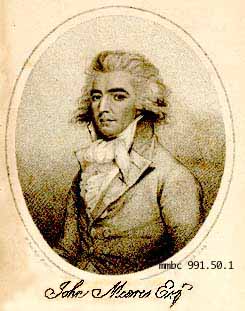
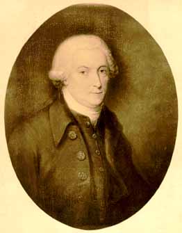
Born in 1756, Meares entered the navy in 1771 at the age of 15. He started his career on board the H.M.S. Cruiser and after seven years was promoted to lieutenant. Later promoted to commander, Meares is known for his exploits as a fur trader and the seizing
of his ships at Nootka. After several years of retirement, he died in 1809. Meares Island at the entrance of Clayoquot Sound is named after him. Meares was responsible for importing many Chinese labourers whom he used in the construction of dwellings and in the construction of the vessel 'Northwest America'. When his ships were seized by the Spaniards he had no means of returning the workmen. Whether he actually intended to do so is still debated. |
Launching the Northwest America [26K]|
|
Sailing in the Santiago, Perez reached the British Columbia coast in 1774 but did not go ashore. He was in contact with First Nations people north of the Queen Charlotte Islands and further south at Estevan Point where he traded with the Hesquiat people (a sub-band of the West Coast). |
|
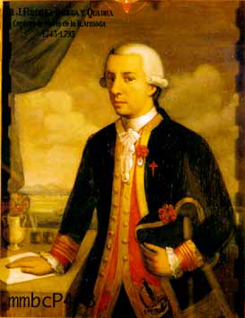
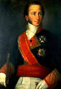
Quadra sailed north from Mexico and into British Columbian and Alaskan waters in 1775 and 1779. As Governor of Nootka he was present in 1792 to negotiate the terms of the 'Nootka Convention' with Vancouver. Soon after, Spain ceded to Great Britain and the Spanish garrison at Nootka was withdrawn in 1795. The amiable relationship between Quadra and Vancouver is well known and was demonstrated by Vancouver's choice in originally naming Vancouver Island 'The Island of Quadra and Vancouver'. |
Quadra's chart of Vancouver Island [23K]
|
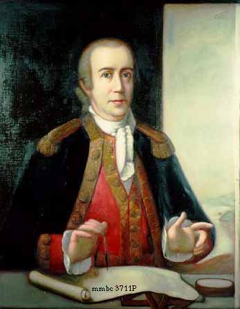
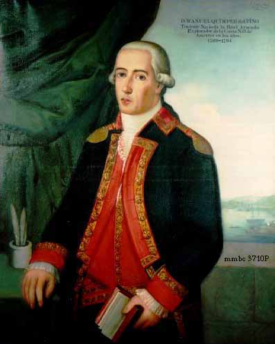
In 1790 Quimper sailed north to Alaska, and, in the recently seized British ship (owned by Meares and renamed the Princesa Real by the Spanish), explored the Strait of Juan de Fuca upon the order of Martinez. |
Quimper's chart of the Strait of Juan de Fuca [27K]
|
Valdes accompanied Galiano in 1792 in a Spanish expedition to the northwest coast. They sailed in the Sutil and Mexicana, met with Vancouver in the Point Grey/Burrard Inlet area, and, in a cooperative venture, charted the body of water between Vancouver Island and mainland British Columbia. |
The vessels Mexicana & Sutil [38K]
The ship Mexicana with the Sutil in the background [19K]
|
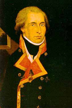
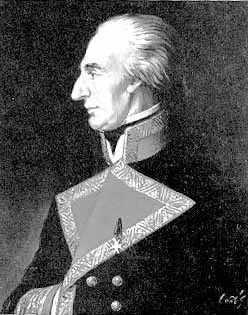
English navigator and explorer who began his career in the Royal Navy, serving under Cook on his second (1772-1774) and third (1776-1779) voyages. In 1791 he was appointed to command an expedition of discovery of the northwest coast of America, setting sail in the Discovery and the Chatham. He reached the Strait of Juan de Fuca in May of 1792. After surveying this area he moved on to Puget Sound where he made extensive surveys. This area is named after Lieutenant Peter Puget of the Discovery. Sailing north, Vancouver discovered that Vancouver Island was actually separated from the mainland, and that the body of water they were sailing in did not lead to a northwest passage. In the area of Point Grey and Burrard Inlet, Vancouver met with Valdes and Galiano, and they proceeded together sailing northward as far as Queen Charlotte Sound. Vancouver then sailed down the west coast of the island to accept secession documents from the Spanish who had occupied the territory since 1789. Vancouver is credited with completing the circumnavigation of Vancouver Island. His accomplishments are remembered in the naming of Vancouver Island and the city of Vancouver. |
Discovery aground in Queen Charlotte Sound [37K]
Sailing into Burrard Inlet [16K]
Vancouver's chart of Vancouver Island [43K]
Chart of Vancouver's route [23K]

![[English]](../simages/english.gif)
|

![[French]](../simages/french.gif)
|

![[Credits]](../simages/credit.gif)
|

![[Feedback]](../simages/feedback.gif)
|