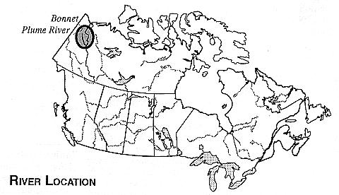
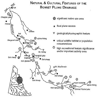
THE BONNET PLUME RIVER
YUKON TERRITORY
The Bonnet Plume River descends from the rugged Wernecke
Mountains to carve out a magnificent, wide valley and crosses a
lowland plain, heading west and north towards its confluence
with the Peel River. A wilderness area rich in natural
history, the Bonnet Plume basin features plentiful examples
of slip faults, rock glaciers, aretes, cirques and moraines,
which reflect an evolutionary history extending back to the
Late Pre-Cambrian period. Also significant for its human
history, the area has supported the subsistence activities of
the Tetlit Gwich'in of the Northwest Territories (NWT) and
the Nacho N 'y' ak Dun First Nation of the Yukon for
centuries. This traditional use of the valley's resources
continues today, alongside the wilderness recreational
activity of visitors. The Bonnet Plume is also recognized as
a superb recreational river and a significant component of
the Canadian Heritage Rivers System (CHRS). The diversity of
wildlife, vegetation and scenery of this expansive and
beautiful region provides an exceptional opportunity for
visitors to appreciate the character of the Yukon wilderness.
GEOGRAPHY
The Bonnet Plume River headwaters in the Mackenzie Mountains,
straddle the drainage divide which separates the Yukon and
the NWT. The river flows over 350 kms before joining the Peel
River, which flows northward across the Yukon/ NWT border to
the Mackenzie River delta. Nominated for inclusion in the CHRS
in 1993, the Bonnet Plume and its tributary rivers encompass
a total area of approximately 12,000 sq kms. A management
plan, expected for completion in 1996, is currently being
prepared for the watershed. This plan will address the
interests and concerns of all stakeholders within the area
and will utilize their experience and strengths to the
benefit of sound, long term, ecologically sensitive
management for the Bonnet Plume watershed.
The communities closest to the Bonnet Plume are significantly
removed from the river, and access to the basin is only by
aircraft. Due to its regular air and road connections with
the south, and the presence of air charter operations based
there, Whitehorse is the main entry point to the area. Mayo,
located on the Stewart River and with access from the
Klondike Highway, has a float plane base and air strip but
all air service is based in Whitehorse. Fort McPherson, a
common destination point for river travelers, offers limited
facilities and services. It is accessible both by air, from
Inuvik, NWT, and by road, via the Dempster Highway.
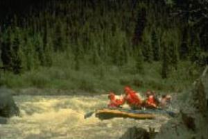
Rafting in the upper Bonner Plume River canyon
NATURAL HISTORY
Three mountain systems, the Mackenzies, Werneckes, and
Richardsons converge in the Bonnet Plume drainage area.
Extensive folding and faulting contributed to the area's
complex geologic history. The Bonnet Plume basin contains
some of the thickest and most extensive coal deposits in the
Yukon, and the entire drainage area has attracted interest in
its iron, lead-zinc, copper and uranium deposits. A
paleontological find near the mouth of the Bonnet Plume River
is of particular significance as it is the only discovery of
dinosaur bones in the Yukon. Vertebrae from the back of the
tail and a fragment of the fifth finger of the hand from a
duck-billed dinosaur were discovered along the south side of
the Peel River, between the mouth of the Bonnet Plume and
Wind Rivers.
During the earliest Laurentide glacial advance, ice covered
all the valleys of the Bonnet Plume area, and was continuous
across the divides. Extensive cirque development in the
Wernecke Mountains indicates strong alpine glaciation, and
other glacial landforms such as aretes, moraines and rock
glaciers are common. Continuing erosional forces create
hoodoos along the middle sections of the river and fluvial
processes result in extensive river braiding. One of the most
dramatic physiographic features of the area occurs just below
Bonnet Plume Lake, where a large rockslide has transformed
the valley, forcing the river to carve a canyon through the
massive deposit of rock.
As the river descends from its headwaters in the alpine zone
towards its confluence with the Peel, the vegetation changes
accordingly. In the upper reaches, the valley lies within the
tundra region, and although shrub birch and willow
communities occur in protected sites above the treeline, this
zone is also characterized by massive scree slopes which are
essentially devoid of vegetation. Open stands of black and
white spruce occupy the longer slopes and occasionally the
well-drained valley bottoms of the river's middle reaches.
The dominant ground vegetation includes moss and lichens,
usually with heath-like shrubs and sedge tussocks. In the
longer reaches of the valley, white spruce is dominant along
rivers and streams, in alluvial sites or on dry, upland
areas. Black spruce and larch occupy poorly drained sites
such as bog forest areas. Other tree species represented are
aspen, paper birch and balsam poplar or cottonwood.
The Bonnet Plume area contains three noteworthy vegetation
species: a community of tamarack near the mouth of Slats
Creek, an occurrence considered unusual at this latitude; a
rare vascular plant species, Papaver walpolei, which is
threatened in Alaska; and, a species of saxifrage, Boykinia
richardsonii, previously thought to be limited to an
unglaciated area of the northwestern Yukon.
The Bonnet Plume region is noted for its wildlife habitat and
supports large populations of sheep, caribou, moose and
grizzly bear. The watershed is home to the Bonnet Plume
caribou herd, one of the largest sedentary woodland caribou populations in the Yukon. The cottonwood/spruce forests and
lichen woodland areas of the valley are considered excellent
moose habitat.
A sizable sheep population inhabits the Wernecke Mountains,
and relatively high densities of grizzly have been reported
in the river area. Bird species include peregrine and gyr
falcon, eagles, ruffed grouse, rock ptarmigan, loons, ducks
and swans.
The lower Bonnet Plume River is considered sensitive and
valuable fish habitat, and a spawning and nursery area for a
number of fish species including Arctic grayling, slimy
sculpin, round whitefish and Dolly Varden char. Margaret Lake
and Bonnet Plume Lake contain such species as whitefish and
lake trout. The Bonnet Plume watershed also contains relic
fish populations. Twice during the Pleistocene glaciations,
the Peel River was diverted into the headwaters of the Yukon,
enabling aquatic organisms to transfer from the Yukon River
system to the Bonnet Plume and other parts of the Peel
drainage.
HUMAN HISTORY
The Nacho N 'y' ak Dun of Mayo, Yukon and the Tetlit Gwich'in
of Fort McPherson, NWT and their ancestors have used the
Bonnet Plume area continuously for thousands of years in
traditional subsistence activities of hunting, fishing,
trapping and gathering. Other aboriginal groups as well have
relied on the resources of the Bonnet Plume area,
particularly when the caribou were plentiful. The Wind and
Bonnet Plume Rivers have been important traditional travel
routes between Fort McPherson and the Mayo and Lansing areas,
for travel on foot or with dog packs.
After placer diggings were discovered on the Klondike River
in 1896, routes through the Peel River drainage, including up
the Bonnet Plume River and westward up Gillespie Creek, were
used by many parties traveling to the gold fields. Many of
these prospectors were also involved in trapping activities
in the Bonnet Plume area.
Early travelers were frequently dependent upon local people
for transport, guiding and help in emergencies. It is
reported that Andrew Flett Bonnetplume, the river's namesake
who lived along the river, was a Gwich'in chief and
interpreter for the Hudson Bay Company (HBC). Bonnetplume
assisted many travelers, who had been caught by winter on the
trail to Dawson, and the river was named after him for this
reason.
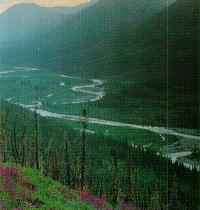
Forested slopes in the middle reaches of the Bonnet Plume River
RECREATION
As the Bonnet Plume flows from the high alpine area of the
Mackenzie Mountains to its junction with the Peel River at an
elevation 2,000 m below its source, the river passes through
a wide range of environments. This tremendous diversity
provides for an extensive variety of recreational activities.
The Bonnet Plume River stands out as one of the premier
whitewater wilderness canoe rivers in Canada. It is
technically challenging, particularly from just below Bonnet
Plume Lake to the junction with Knorr Creek, where Class II
and III rapids are frequent with isolated locations of Class
IV and V. In fact the river can be considered potentially
dangerous, dropping more than three metres per kilometre in
the upper reaches. The river trip to Fort McPherson is
generally considered only suitable for canoes or kayaks, as
potentiel problems with winds and slower current in the
longer reaches of the Peel into Fort McPherson, make rafting
more difficult. The Bonnet Plume River offers river travelers
excellent opportunities for related recreational activities,
as excellent camping locations and opportunities for scenic
day-hikes, particularly in the alpine areas, are readily
accessible from the river.
In the upper reaches of the valley, in the alpine zones and
around many of the creeks and small alpine and subalpine
lakes, hiking and camping opportunities are superb. Although
at longer elevations, in the creek bottoms, hiking is
sometimes impeded by thick shrubs or birch and willow growth,
ridge hiking and scrambling possibilities in the glaciated
summits of the Bonnet Plume headwater area are excellent. As
with all wilderness areas of the Yukon, careful attention
should be paid to grizzly bear safety when hiking in these
areas. Mountain climbing potential is also significant in the
area, and peaks such as Mt. McDonald and Mt. Gillespie, in
the headwaters along the Yukon/NWT border, present an
interesting and rewarding opportunity for climbers.
Opportunities for recreational pursuits focusing on the
natural environment, such as wildlife viewing, photography,
nature study and scenic appreciation are also significant.
Hunting activity has a long history in the Bonnet Plume area,
and currently big-game hunting operations attract
international clientele. The wilderness qualities of the area
emanate from the dramatic scenery of the valley and the
special features that create its appeal. Broad, expansive
views, a diversity of plants and landforms, interesting
landscape formations and extensive wildlife populations
provide a remarkable backdrop for wilderness recreational
activity.
VISITOR INFORMATION
Access:
Access to the headwaters of the Bonnet Plume Basin is by air,
either directly from Whitehorse, or through the community of
Mayo. Besides returning to these communities, river travelers
have the option of proceeding down the Peel River to Fort
McPherson, NWT. The typical river trip along the main segment
of the Bonnet Plume River itself is suggested to take 7 to 9
days, while the total trip length to Fort McPherson is
estimated to be 14 to 18 days. Trip duration is determined by
the choice of access points -- small lakes adjacent to the
river accessible by float plane. Shorter segments are
possible but typically do not provide the same range of
recreational activity and experience.
Accommodation and Services:
Whitehorse (pop. 18,000), is a major centre and capital city
of the Yukon, offering a wide range of services. Hotels,
restaurants, retail outlets and a full range of outfitting
and guiding services, specialty shops and cultural
entertainment are all available to the visitor. Whitehorse is
easily reached by road or by air from the south, and operates
as the base for air charter operations for visitors.
Mayo (pop. < 500), although closer by air to the Bonnet Plume
basin, does not offer the visitor the extent of services and
facilities available in Whitehorse. Accommodation and basic
services such as food, restaurants, camping supplies and
fuel, are available. The community has a float plane base and
an air strip, but all service is based in Whitehorse.
Fort McPherson is similarly a small community providing only
accommodation and basic services to visitors. It is, however,
located along the Dempster Highway resulting in road access,
as well as regularly scheduled air service from Inuvik. NWT.
Topographic Maps:
The Bonnet Plume River is covered by the National Topographic
Series 1:250,000 scale maps: 106 B (Bonnet Plume Lake), 106 C
(Nadaleen River), 106 D (Nash Creek), 106 F (Snake River),
106 E (Wind River). Maps for the portion of the Peel River
from the Bonnet Plume River junction to Fort McPherson are:
106 K (Martin House), 106 L (Trail River), 106 M (Fort
McPherson). 1:50,000 maps are not required for river
recreation trips.
Maps may be obtained from: Canada Map Office, 615 Booth St.,
Ottawa, Ont. K1A 0E9 (613-952-7000); or Northern Affairs
Program, Geological Services, 200 Range Rd., Whitehorse,
Yukon Y1A 3V1 (403- 667-3100).
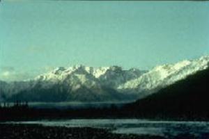
The Rackla Range of the Wernecke Mountains
FURTHER INFORMATION
Services, Permits & Regulations: Yukon Visitor Reception Centre, Alaska Highway, Whitehorse,
Yukon Tel. 403-667-2915; Yukon Dept. of Renewable Resources,
P.Q. Box 2703, Whitehorse, Yukon Y1A 2C6 Tel. 403-667-5221;
FAX: 403-667-2691.
Tourist Information Accommodation, Air Charters, Outfitters: Tourism Yukon, P.Q. Box 2703, Whitehorse, Yukon, Y1A 2C6 Tel.
403-667-5340, FAX 403-667-2634; Tourism Industry Assoc. of the
Yukon, 203-208 Main St., Whitehorse, Yukon, Y1A 2A5 Tel. 403-
668-3331; FAX: 403-667-7379.
Canadian Heritage Rivers System: Member, CHRS Board, c/o Yukon Renewable Resources (see
address above); or, Secretary, CHRS Board, Ottawa, K1A 0M5
Tel. 819-994-2913.
Additional Reading:
Brown, Dolores Cline. 1989. Bonnet Plume's Gold. Klein
Publishing Company. Mayo, Yukon.
Finkelstein, Max. "Postcards from the Bonnet Plume". Kanawa.
Magazine of the Canadian Recreational Canoeing Association.
Spring, 1993. Hyde Park, Ont.
Geological Survey of Canada. 1977. Paper 76-8 The Geology of
the Bonnet Plume Basin. Yukon Territory. D.K. Norris & W.S.
Hopkins Jr.
Madsen, Ken and Graham Wilson. 1989. Rivers of the Yukon: A
Paddling Guide. Canada: Primrose Publishing.
Pielou, E.C. 1991. After the Ice Age: The Return of Life to
Glaciated North America. Chicago: University of Chicago
Press.
Voyages: Canada's Heritage Rivers - Lynn E. Noel, editor. Published by Breakwater Books of Newfoundland and sponsored by QLF/Atlantic Centre for the Environment. Newfoundland orders
toll free: l-800-563-3333, Canadian orders and inquiries outside Newfoundland toll free: 1-800-387-0172, U.S. orders and inquiries toll free: 1-800-805-1083. Discount available from Canadian River Management Society, Tel. 819-994-3011.
Written by: Bruce Downie and PRP Associates
Edited by: Michael Greco
Photos Courtesy of Bruce Downie and Max Finkelstein
Maps Created by: Bruce Downie and PRP Associates
Last Revised:1995