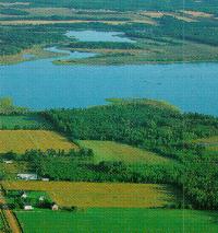
Looking east at the mouth of the Hillsborough from above Fort Amherst - Port La Joye.
Human populations originating from various European sources over the past 275 years, adapted
well to the diversity of an estuarine waterway. Attracted to its life sustaining qualities humans
have at various times harvested oysters, quahogs and mussels; dyked and harvested wetlands;
played in and along the river; built large sailing vessels; and used it as a link to local and foreign shores.
In recognition of its importance to our human heritage and because of its outstanding recreational
values, the Hillsborough was nominated to the Canadian Heritage Rivers System in 1994. The
nomination was sponsored by the Province of Prince Edward Island in partnership with the
Hillsborough River Association - local citizens concerned for the river's future and appreciative
of its past. Not forgotten are the days when people homesteaded by the river and used the
steamer service in summer and the frozen estuary in winter.
The lengthy estuary features a "drowned river" corridor which once had a broad flood plain before rising sea levels more permanently submerged the area.
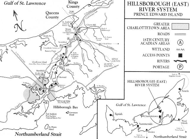
The landscape is flat to gently rolling. The highest watershed point is only 250 feet in an area renowned for its fresh water supply from ground springs. From Charlottetown to Glenfinnan
Island is a very wide estuary, narrowing to roughly 1/2 km. in width at this 5.6 ha island 10 km. from Charlottetown. The river narrows a second time at Mt. Stewart to several metres. Fed by
many springs it is only a few metres wide in the Cherry Hill area.
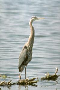
Hundreds of nesting pairs of Great Blue Heron like the relative seclusion of Glenfinnan Island near the convergence of the Glenfinnan and the Hillsborough rivers. It is the furthest inland of PEI's 20 offshore islands. Wildlife viewing is especially rewarding from this point up river and on the tributaries to the south. Where the Hillsborough flows into the Charlottetown Harbour, a common tern colony nests on the bridge piers abandoned by humans more than 30 years ago. Both these colonial nesters provide opportunity for natural heritage appreciation.
Designated natural areas exist within the drainage basin: Royalty Oaks, a 4 hectare mature red oak stand, believed to be the only one of its kind in the province, is protected, managed and interpreted in East Royalty. This community and the Island Nature Trust co-manage the site. A wetland on the Johnstons' River is crown owned and protected under the Natural Areas Protection Act.
Other details of interest include the 57 rare vascular plants within the watershed (25 are, not surprisingly, wetland species) and the presence of several shore bird species on the extensive tidal flats. A variety of salt and fresh water fish inhabit the waterway including brook trout, striped bass, smelt, mackerel and eel.
The single most important feature of the natural heritage of the river is its variety of wildlife due
principally to the diversity of habitat. The impact of humans on the natural heritage of the watershed is significant. Like so much of Prince Edward Island no unaltered area remains.
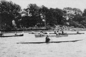
Water related activities include canoeing and kayaking, access being frequent along the river.
Canoe and kayak excursions are available out of Charlottetown; hiking and camping may be
included in some outings. Most sailing has been restricted to Charlottetown Harbour by low
clearance and a strong current under the Hillsborough Bridge. Once negotiated, navigators
must carefully follow the channel to Mt. Stewart.
Nature appreciation possibilities include viewing from a distance sites such as the Glenfinnan
Island Great Blue Heron colony; watching bald eagle and osprey fishing; and bird watching on
overland trails.
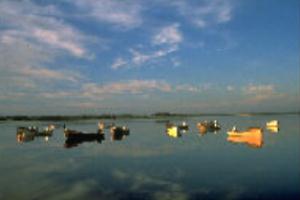
Fishing and hunting are popular. The estuary supports a variety of shellfish and finfish species.
Brook and rainbow trout and occasionally striped bass are popular with anglers. Hunting for
waterfowl is outstanding in the watershed, especially within the nominated area. The floodplain
landscape features estuaries, fresh water lakes and ponds and provides excellent feeding and migrating grounds for various species. Blue-winged teal and brant join black duck and Canada goose as the most common species.
Trails and routes reflect the historical development and the natural features of the river corridor
and offer excellent recreational opportunities over easy terrain. "Routes for Nature and Health"
in the Charlottetown area incorporate most of the abandoned rail right-of-way. The
Confederation Trail covers 77kms. from Mt. Stewart to Elmira. Other notable trails include
those at the Auburn Demonstration Woodlot and the Royalty Oaks natural area.
The Hillsborough is alive with human heritage appreciation opportunities. There are festivals
and events, museums and sites of cultural importance. The Friends of St. Andrews recently
accomplished an amazing feat taking the burned out shell of Prince Edward Island's first college
chapel from Charlottetown back to its original home at St. Andrews, above Mt. Stewart. Over
100 years earlier the chapel was moved by dozens of horses down the frozen river to
Charlottetown. Today it is a cherished heritage building of the Hillsborough, host to lectures and
concerts.
Few cultural artifacts remain from prehistoric Mi'Kmaq, their ancestors or the French along "La Grande Riviere". The French were the first Europeans to occupy the area on a continuous basis
beginning in 1720 at Port La Joye guarding the mouth of the river. Tragedy struck at the hands of the British in 1758. Most of the Island population of 5,000 was removed from their homeland,
including the rich marshlands of the Hillsborough which had attracted the experienced Acadians a few short years earlier. Archaeological work at Fort Amherst/ Port La Joye National Historic
Park and survey work along the river corridor are contributing to the understanding of life under French rule.
Under the British flag there arrived two large groups of settlers. The Glenalladale settlers (Catholic highlanders) landed first on the north side of the river in 1772 and the Monaghan Irish
arrived on the south side 58 years later.
The river has always served as "highway". It was travelled as late as the 1960's. The frozen estuary was used when severe winter snowstorms would block roads for days. Roads parallel to
the river connected the various rural communities all within easy distance of a wharf. More than 500 vessels were built along the Hillsborough, many out of the four shipyards now barely visible where the river narrows at Mt. Stewart. Where the river narrows at Glenfinnan Island the French and English are thought to have clashed in the 1750`s. A "battery" guards the spot.
The agricultural and fishery (especially oyster) landscapes of Prince Edward Island are well represented on the Hillsborough. At its mouth. the meeting place of the North, the West and the East rivers is Charlottetown. In September of 1864 the Fathers of Confederation met here, an important first step in the formation of Canada. A festival marks the occasion every September at the mouth of the Hillsborough.
Tourist Information: 1-800-463-4PEI, or write Visitor Services, Econ. Development & Tourism, Box 940, Ch'town, PEI, C1A 7M5
Sport Fishing Regulations: Fish and Wildlife, Environmental Resources, Box 2000, Ch'town, PEI, CIA 7N8 Tel. 902-368-4683.
Hiking Trails: Island Trails, c/o Box 265, Ch'town, PEI, C1A 7K4 Tel. 902-894-7535.
Provincial Parks: Visitor Services, Econ. Development Tourism, Box 940, Ch'town, PEI, CIA
7M5 Tel 902-3684444.
National Parks: Parks Canada, Historic Properties, Upper Water St., Halifax NS, B3J 1S9. Tel 902-426-3436; National Parks, Canadian Heritage, 2 Palmer Lane, Ch'town, PEI, C1A 5V6 Tel 902-672-6350.
Canadian Heritage Rivers System: National Manager, Canadian Heritage Rivers Board, Ottawa, K1A 0H3 Tel 819 994-2913.
Canadian Heritage Rivers on PEI: Project Development Officer, Econ. Development & Tourism, Box 2000, Ch'town, PEI, CIA 7N8 Tel 902-368-4275.
Hillsborough River Assoc. Box 22003, Ch'town, PEI, C1A 9J2 Tel 902-892-5653 Fax 902-628-6331.
Guides, Outfitters and Lodging: Visitor Services, Econ. Development & Tourism, P.O. Box 940 Ch'town, PEI, CIA 7M5. Phone (902) 368-4444.
Clark, A.H; Three Centuries and the Island: A Historical Geography of Settlement and Agriculture in Prince Edward Island. Canada, Univ. of Toronto Press, 1959.
Day, R. and P.M. Catling; The Rare Vascular Plants of Prince Edward Island; Syllogeus No. 67, Canadian Museum of Nature, 1991.
Environment Canada; Water: PEI's Most Precious Resource, Surface Water Program, Fed. and Prov. Environment Depts. 1990.
Johnstone, W; Travels in Prince Edward Island, Gulf of St. Lawrence, North America in the years 1820-21, published 1824 by J. Robertson and McIsaac, L; In The River Flows On, Lemark Publ., Ch'town, PEI 1992.
Noel, L.E; ed. Voyages: Canada's Heritage Rivers, Breakwater Publ., Prod. by QLF/Atlantic Centre for the Environment, Nfld. 1995.
PEI Museum & Heritage Foundation; The Island Magazine, 1976 - present, various topics, publ. semi-annually. 2 Kent St. Ch'town, PEI C1A 1M6.
Pigot, F.L; John Stewart of Mt. Stewart: A History of Mt. Stewart, PEI Heritage Foundation, Commemorative Series #2, 1974.
| More Information | Return to CHRS homepage | Table of Contents |
|---|