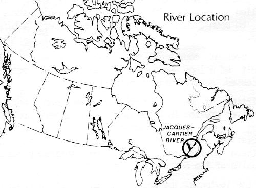
THE JACQUES-CARTIER RIVER
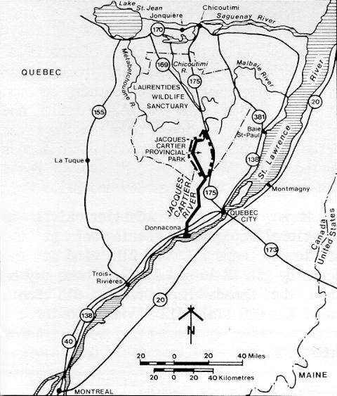
QUEBEC
Protected for most of its length by Jacques-Cartier Provincial Park in the north and
by other publicly owned lands to the south (77% of the shoreline is publicly owned),
the Jacques-Cartier River has been nominated to the Canadian Heritage Rivers
System for its outstanding beauty, its enormous recreational potential, and for its
heritage value in representing the natural and historical evolution of Quebec.
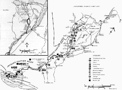
The 177 kilometre-long Jacques-Cartier River is located in south-central Quebec
and is easily accessible for nearly all of its length, from its source in the Laurentian
Mountains midway between Chicoutimi and Quebec, to its mouth 30 kilometres
west of Quebec City.
The Jacques-Cartier River
GEOGRAPHY
The Jacques-Cartier river basin comprises two distinct parts: an upper section in
Jacques-Cartier Provincial Park in the Laurentian Mountains, and a lower section
comprising the southern edge of the Shield and the St. Lawrence Lowlands.
Lower Section: The lower section extends from Donnacona to Tewkesbury and is
mostly protected by large blocks of publicly and privately held land. The river banks
here are partially wooded and moderately populated. A regional population of about
25,000 is concentrated in six villages along the river: Donnacona (5,900), Pont-Rouge (3,850), Sainte-Catherine (3,590), Shannon (3,620) Saint-Gabriel-de-Valcartier (3,160) and Tewkesbury (3,690).
Upper Section: The upper section extends from Tewkesbury to the river's
headwaters. This wooded and uninhabited part of the Laurentians is protected by a
provincial park and by a wildlife reserve. The former, Jacques-Cartier Provincial
Park, comprises 670 square kilometres and includes the deepest part of the river's
valley.
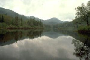
Scenic view of the upper Jacques-Cartier River
NATURAL HERITAGE
Of outstanding, indeed spectacular, beauty in Jacques-Cartier Provincial Park, the
river also displays the geological evolution of southern Quebec. The primary
feature of the valley is its representation of the two main geological structures
associated with Quebec: the Canadian Shield to the north and St. Lawrence
Lowlands in the south.
In the north, for 160 kilometres from its source to the village of Pont-Rouge, the
river crosses the Grenville Province, the youngest of the Canadian Shield
'provinces' at 955 million years of age.
South of here, for about 17 kilometres, the river crosses the St. Lawrence
Lowlands, which are composed of lower Palaeozoic sedimentary rocks about 500
million years old. These limestone and clay shales can be seen clearly at the
picturesque Déry fishing site.
The present course of the Jacques-Cartier is the result of a long evolution of many
geomorphological processes, some of which continue today.
Uplifting of the Laurentian Mountains began a period of river erosion in which deep
valleys were created along geological weaknesses. The Quaternary glaciations
then created the broad valleys of the northern part of the river and the fertile glacial
deposits of the St. Lawrence Lowlands.
In the lowlands, the melting of the glaciers created the vast inland Champlain Sea
around which deltas were formed by streams and rivers. With the gradual draining
of this sea, the Jacques-Cartier cut into the marine sediment left behind, creating
river terraces which can be seen near Pont-Rouge and Sainte-Catherine. At this
time the present course of the river was determined and the spectacular gorge at
Déry, which is 1,500 metres long and several dozen metres deep, was gouged out
of the limestone.
Vegetation: Vegetation evolved progressively after the glaciation: tundra gave way
to taiga scrub, then taiga gave way to boreal forest, and finally deciduous forest
flourished. The Jacques-Cartier valley contrasts sharply with barren glacial valleys
to the north and west. Its vegetation is diverse and lush, with remarkable intrusions of deciduous species into the northern coniferous forests.
Wildlife: The Jacques-Cartier valley supports wildlife typical of mixed forests of
eastern Canada. There are 23 species of mammal including the moose, black bear,
racoon and white tailed deer. There are also 104 known species of birds including
the osprey and American kestrel, and 16 species of fish among which are the
speckled trout, which is particularly abundant, and the Atlantic salmon, which is
being reintroduced.
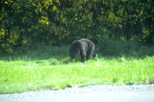
A Black Bear
HUMAN HISTORY
Although of somewhat secondary historical importance, the Jacques-Cartier River
portrays certain elements which are valuable in the understanding of the history
and prehistory of Quebec and Canada.
Prehistory: It seems the valley has a rich prehistory having been a link between two
important regions: the St. Lawrence valley and the Lac St.-Jean area. It is thought
that native peoples used the valley as a communication route and for hunting and
fishing for about 7,000 years. Over 50 sites have archaeological potential.
History: The banks of the St. Lawrence were successively occupied by Iroquois,
Algonquin and Europeans in the 17th century, at which time the interior was being
exploited by Attikamek and Montagnais Indians. It is known that the Hurons from
Lorette divided this back country, which was not then settled by Europeans, with
the Algonquin nations. The enigmatic 'Jesuit trail', linking Quebec and Lac St.-Jean
at this time, seems to have followed in part a trail of these Indian hunters.
The development of the Jacques-Cartier valley is an eloquent illustration of the
major periods of colonisation in Quebec. At the river mouth, the seigniorial pattern
of the land subdivision, the place names, and the architecture evoke the French
period. After the conquest of 1759, English settlers arrived and established the
system of townships. The cantons of Stoneham and Tewkesbury are good
examples of this. With the arrival of more colonists, industry began to develop.
By the early 19th century, lumbering and agriculture flourished. Along the river,
several saw mills and grist mills were constructed. At the same time, sport fishing
for salmon reached its heyday, to the extent that a law was passed in 1854
protecting the species. However, in spite of this, salmon became increasingly rare,
disappearing completely with the later construction of dams and the industrial use
of the water.
Commercial activities in the river valley until the 1970's consisted of lumbering in
the back country, and the construction of several hydro-electric dams. A
reawakening of public awareness of the valley's heritage value led to the creation
of Jacques-Cartier Provincial Park in 1981.
Major historic sites:
- The remnants of Fort Jacques-Cartier at the confluence of the Jacques-Cartier and
the St. Lawrence evokes the last but one point of resistance to the English
conquest. It is also one of few remaining earth and stone fortifications of the Seven
Years War;
- Allsopp Manor, dating from the mid-18th century is a designated historic site. It
attests to the economic enterprise of its owner and the region at the end of the
century, George Allsopp, who was the most important producer of flour in Lower
Canada;
- Déry House, built in 1804, with its toll bridge and salmon holes, demonstrates the
popularity of salmon sport fishing on the Jacques-Cartier at the beginning of the
19th century;
- Marcoux Mill, which was built in 1870 and recently restored, is an example of the
many grist mills once located along the river in the 19th century.
RECREATION
The Jacques-Cartier is located less than an hour from Quebec City and annually
attracts thousands of fishermen and outdoor enthusiasts. It offers a wide range of
activities, of which by far the most popular are fishing and boating.
Fishing: Atlantic salmon is now the subject of a restoration program which aims to
reopen salmon fishing between Donnacona and Pont-Rouge in the summer of
1990. Until then, speckled trout will continue to be the popular species for
fishermen, although brown and rainbow trout, pike and walleye can also be caught.
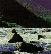
River Touring: The Jacques-Cartier River is well known beyond Quebec for its
canoeing and rafting. Each year, a large number of visitors make the trip, canoeing
and camping at serviced sites within Jacques-Cartier Provincial Park. Although of
secondary importance, there are five other canoe routes totalling 33 kilometres
which are heavily used between Donnacona and Tewkesbury. River running using
inflatable rafts is also increasingly popular.
Other Activities: Several other activities which make use of the opportunities
provided by the outstanding natural environment are pursued along the river.
These include rock climbing, bicycle touring, hiking, cross-country skiing,
picnicking, and nature observation and interpretation.
VISITOR INFORMATION
Jacques-Cartier Provincial Park: Before exploring the river, visitors are
encouraged to make use of the visitor reception centre in Jacques-Cartier
Provincial Park. Here they will receive a warm welcome, and the information
available will allow them to take full advantage of their stay. Planned interpretation
programs include permanent exhibits, audio-visual shows, guided tours, and
various demonstrations.

Visitor reception and interpretation centre in Jacques-Cartier Provincial Park
From May to October, the park provides visitors with facilities and services for
camping, hiking and cycling, canoeing, canoe-camping, climbing and picnicking. At
the visitor reception centre it is possible to rent equipment for the park's outdoor
activities. Introductory canoeing courses are offered, and a minibus service for
renters and their equipment is available.
In the winter, the park is open for cross-country skiing (on ungroomed trails), and
for ice climbing, for which permits are required. Visitors wishing to make trips longer
than one day are also required to make reservations.
Beyond the Park: South of the provincial park, a number of municipal parks provide
river access, opportunities for nature observation, picnic sites, hiking and cross-
country skiing. In addition, five interpretation centres at different locations provide
information about the region. Rafting trips are operated at Saint-Catherine and
Tewkesbury by private companies.
Accommodation: In the provincial park, campsites and chalets are available. To the
south, Donnacona, Pont-Rouge, Sainte-Catherine, Saint-Gabriel-de-Valcartier, Stoneham and Tewkesbury provide complete restaurant and lodging
services.
Access: Access to the northern section of the river is by Highway 175, via the
provincial park. From Quebec City, visitors can reach the southern section via
Highway 40. Roads from Brule, Montcalm and Dublin, and Route 369, provide
access to the river corridor between Donnacona and Shannon, where access is
interrupted by Valcartier Military Base. Tewkesbury is accessible by routes 369 and
371.
Topographic Maps: The Jacques-Cartier River is covered by National Topographic
Series maps at the 1:250,000 scale by maps 21L and 21M, and at the 1:50,000
scale by 21L/12-14 and 21M/3. These may be obtained from the Canada Map
Office, 615 Booth Street, Ottawa, K1A 0E9 (Tel. 613-995-4510).
FURTHER INFORMATION
The Canadian Heritage Rivers System: The Secretary, Canadian Heritage Rivers Board, Ottawa, Ontario, K1A 0H3 .
Jacques-Cartier River and Provincial Park:
Quebec Ministry of Recreation, Fish
and Game, Outdoor Recreation and Parks Branch, 150, Saint-Cyrille East, 16th
Floor, Quebec City, Quebec, G1R 4Y3.
Additional Reading:
- Ted Mosquin, Special Bulletin: a Supplement to Nature Canada, Volume 1, Oct-Dec 1972.
- Fédération Québecoise du Canot-Camping, Quebec Canoe Routes Map (Les percours conotables du Québec), n.d. Available from F.Q.C.C, 4545 Ave. Pierre de Coubertin, Box 1000, Station M Montreal, H1V 3R2.
- Government of Quebec, Canadian Heritage Rivers System, Nomination of the Jacques Cartier River, Ministry of Recreation, Fish and Game, 1987.
- Voyages: Canada's Heritage Rivers - Lynn E. Noel, editor. Published by Breakwater Books of Newfoundland and sponsored by QLF/Atlantic Centre for the Environment. Newfoundland orders
toll free: l-800-563-3333, Canadian orders and inquiries outside Newfoundland toll free: 1-800-387-0172, U.S. orders and inquiries toll free: 1-800-805-1083. Discount available from Canadian River Management Society, Tel. 819-994-3011.
Written and edited by: Michael Greco with the assistance of the Quebec Ministry of Recreation, Fish and Game
Photos Courtesy of Pierre Pouliot and Parks Canada
Maps Created by: Diamentino Batista
Last Revised:1988