The Kazan River
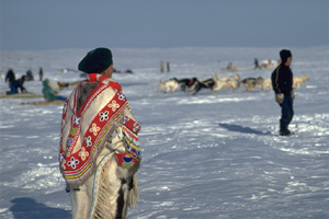
The Kazan River flows through the cradle of Caribou Inuit culture. In the heart of the barrenlands of Nunavut, the river lies on the migration route of the 320,000 strong Kaminuriak caribou herd, the largest movement of land mammals in the world. When glacier ice retreated some 5,000 years ago, Inuit came seasonally from the Hudson Bay coast to hunt caribou. In the late 18th century, they began to stay year-round along the Kazan and Thelon rivers, evolving a lifestyle unique among Inuit cultures.
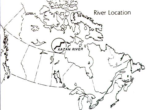
The Kazan rises near Kasba Lake, close to the northern border of Saskatchewan, then flows northward for 850 km to its mouth at Baker Lake, which in turn drains through Chesterfield Inlet into Hudson Bay.
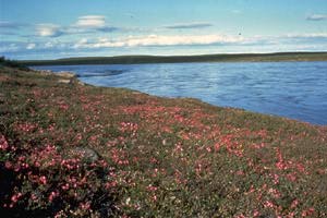
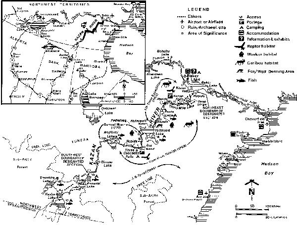
Its drainage area, which includes 5,000 km2 in Saskatchewan and northern Manitoba, totals 71,500 km2. The river flows through a transitional area of boreal forest and treeless tundra, but the 615 km designated section, from the outlet of Ennadai Lake to Baker Lake, is beyond the limit of continuous trees. At the river's mouth is a large, 7 km-wide delta.
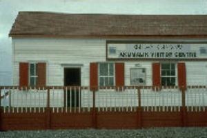
The Inuit community of Baker Lake, located on the lake's northwest shore, is at the geographic centre of Canada, 1500 km north of Winnipeg and 900 km east of Yellowknife. Although inaccessible by road, Baker Lake provides accommodation, food, supplies and outfitting services among the best available in the far
north, and offers traveIlers the unforgettable experience of modern Caribou Inuit life.
Signs of the Caribou Inuit and the people who came before them are everywhere along the river, evocative of a time when they lived entirely off the land. Dene and Inuit ancestors used the river during summer for more than 5,000 years, retreating to the treeline or the coasts for the rest of the year.
In the 18th century, the Dene use of the river declined substantially, while the local Inuit - the first generation Caribou Inuit - began living on the river year-round, when they discovered that they could harvest enough caribou to last throughout the winter. They evolved into three distinct groups: the Ahiarmiut living south of Angikuni Lake; the Harvaqtormiut north of Yathkyed Lake; and the Padleimiut, south of the lake, between the other two groups. In his late 1800's diary, pioneer Christian missionary, Father Alphonse Gaste recorded peaceful celebrations between the Dene who used the river and the Caribou Inuit who lived there.
The Kazan was unmapped until J. B. Tyrrell, the first geologist on the river, canoed from its headwaters to Forde Lake in 1894. His name was given to the east arm of Yathkyed Lake, Tyrrell Arm, and, to the now-diminished postglacial sea in the Hudson Bay depression, the Tyrrell Sea. During his trip, Tyrrell visited 39 tents housing at least 500 people along the Kazan. Every campsite had caribou meat drying on racks or cached for the winter.
The Fifth Thule Expedition of Knut Rasmussen explored the river from 1921-24. Expedition anthropologist Kaj Birket-Smith, was the first to describe the Caribou Inuit culture in Rasmussen's 1930 Report of the Fifth Thule Expedition.
The most recent study expedition on the Kazan was the 1988 Operation Raleigh. This international youth education, research and exploration program travelled 500 km of the river in 7 weeks and identified 186 archaeological sites along the river.
In its upper reaches, the Kazan flows through transitional boreal forest and tundra. Near the outflow of Ennadai Lake, the forest has thinned to sparse black spruce and tamarack. Rarely more than a metre or two high, these isolated conifers are stunted by harsh winds and dry summers.
In the river's middle and lower reaches, the riverscape varies from rocky hills to plains, but is unmarked by eskers or moraines, a remarkable characteristic of the region's creation: the Kazan was not at the edge of the glacial icesheet that covered the area, but at its centre, under the Keewatin Ice Divide for much of the Wisconsin Glaciation. The ice was thickest here, spreading east and west, and it remained here longer than at any other place in mainland Canada. Greatly depressed by the weight of the ice, the land is now "rebounding" at one of the highest rates in the world - more than half a metre a century.
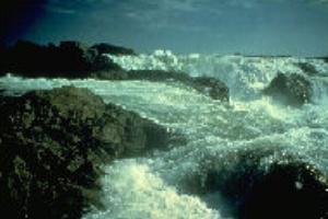
For most of its course, the river cuts through a distinctive rocky landscape, the Kazan Uplands. The topography varies from lush tundra to barren rock, from gently rolling hills to steep cliffs and from calm lakes to swift-water narrows and imposing waterfalls. Notable features on the river include:The Three Cascades, a series of 5 to 7 metre waterfalls between Angikuni Lake and Yathkyed Lakes, and the beautiful Kazan Falls, where whitewater drops 25 m then rushes for 2 km downstream through a red sandstone gorge. Along the portage above the falls, is a cairn which has been used since 1973 as a repository for messages from river travellers.
The Kazan's Canadian Heritage River status is partly based on its outstanding wilderness recreation focus:
Canoeing and Kayaking: Local Caribou Inuit still travel, hunt and fish on the Kazan. Today, for 6 to 8 weeks, July to September, perhaps 20 recreational canoeists also travel the river each year. But even in July, ice can force paddlers to wait for break-up. Yathkyed Lake is called 'Hikulijuaq' in Inuktitut, meaning "the great ice-filled one". Water levels and ice conditions change from year to year, depending on snowfall and the timing of spring break-up.
Fishing : Fishing for Arctic grayling and lake trout is excellent along virtually any stretch of river. A Northwest Territories fishing license is required and can be obtained from stores and government offices in the territories, or by writing to the Department of Renewable Resources, Box 1320, Yellowknife, X1A 2L9.
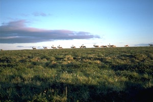
Wildlife Viewing: Myriad caribou trails cross the tundra, and the long twilight hours of summer are often filled with the distinctive clicking of caribou ankle bones, giving rise to their Inuit name, 'tuk-to'. As well as caribou, travellers often see muskox, particularly between Yathkyed and Thirty Mile lakes. Much smaller creatures, like the Arctic ground squirrel are common and bird watching is excellent. Birders enjoy many species rarely seen in the south: Arctic terns, tundra swans, snowy owls and ptarmigans.The Kazan and Kasba Lake both take their names from the Dene word for "ptarmigan".
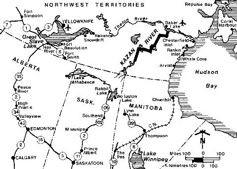
Access: Access to the Kazan is usually by chartered aircraft from Baker Lake or from Lynn Lake and Churchill, Manitoba. Baker Lake is connected to the south by scheduled airline from Churchill and Winnipeg and Lynn Lake is serviced through
Winnipeg. The closest road and rail access ends at Lynn Lake and Thompson, Manitoba. It is also possible to paddle to the Kazan from Lynn Lake,
beginning near town at Reindeer Lake, up the Cochrane River, then portaging over the Kazan watershed, but the trip is very long and the canoeing season, short. Canoeists therefore prefer to arrange floatplane drop-off on Kasba or Ennadai lakes. To end the trip, pre-arranged air charter pick-up is possible from many
points along the route. Most travellers, however, paddle directly to Baker Lake.
Tour operators in Baker Lake also offer day trips and flight-seeing tours on the Kazan. The l00 km trip to Kazan Falls from Baker Lake by charter floatplane or motorized freighter canoe is quite spectacular.
Topograghic Maps: The Kazan is covered by National Topographic Series 1:250,000 scale maps: 56D (Baker Lk), 55M (Macquoid Lk), 65P (Thirty Mile Lk), 65I (Ferguson Lk), 65J (Tulemalu Lk), 65K (Kamilukuak Lk), 65F (Ennadai), 65C (Ennadai Lk) and 65D (Snowbird Lk). For research purposes, 1:50,000 scale maps are also available. The maps may be obtained from: Canada Map Office, 615 Booth Street, Ottawa K1A OE9 (613-952-7000); Energy, Mines and Resources,4914-50th Street, Yellowknife (403-92O-8299); and, Dept. of Natural Resources, Surveys and Mapping Branch, 1007 Century Street, Winnipeg R3H OW4 (204-945-6666).
Kazan River - Services, Permits and Regulations: Economic Development and Tourism, Yellowknife, NWT, X1A 2L9 (403-873-7115); Economic Development and Tourism, Baker Lake, NWT, X0C 0A0 (819-793-2992); Economic Development and Tourism, P.O. Bag 002 Rankin Inlet, NWT, X0C 0G0 (819-645-2881); Canadian Wildlife Service, Box 2310, Yellowknife, X1A 2L9.
Tourist Information - Accommodation Air Charters, Guides and Outfitters: Travel Keewatin, Box 328, Rankin Inlet, X0C 0G0 (819-645-2618); Yellowknife, X1A 2L9. Northwest Territories Tourism (1-800-661-0788); Municipal Council, Baker Lake, NWT X0C 0A0 (819-793-2874); Travel Manitoba, 155 Carlton Street, Winnipeg, Manitoba, R3C 3H8 (1-800-665-0040)
Canadian Heritage Rivers System: Member for Northwest Territories, Canadian Heritage Rivers Board, c/o Director, Tourism and Parks, Economic Development and Tourism, Yellowknife. X1A 2L9, or Secretary, Canadian Heritage Rivers Board, Ottawa K1A 0H3.
Additional Reading:
The Canadian Heritage Rivers System is a co-operative program, developed and run by the federal, provincial, and territorial governments to give the national recognition to the important rivers of Canada. The primary objective of the program is to ensure that rivers which are outstanding examples of Canada's natural heritage, which have played a significant role in Canadian history, or which offer outstanding opportunities for recreation are managed in such a way that their distinctive value is conserved while public use and enjoyment is enhanced.
On January 19,1984, the Canadian Heritage Rivers Board was established to administer the CHRS program and to review river nominations for inclusion in that program. The CHR Board is comprised of fourteen members, two appointed by the federal government and one appointed by each of the provincial and territorial governments. As of Jan 1, 1997, sections of 29 rivers or river segments, with a total length of more than 6,000 km, had been nominated to the System.
Nomination of rivers to the Candian Heritage Rivers System may be made only by participating governments. However, private citizens or groups may suggest rivers to the responsible provincial or territorial parks' agencies.
| More Information | Return to CHRS homepage | Table of Contents |
|---|