THE MAIN RIVER
NEWFOUNDLAND AND LABRADOR
On January 8, 1991 the Main River on the Island of Newfoundland became the first river
nominated by the Government of Newfoundland and Labrador as a Canadian Heritage River.
Short and fast moving, the Main is typical of many rivers on the Island. The relative
inaccessibility of the Great Northern Peninsula where it is found, has protected it from the
encroachment of industrial and domestic development. The nomination was based on its
outstanding natural values and recreation potential. Today the Main River is one of the few truly
wild rivers on the Island of Newfoundland.
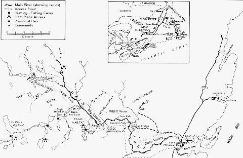
Divided into five distinct sections - Four Ponds Lake, Upper River, Big Steady, Rapid River and
Deep Valley - the relatively short, 57 km Main contains such a diversity of wilderness and
canoeing challenges that it is comparable to much longer wild rivers in other regions of Canada.
The community of Sop's Arm is at the mouth of the Main River. It is one of the many coastal
outports that reflects Newfoundland's maritime heritage with at least 250 years of European
settlement, as well as earlier Norse settlement. Indications can be found at the headwaters that
the Island's native peoples may have travelled between the west coast and White Bay via the
Main River.
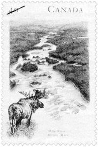
These unique natural features led the Main to be depicted on one of five stamps in Canada Post's
1991 Canada's River Heritage series. Canada Post subsequently chose the Main River stamp as a
representative image of Canada for the November 1991 Phila-Nippon International Postal
Conference in Tokyo. It is also depicted in the Our World: Images of Nature postal collection
produced by Australia Post and in the 1991 Souvenir Collection of the Postage Stamps of
Canada.
Since 1986, the Government of Newfoundland and Labrador has been committed to preserving
and promoting the Main River as a significant natural resource. Most of the river's watershed, its
adjoining streams, and lands near the Big Steady are Crown Land, much of which was protected
from development by Cabinet Order, following a boundary negotiated by the Kruger Paper
Company, Newfoundland Provincial Parks, and Newfoundland's Wilderness and Ecological
Reserves Advisory Council. The province is working earnestly with area interest groups,
including the paper companies, to ensure that the maximum level of aesthetic and physical
protection of the waterway is afforded.
Following completion of a river management plan in 1997, the Main will be formally designated
a Canadian Heritage River.
GEOGRAPHY
Flowing unmodified and unobstructed from its headwaters in the heart of the Long Range
Mountains on the Great Northern Peninsula, the Main River courses southeast from tundra-like
barrens, through expanses of softwood forests and a unique area of grassland, leading to a
spectacular 8-km canyon, and on to the Atlantic Ocean where it empties into White Bay at Sop's
Arm. The nominated river and its corridor encompass a land and water area of approximately
105 km2.
At it's source, the terrain of the Main River combines U-shaped valleys with rounded hills,
characteristic of the 600 million year old geologic processes that formed the bedrock and
surficial geology of Newfoundland. Numerous headwater ponds, near Gros Morne National
Park, lie at the edge of a drainage divide separating the Main River watershed from the Parsons
Pond system which empties into the Gulf of St. Lawrence.
Flowing from an elevation of 370 m at a relatively high gradient averaging 6.5 m/km, the river is
joined by numerous tributaries in the upper reaches. As it moves downstream, the Main
gradually increases in volume and steepness, through narrow, swift channels which alternate
with long steady reaches. Turbulence is present throughout the river as a result of abrupt and
significant changes in gradient, channel width and direction, all causing challenging water
conditions. Fast water mixed with rock gardens, including large boulders, make portages and
lining necessary to successfully navigate the river.
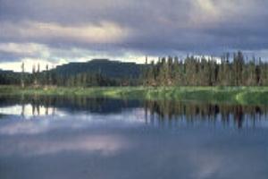
Big Steady on the Main River.
NATURAL HERITAGE
The Main River is one of the last wild and scenic areas of insular Newfoundland. It provides
critical habitat for a variety of wildlife and vegetation in an area of superb natural beauty.
Vegetation in the headwaters is characterized by exposed, scrubby, dwarf-shrub barrens with
pockets of poor growth forest. Farther down the Main, the forests are predominantly balsam fir
and black spruce. Peatland and woodland wildflowers thrive, with species such as laurels,
orchids, cranberry, and the provincial flower, the Pitcher Plant, growing in the upper sections of
the river. Lilies, bunchberry, wintergreen, lichens, and mosses grow in the shady, moist,
woodland areas. The rare, open meadow land of Big Steady, with its calm waters and lush
vegetation, includes several plant species near their northern and southern limits.
The watershed also supports large mammals such as moose, caribou, and black bear. In the
spring, summer, and early fall, moose gather to the river valley at Big Steady. The pine marten,
indigenous to the Island and classified in 1986 as threatened, has been re-introduced to the area.
The river and its many tributaries also support populations of river otter, beaver, snowshoe hare,
mink, red squirrel, lynx, and red fox. About 90 species of bird life frequent the Main River
watershed. Loon, bald eagle, osprey, and the great horned owl are the largest avifauna inhabiting
the area. Close to 100 pairs of Canada Geese make their home in the 200 hectare floodplain of
Big Steady. This prime duck habitat is home to waterfowl including common goldeneye, black
duck, greenwinged teal, and red breasted merganser. The river also contains one of the healthiest
populations of Atlantic salmon in the province, with the gravel-cobble river bed and serene
upper ponds conducive to salmon spawning.
The Main River offers visitors a view of wilderness landscapes unchanged in several millennia.
West-coast inlets, the coastal plain and broad views of the entire Main River watershed can be
seen from the Long Range Mountains. The ancient bedrock, carved 12,000 years ago by the last
glaciers, can be seen along the length of the river. On the Big Steady, ancient birches and spruce
as large as 75 cm at the trunk stand guard by the still waters. In the Rapid River section. the
rapids have cut deeply through bedrock, exposing interesting geological features. At the mouth
of the Main, the traveller can explore the scenic coves, abandoned settlements, and the rugged
coastal hills and bluffs of Sop's Arm and southern White Bay.
HISTORY
As early as 5,000 years ago, Maritime Archaic Indians settled on the Island of Newfoundland.
Archaeological sites near the mouth of the Main River indicate settlements that utilized the
abundant wildlife of the area including harp seals on the ice in White Bay, spawning salmon and
migrating caribou. Evidence of early Inuit habitation dating to about 2 100 years ago has also
been found near the river. Several sites along the west coast of the Great Northern Peninsula,
have produced 900 year old artifacts from the Dorset Eskimo culture, and are within a short
distance of the Main River Watershed. A site along the north side of the river just west of Sop's
Arm, known as the Deer Pits, has been attributed to the nomadic Beothuck culture and was
located in the path of migrating caribou. Researchers believe natives used the Main River as a
travel route. There is little tangible archaeological evidence, however, due to disturbance of the
sites over time.
As early as 1750, French and English settlers shared the abundant fishery of the northeast coast
but, according to an area resident, cannon balls and other artifacts found in household gardens
suggests a violent aspect of some of their disagreements.
Although little material has been published on the early history of the area, D.W. Prowse in
1895, described the relationships between the 18th century French and English settlers in his
History of Newfoundland from the English, Colonial and Foreign Records. Local residents
can also be a valuable source of information on early European settlement in the Sop's Arm area.
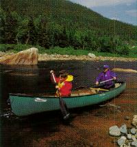
RECREATION
The Main River is recognized as an excellent wilderness river by recreational canoeists and has
attracted outdoor enthusiasts who enjoy kayaking and rafting. With a large number of tributaries,
the Main River offers additional recreational opportunities such as fishing, hunting, nature
observation swimming, and a variety of winter activities.
Fishing: Atlantic salmon and trout are the focus of anglers on the Main River. The Main,
however, is a scheduled river under the Federal Department of Fisheries and Oceans regulations,
which permit only fly-fishing from July to August during the inland salmon run. Fishing licenses
are required. For brook trout, the season runs from mid-January to mid-September. Access for
fishing, other than by air to the headwaters, is via a woods road as far as the bridge crossing.
Beyond the bridge, visitors must travel by foot.
Hunting: Hunters in the area most often pursue big game such as moose, caribou, and black bear
during the 3-month, September through November season. Snowshoe hare, duck, geese, and
snipe may also be hunted. Hunting liciences are required.
Canoeing: The short length of the Main River offers outstanding canoeing opportunities to
challenge the most skilled white-water enthusiasts, while not committing the canoeist to a
several-week journey as is commonly required of many wilderness canoe experiences in
northern Canada. In ideal water and weather conditions, the trip can be completed in 3 - 4 days.
Canoeists choosing to travel the entire river, or the upper section to the woods road bridge
downstream, will have to access the headwaters by aircraft.
Choosing the lower section, from the bridge to the mouth, presents difficult canoeing. The
canoeing season extends from May through September. Several regional outfitters provide
supplies and fly-in and guide services for the Main River corridor.
Camping and Hiking: From mid-June to early September, the campground at Sop's Arm
Provincial Park is open, with 25 sites for tents and trailers, 25 picnic sites, and access to the
mouth of the river.
There are no developed sites along the river itself. Primitive campsites are abundant,
well-distributed, accessible, and easily visible. Many offer protection from wind, if desired, or
exposed places to catch the wind to reduce the nuisance of flies and mosquitoes. Most primitive
sites are level and dry, firewood is plentiful, and bathing is convenient. With little human
disturbance along the river, the water quality is consistently good and suitable for drinking. For
hiking enthusiasts, there are trails along the banks of the river and anglers' trails around some of
the upper ponds, but they are not marked and are of varying quality. You can also hike into the
Big Steady from the bridge on the woods road.
Kayaking/White-water Rafting: The river, with many large boulders and protruding rocks, is
suited to the superior maneuverability of a kayak for safely running the white water. For rafting
enthusiasts, the river presents ideal conditions in May and June when the daily water discharge
ranges from 75 to 100 cubic metres per second. During 1991, the first commercial rafting trip on
the Main River thrilled 36 participants over 23 km of white water.

Rapids on the Main River
Winter Recreational Activities: Snowshoeing and cross-country skiing, which provide
photographic opportunities, are possible on the unmarked trails of the Main River. Ice fishing,
winter camping, and cross-country exploration are other popular options.
VISITOR INFORMATION
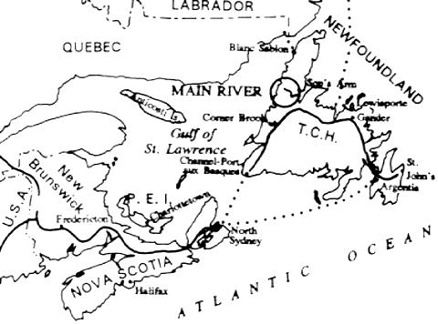
Access: The Main is accessible by using national and regional airlines which offer several daily
flights from St. John's and other Atlantic cities to Deer Lake, just 85 km south of the river. Deer
Lake can also be reached in 5-6 hours from the Island's main ferry terminal at Port aux Basques.
Visitors can then reach the headwater ponds of the Main River in about 45 minutes by arranging
a helicopter or float plane, in advance. A paved road takes visitors to Sop's arm, at the mouth of
the river, in 5-6 hours from the ferry terminal, or 8 hours from St. John's. The lower portion of
the river is accessible by a woods road, from the bridge just below Big Steady.
Accommodation and Services: You can organize your trip in advance by contacting guide and
rental services in St. John's or Corner Brook. Deer Lake (pop. 4233) offers most services
required, including access and guides, and the local settlements of Sop's Arm (pop.445),
Jackson's Arm (pop.652) and Pollard's Point (pop.557) near the mouth of the river are all road
accessible, provide groceries and some supplies, and are developing a more-complete supply and
service capability.
In addition to developed campgrounds at Sop's Arm and Gros Morne National Park, popular
hunting, fishing and outfitting camps are located in the river's headwater lakes: one on Four
Ponds, one on the Main itself, three on the St. Paul's Branch pond system, and one on Caribou
Lake, south of Big Steady. All are reached by float plane. Together, they cater to more than 100
anglers annually, as well as big-game hunters.
Topographic Maps: The Main River is covered by National Topographic Series maps at
1:250,000 by Map 12H (Sandy Lk), and at 1:50,000 by maps 12H/14E & W (Main R.), 12H/11E
(Silver Mtn: White Bay) and 12H/15W (Jackson's Arm: White Bay).
FURTHER INFORMATION
Services, Permits and Regulations: Newfoundland Provincial Parks, Department of Tourism
and Culture, P.O. Box 8700, St. John's, NF, A1B 4J6.
Tourism Information - Accommodation, Air Charters, Guides and Outfitters: Department of
Tourism and Culture, Tourism Branch, P.O. Box 8730, St. John's, NF, A1B 4K2. Tel.: (709)
729-2830 or toll free: 1-800-563-6353; Deer Lake Chamber of Commerce.
Canadian Heritage Rivers System: Member for Newfoundland and Labrador, c/o Director,
Parks Division, P.O. Box 8700, West Block, 2nd Floor, St. John's, NF, A1B 4J6; or, Secretary,
Canadian Heritage Rivers Board, Ottawa, ON, K1A 0H3
Additional Reading:
- Nicol, Keith. "Canoeing Newfoundland's Premier Wild River". Kanawa. Cdn. Rec. Canoeing
Assoc. 1988.
- Goudie. R. Ian. "Big Steady Main River: An area of Ecological Significance and Superb Natural
BeautyĒ. St. John's Evening Telegram. Nov. 27, 1982.
- Nickels, Nick. Canoe Canada. Van Nostrand-Reinhold Toronto. 1976.
- Smallwood, Joseph R. The Book of` Newfoundland. Nfld. Book Publishers, St. John's Nfld.
reprinted 1979.
- Smallwood, Joseph R., ed. The Encyclopedia of` Newfoundland and Labrador. Nfld. Book
Publishers, St. John's, 1981.
- Voyages: Canada's Heritage Rivers - Lynn E. Noel, editor. Published by Breakwater Books of Newfoundland and sponsored by QLF/Atlantic Centre for the Environment. Newfoundland orders
toll free: l-800-563-3333, Canadian orders and inquiries outside Newfoundland toll free: 1-800-387-0172, U.S. orders and inquiries toll free: 1-800-805-1083. Discount available from Canadian River Management Society, Tel. 819-994-3011.

Written and edited by: Michael E. Greco
Photos Courtesy of Canadian Recreational Canoeing Association and Newoundland Parks Division.
Maps Created by: Diamentino Batista
Last Revised:1991