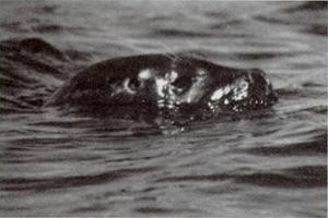
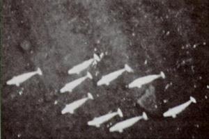
The Seal River gets its name from the 'marine' harbour seals which can be seen in freshwater as far inland as Shethanei Lake
Of the four major rivers in northern Manitoba, the Seal River alone remains completely
undeveloped, wild and rugged. In contrast to the impoundments on the Churchill and the Nelson,
and the rich fur trade and exploration history of the Hayes, the Seal River shows virtually no
evidence of modern human activity. Although in the days before written history the river flowed
through a major native hunting and fishing ground, the Seal now attracts only a few native
people and small groups of hardy wilderness adventurers.
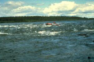
For these groups, travel downriver may require two to four weeks of difficult yet exhilarating
boating. First, an extensive cold-water lake is encountered where winds can create dangerous
waves; then, numerous long rapids in a totally isolated, sub-arctic environment test their survival
skills; finally, travellers must navigate a boulder-strewn tidal estuary.
The Province of Manitoba nominated the Seal to the Canadian Heritage Rivers System in June,
1987. The nominated section is 260 km long and extends from the junction of the North and
South Seal rivers, at Shethanei Lake, to Hudson Bay.
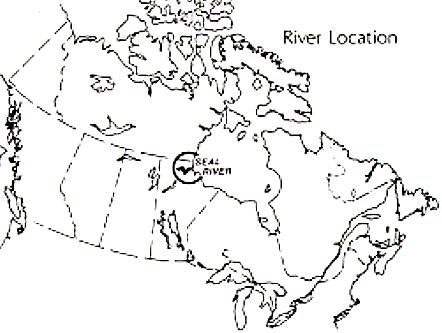
The Seal River is located in the roadless wilderness of northern Manitoba, 1000 km by air
charter from Winnipeg. The Seal estuary is 45 km across Hudson Bay from Churchill. Other
than Churchill (population 1,300), the only settlement in the area is Tadoule (population 250), a
small Chipewyan community located along the South Seal River at Tadoule Lake.
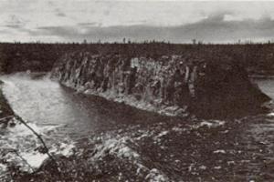
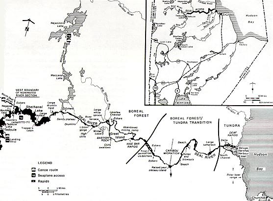
The Seal begins its course at Shethanei Lake, ringed by the magnificent sand-crowned eskers
that are so much a part of the Seal River landscape. Then, passing stands of black spruce, its
velocity increases toward the Big Spruce River Delta, and accelerates dramatically into the
rapids and gorges which surround Great Island. Beyond the island, the river leaves the boreal
forest and enters a sparsely-treed, transitional subarctic environment of tundra and heath,
christened by the natives the "Land of Little Sticks". Finally, the Seal flows through barren arctic
tundra, huge boulder fields and complex rapids, spilling into a beautiful estuary where its
freshwaters mix with the salt of Hudson Bay.
Except for the less than two dozen skilled rafting and canoeing parties which visit the river each
year, and the occasional native fisherman and trapper, there is virtually no human activity along
the Seal River. The remote, roadless nature of this region has meant that activities such as
mining exploration have been costly, air-supported ventures, and even the discussion stages of
any development of the area's hydro potential are many years away.
The Seal River area played an important role in native hunting, fishing and travelling. The white
man found the area less hospitable. Isolated and difficult to navigate, with infertile soils and a
cold climate, the Seal was quickly ruled out as a travel, trade or settlement corridor.
The river's nomination to the CHRS was not based primarily on its human heritage, but there are
several historical features of interest:
The river's nomination to the CHRS was based in part on its ability to provide an outstanding
whitewater wilderness river trip. A trip from Tadoule to Hudson Bay would encounter, in order:
20 km of lake travel, with three major sets of rapids and a boulder field between Tadoule and
Shethanei Lake; 40 km of open, shallow water on Shethanei Lake, where dangerous waves and
heavy winds can make travel impossible for days; 64 km of variable channels through numerous
choppy rapids and a narrow, deep gorge; 28 km of intermittent whitewater along the scenic
channel of Great Island including a possible 3 km portage; 124 km of flat country, transitional
subarctic tundra forest and boulder field rapids; 4 km through the estuary's maze of marshes,
tidal flats, islands, shelves and reefs passable only on the north channel and then only when
properly timed with the tides; and, finally a rendez-vous with a float plane or water taxi from
Churchill on the Hudson Bay shoreline.
In addition to a rugged wilderness river trip, the Seal River offers other recreational
opportunities:
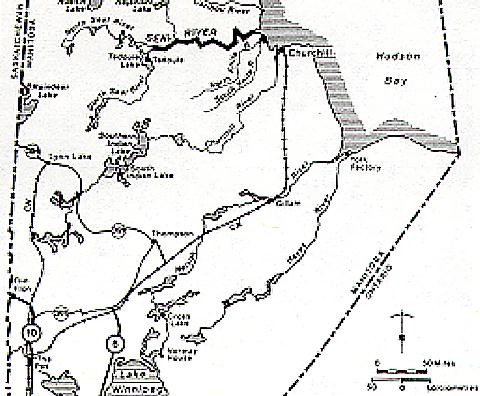
Access: The closest permanent road passes 275 km southwest of the Seal. One can fly from Flin
Flon, Lynn Lake, Thompson, or Churchill to Tadoule, Shethanei Lake or to the east or west ends
of Great Island. Access from southern Canada to Churchill is possible by daily air service or
three times weekly rail service from Winnipeg and The Pas. For those wishing to extend their
trip by 200 km or more, it is possible to start further upstream landing by float plane on any of
the numerous lakes along the North and South Seal rivers or in the Nueltin Lake system, or by
beginning one's journey from road accessible Southern Indian Lake.
Egress is also difficult. While motorised rafters may be able to travel the 45 km over the
treacherous shoals and open water of Hudson Bay to Churchill, canoeists and kayakers cannot do
so safely. All river travellers are advised to arrange for water taxi or aircraft pick-up from the
Seal River estuary.
Accommodation and Services: There are no accommodation or visitor services along the Seal.
Tadoule has a landing strip, nursing station and grocery store but no other services. Churchill
and Thompson are the primary service centres with support facilities and accommodation.
Outfitters and guides may also be arranged from Flin Flon, Lynn Lake, The Pas, and Winnipeg.
A further alternative is to arrange trips through wilderness camps at Nueltin Lake or the South
Knife River.
Travellers are strongly advised to make detailed plans for a trip. Hazards here are plentiful. The
river is fast, shallow and ice-cold. Capsizing and hypothermia are very real possibilities. Rapids
are often long, shallow and boulder-strewn. Navigation for motorised craft may not be possible
in years of low precipitation and portage paths do not exist at present. Travel on the estuary and
Hudson Bay requires prior knowledge of tide charts and healthy respect for unpredictable
weather, ice, and polar bears.
Topographic Maps: Maps for the Seal River are available from the Canada Map Office, 615
Booth Street, Ottawa, Ontario K1A 0E9: 1,250,000 scale 54L, 54M, 64I and 64J; 1:50,000 scale:
54L 13, 14 and 15; 54M 2, 3 and 4; 64I 13, 14,15 and 16; and 64J 9, 10 and 16. Maps at a scale
of 1" = 4 mi. are available for all Manitoba canoe routes from: Department of Natural
Resources, Surveys and Mapping Branch, 1007 Century Street, Winnipeg, Manitoba R3H 0W4.
Seal River - Services, Permits and Regulations: Manitoba Department of Natural Resources,
Parks Branch, 4th Floor, 258 Portage Ave., Winnipeg, Manitoba, R3C 0B6.
Tourist Information - Manitoba Canoe Routes, Outfitters, Guides, Accommodation and
Visitor Services: Travel Manitoba, 155 Carlton St., Winnipeg, Manitoba, R3C 3H8.
Canadian Heritage Rivers System: The Secretary, Canadian Heritage Rivers Board, Ottawa, Ontario, K1A 0H3; or the Member for Manitoba, Canadian Heritage
Rivers Board, c/o Assistant Deputy Minister, Manitoba Department of Natural Resources, Box
50, Room 800 1495 St. James Street, Winnipeg, Manitoba, R3H 0W9.
Additional Reading:
| More Information | Return to CHRS homepage | Table of Contents |
|---|