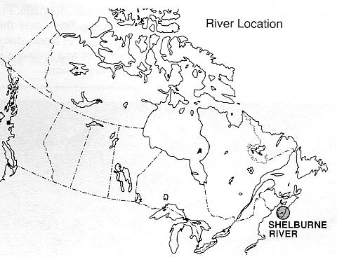
THE SHELBURNE RIVER SYSTEM
NOVA SCOTIA
The Shelburne is the most remote wilderness river in Nova Scotia. Along its course, it takes the traveller from wilderness barrens to the edge of civilization. Although Nova Scotia has the longest history of European colonization and continuous settlement in Canada, the low productivity of the barrenlands has prevented development from encroaching significantly on the river. The Shelburne begins in the heart of the western Nova Scotia Granite Barrens and flows through a landscape with only minor rises and depressions. While some parts of the river corridor support stands of large timber, the surrounding barrenlands consist of low heath vegetation, bogs, and patchy forest stands. As the river continues toward Lake Rossignol, forest stands are
large enough to attract commercial interest. Here you contact roads and
simple bridges of the forest industry.
The Shelburne River formed an important part of the spider web of
rivers and lakes which allowed the Micmac (Mi'kmaq) Indians to travel
freely throughout the region. The canoe has always been, and remains,
the most popular and practical method of transportation.
Although the barrenlands are unproductive for vegetation, the conspicuous eskers and intermixed large wetlands combine to create a river of
exceptional natural beauty. About 75% of the river's watershed is Provincial Crown Land in a wilderness condition. The major private landowner
in the area is the Bowater Mersey Paper Company Limited. The company has undertaken management practices to protect the river corridor where
it lies within its holdings.
In recognition of its outstanding natural landscapes and the wilderness
recreation it affords, in 1993 the entire Shelburne River was nominated
to the Canadian Heritage Rivers System.
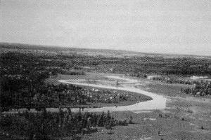
Shelburne River, Nova Scotia
GEOGRAPHY
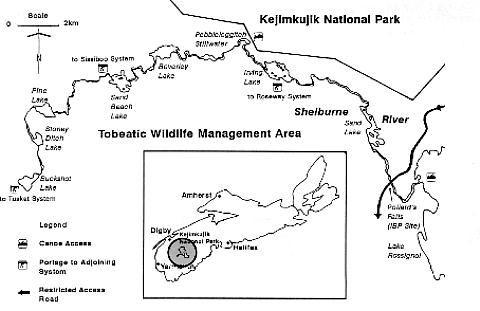
A tributary of the Mersey River, the Shelburne River flows 53 km through the heart of the western interior of Nova Scotia. From its source at
Buckshot Lake, the river flows in an arc north, east, and then south to Lake Rossignol. It has a watershed of 27,739 ha and flows through two
distinct geographic regions: across the Granite Barrens from the headwaters to Irving Lake (upper 2/3 of the river), and over the slightly more
productive Quartzite Plains from Irving Lake to Lake Rossignol.
In part, the barrens exist because repeated advances of glaciers scraped the rock bare. Much of the area has also been impoverished by repeated fires.
These were often set deliberately dozens of kilometres away at the seacoast and allowed to burn inland, uncontrolled, in order to clear land for
pioneer pastures.
As a result of erosion-resistant underlying bedrock along its course and low gradients, the river flows only slowly over the surface for much of its
length. It first fills a shallow depression to form a lake, then overflows, following a shallow dip in the land's surface to the next depression, and so
on. In this low-relief landscape, moving waters comprise slightly less than half the river's length; calmer stillwaters another third. The remainder is
occupied by eight shallow, rocky lakes spaced along its course. Where the river cuts across bands of harder rocks, rapids and low waterfalls have
been formed.
NATURAL HERITAGE
Geology: The dominant landscape features of the Shelburne have resulted from exposed underlying bedrock and glacial action. A large portion
of southwestern Nova Scotia is underlain by a mass of granite formed about 400 million years ago by the melting of the surrounding rocks deep
below the earth's surface. The molten rock rose to the surface and solidified. As a result of its resistance to erosion, this granite mass still bulges
above the surrounding metamorphic rocks, forming the low rise of South Mountain. For the upper two-thirds of its length, the Shelburne flows
over this granite, which is covered thinly, if at all, by a layer of loose, stony, granite till. The surface is strewn with boulders and drainage is
poor, with peat bogs forming in the shallow depressions.
The lower portion of the river, east of Irving Lake, flows over somewhat more easily eroded rocks. including quartzites and slates. These
metamorphic rocks were formed about 540 million years ago and are the rocks from which the younger granite was created. Deeper tills create
a landscape more dominated by forests as the river approaches Sand Lake. From Sand Lake east to a large stillwater near the river's mouth, the
Shelburne flows over still softer slates and siltstones formed about 500 million years ago. Again, tills are slightly more developed here, giving
rise to more productive forests. Outstanding examples of undisturbed glacial features are associated with the Shelburne River. Large erratics
line the river and lakes from the headwaters to Irving Lake. Outstanding examples of eskers wind from Pine Lake to Sand Beach Lake and
outwash plains occur along 2 km of the river between Sand Beach and Beverley lakes.
Vegetation: The Shelburne River corridor presents a fascinating contrast in vegetation. Not only does it contain some of the most barren land in the region, but it also supports some of its most significant old forest stands. On the Granite Barrens, only the shallow valleys of the river and its tributaries support a "linear forest" of red maple, some ash. and wire birch. Heath plants and patches of low scrubby forest form the dominant vegetation of the gentle rises of the surrounding barrenlands. Pure stands of large, old white pine occur in the area surrounding Pine Lake, sporadically along the river to Granite Lake, and again south and west of Irving Lake. These are remnants of the great pine forests which were harvested to feed the shipbuilding and lumber industries of the province in the 1800's. A number of high quality, old-growth hemlock stands with trees over a metre in diameter border the river east of Irving Lake. One stand between Sand Lake and Lake Rossignol contains trees up to 125 cm (50 in) in diamter, and has been identified as the "Shelburne River" IBP (International Biological
Program) site.
Wildlife: The large area of semi-barren wetlands and pine forests associated with the Shelburne River, west of Irving Lake, is important wildlife
habitat. The area supports a large black bear population and the largest moose population on mainland Nova Scotia. As part of a larger wilderness
area, the Shelburne River provides high quality wildlife habitat and refuge for species which prefer large remote areas. Many birds which visit or
breed in Nova Scotia require the mixture of interior unfragmented habitats that this wild area provides. As well, the many wetland types provide
considerable habitat for nesting ducks, and populations of beaver, otter and muskrat.
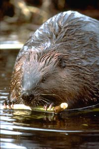
Beaver
HISTORY
It is likely that the first human inhabitants arrived in this area shortly after the last glaciers retreated. Stone artifacts found along the Shelburne - arrowheads, knives, scrapers...- may be more than 5000 years old. Mi'kmaq Indians were travelling the river by canoe when the first contacts were made with Europeans 400 years ago. Until the present century, they used the Shelburne for fishing and as a key transportation route
linking the interior to the coast by the Sissiboo, Tusket, Roseway and Mersey river systems. According to legend, Jim Charles, a local Mi'kmaq guide, travelled the Shelburne to visit a secret gold mine beyond its headwaters, and, after killing a man in a dispute, hid for more than a year in a shallow cave under a rock near Sand Beach Lake.
The European settlers who colonized the coastal regions of the province followed the Mi'kmaq canoe routes along the rivers to hunt, fish, trap
and explore. As the inland areas of the province became sparsely settled in the 1800's, the canoe became an important vehicle for woods travel,
and continued so for recreational purposes. Beginning in the 19th century, loggers followed the rivers upstream, cutting along their banks and
"driving" the logs downstream to the mills. Both large logs and four foot lengths of pulpwood were driven on the Shelburne River, and, in the
late 1800's and early 1900's, temporary dams were built on some of the lakes to "save" water for driving in the spring.
Although the Mi'kmaqs travelled less as the province became colonized by Europeans, many Mi'kmaqs, as well as local settlers from the nearby
communities, relied on guiding fishermen, hunters, and sightseers through the area to supplement their incomes until after World War II. Canoeing
the Shelburne as part of a loop trip, which included waterways that are now part of Kejimkujik National Park, was first popularized in the 1908
book, The Tent Dwellers, by Albert Bigelow Paine. Canoeists still come to the area to travel the route he described.
The Mersey Paper Company (later Bowater Mersey) purchased large blocks of land along the Shelburne River and began cutting in the area in
1928. Approximately one-third of the land adjoining the river is now owned by Bowater Mersey.
In 1968, the Government of Canada established Kejimkujik
National Park adjacent to the Shelburne River, with 5% of the
river's watershed lying within the park.
RECREATIONAL USE
Wilderness Canoeing, Sightseeing, and Nature Appreciation:
The whole of the river corridor provides outstanding
wilderness canoeing opportunities. The upper region from the
headwaters to Irving Lake provides a superb wilderness
landscape with no settlements. A few forest roads, bridges,
forestry operations, and company or government owned cabins
are rare intrusions on the otherwise completely undisturbed
riverbank. Despite the low relief associated with the river,
the undisturbed barrens, bogs and forests along the Shelburne
create dramatic, wild landscapes. The eskers between Pine
Lake and Sand Beach Lake provide scenic viewpoints with
panoramas of the surrounding forest and barrens. White water
canoeing (when the river is high), quiet paddling on long
still waters, and lake hopping are all possible on different
stretches of the river. From the height of land on which the
Shelburne rises, rivers flow to the nearby surrounding ocean
like the spokes of a wheel radiating from a hub. For extended
trips, canoeists can connect with four other rivers from the
Shelburne: the Tusket, Sissiboo, Roseway and the upper
Mersey.
It is possible to canoe on the Shelburne from ice-out
(usually late April) until freeze-up (November) but it is
mostly fed, like many of the other streams in the region, by run-off. This leads to
a large drop in water levels of over 50 cm during July and
August, requiring excessive portaging. Commonly, flows do not
increase significantly until mid-October and after this time
there is a good chance of better water levels for canoeing.
The high wind exposure on the larger lakes caused by the
elevated, relatively flat terrain, can challenge experienced
canoeists, as can the white water stretches. Intermediate
white water skills are recommended, as is competence in
wilderness travel.
Kejimkujik National Park: One of the park's canoe routes on
the upper Mersey system leads to Pebbleloggitch Lake, which
is linked to the Shelburne between Granite and Irving lakes
by Pebbleloggitch Stillwater. A loop trip of about one week
is possible by following the "Tent Dwellers Route" on the
Shelburne from Pebbleloggitch Stillwater down to Lake
Rossignol, and then paddling up the Mersey to the National
Park and continuing to Pebbleloggitch Lake. A complete
wilderness trip is available by paddling upstream from
Pebbleloggitch Stillwater to Buckshot Lake, through the
barrens. Other access points to the river require challenging
portages from the Sissiboo, Tusket, or Roseway systems or a
paddle upstream from the mouth of the river at Lake
Rossignol. It is estimated that about 150 people canoe
portions of the river each year, usually in parties of 2 to 4
people.
Angling: Native trout stocks in the river sometimes provide
good sport fishing, but the low overall productivity of the
watershed means that populations are limited.
VISITOR INFORMATION
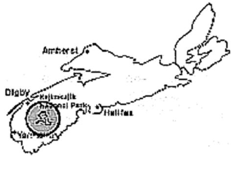
Access: The Shelburne River is inaccessible by public road.
Forest management roads cross the river, but are gated. The
most practical access to the Shelburne is via canoe from
Kejimkujik National Park or from Lake Rossignol, both of
which are about a three-hour drive (160 km) from Halifax via
Highway 103 and Route #8 (the Kejimkujik Drive).
Accommodation and Services: No accommodations or services are
available along the river, but campgrounds and information
services are available at Kejimkujik National Park. General
services including simple accommodation and supplies, are
found in the nearby communities of Caledonia and Maitland
Bridge.
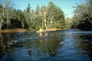
Canoeing on the Shelburne, Nova Scotia's last wilderness river
Canoeing is the only practical means of traveling the river.
For most of the summer, however, water levels in fast-flowing
stretches may be too low for paddling, and portages currently
are poorly marked and may be impossible to find. Prepared
information on canoeing the river is sparse.
Maps: National Topographic Series Maps available for the
Shelburne River include 1:50,000 series: 21 A/3, 21 A/4, 21
A/5, and 21 A/6. However, the 1 ;250,000 series map, 21 A
(Annapolis) is sufficient. Maps are available from the Canada
Map Office, 615 Booth Street, Ottawa, Ontario K1A 0E9.
Canoeing information on the Shelburne below Sand Lake is
available on the Canoe Waterways Map "Lake Rossignol", 1":
1320' from the Nova Scotia Government Bookstore, Box 637,
Halifax, Nova Scotia, B3J 2T3. Kejimkujik National Park, Box
236, Maitland Bridge, Nova Scotia publishes a backcountry
guide and topographic map with canoeing/hiking information on
the canoe routes and trails in the park which provide access
to the Shelburne.
FURTHER INFORMATION
Permits: A permit is necessary in order to travel in the
Tobeatic Wildlife Management Area. The Shelburne River flows
along the boundary of the Management Area from its headwaters
to just above its mouth at Lake Rossignol. A Management Area
Permit is required for anyone travelling the river. Permits
are available from the Nova Scotia Department of Natural
Resources, 552 Main Street, Milton, Nova Scotia. There is no
charge for permits but application must be made in person.
Office hours are 8:30-4:30, Monday to Friday.
Registration for travel in the backcountry of Kejimkujik
National Park is also mandatory. Office hours are the same,
but include evenings and weekends in summer. Information on
camping and travel in the National Park is available from the
park address given above.
Tourist Information: Information on canoe rentals, outfitters
and guides is available from the Nova Scotia Adventure
Tourism Association, 61 Bonnie Brae Drive, Dartmouth, Nova
Scotia B2W 1E3. Canoeing information is also available from
Canoe Nova Scotia, 5516 Spring Garden Road, Box 3010, South
Halifax, Nova Scotia B3J 3G6.
Lodging, Accommodation and Visitor Services: Nova Scotia
Department of Tourism and Culture, Box 456, Halifax, Nova
Scotia B3J 2R5. Phone toll free: 1-800-565-0000 (Canada) or
l-800-565-6096 (USA).
Canadian Heritage Rivers System: In Nova Scotia contact:
Parks & Recreation Division, N.S. Dept. of Natural Resources,
RR 1, Belmont, Nova Scotia B0M IC0. Tel.: 1-902-662-3030;
National contact: National Manager, Canadian Heritage Rivers
Secretariat, Ottawa, Ontario K1A 0M5. Tel.: 1-819-994-2913.
ADDITIONAL READING
Parks Canada. Backcountry Guide: Kejimkujik, Maitland
Bridge, N.S. ca.1990.
Davis, D. S. 1987. Natural History Map of Nova Scotia. Nova
Scotia Museum, Halifax, N.S.
Dill, Charles, ed. 1983. Canoe Routes of Nova Scotia. Canoe
Nova Scotia & N. S. Camping Assoc., Halifax.
Leefe, J. Momson, M. Evans, E. Mullen. '91. Kejimkujik
National Park: A Guide. Four East Publ., Halifax,
Mullen, E. & M. Evans, 1989. In the Mersey Woods. Bowater
Mersey Paper Company, Liverpool, N.S.
Leefe, J. G. 1995. "In the Land of the Tent Dwellers": In
Voyages: Canada's Heritage Rivers. Noel, Lynn E., Breakwater Books, St.John's, Nfld.
Payne, A. 1908 (reprint 1993). The Tent Dwellers. Nimbus Books,
Halifax, Nova Scotia.
Raddall, T. H. 1988. "The Lost Gold at Kejimkujik". In
Footsteps on Old Floors, Pottersfield Press, Porters Lake,
Nova Scotia.
Written by: Eric Mullen
Edited by: M. Greco
Photos Courtesy of Parks Canada
Maps Created by: M. Robitaille
Last Revised:1994