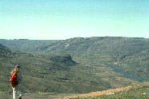
Soper River valley near Mt. Moore (Baffin Island)
Like a long green ribbon on a coarse brown backdrop, the Soper River (locally known as the Kuujuaq) winds its way from the highlands of the Meta Incognita Peninsula to Soper Lake and the salt waters of Pleasant Inlet along the south coast of Baffin Island. For centuries, this relatively verdant valley served the needs of the coastal Inuit both as a source of game and berries and as a short and direct travel route to other parts of the island. Today the valley is no less important as it continues to be a focus of local activity.
Willow growth in the valley illustrates the richness generated by the micro climate. Many sites are heavily vegetated with the unique occurrence of trees reaching 3.6 m in height. A profusion of flowers adorns the valley bottom and longer slopes in the early summer, and arctic hare, wolf, fox and caribou are plentiful.
By arctic standards, the Soper River produces a major flow of water, being navigable for about 50 km inland. Helping maintain this level of flow, the Livingstone River and the Joy River drain significant areas to the north and west. All together the drainage basin covers an area of over 2,500 sq. km.
With its richness of natural and human heritage, the Soper River valley provides exceptional opportunities for visitors to understand and appreciate these Canadian Heritage River qualities. Like earlier generations of people, travelling by land, on the water and over the snow, today's visitors find the
Soper valley a very accessible and enjoyable area to visit.
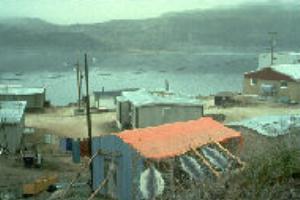
Bordering the area's southern boundary is the Inuit community of Lake Harbour on adjacent Glasgow Inlet. It is the closest community to Iqaluit - the administrative and transportation centre of the Baffin Region. Iqaluit itself, is closely linked by daily air service to the major centres of Ottawa and Montreal.
Intensive metamorphism dating back 1,740 million years ego and extensive folding in the largely
granite bedrock created a complex and very interesting geological picture in the Soper River
drainage. Intrusions of crystalline limestones, schists and quartzite add to the scenical appeal and are
especially interesting. Particularly noteworthy is a small deposit of Lapis lazuli (a blue gemstone) in
the longer reaches of the valley - one of the few known occurrences in the world. Mica is also found
in extensive deposits throughout the area.
Extensive glaciation on the highest levels of the peninsula pushed glacial till into longer elevations
leaving largely exposed bedrock. The Soper River originates on this glacially-scoured plateau of low
relief, where shallow basins, almost devoid of vegetation, drain away the summer meltwaters. Small
lakes and creeks combine their flows to form the Soper River and begin to cut increasingly deeper
into the level of the plateau. In the middle reaches of the river, steep valley walls loom over the gently
flowing river below, sometimes narrowing but mostly marking a broad river valley that differs
markedly in character from the uplands above. Major landmarks include Mt. Joy (610 m) and Mt.
Moore (535 m).
Here in the valley, side creeks tumble over the high valley walls and a few major tributaries also
contribute their waters, resulting in low, relatively lush wetlands and a broad meandering river
wending its way through the rich valley. The river bed is punctuated occasionally with bands of
intrusive bedrock that create rapids and pools along its course. Massive river terraces stand as high
as 34 m above the present river level. In the lower reaches of the river, the elevation of the
surrounding uplands diminishes significantly and the relief lessens as the valley broadens even
further before emptying through the Soper River Falls into Soper Lake. Soper Lake is a very special
hydrological feature. Due to the high tides (10.6 m) in Hudson Strait, reversing falls control the outlet
of the lake making the lake a meromictic combination of fresh and salt water.
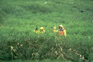
The warm microclimate created in the valley allows a comparative abundance of vegetation. In
contrast to the relatively sterile uplands with their scattered lichens and mosses, low wetlands in the
valley encourage the growth of many sedges, cotton grass, sphagnum moss and yellow mountain
saxifrage. A heath plant community of willow, dwarf birch, arctic heather, Labrador tee and a
multitude of berries commonly grow on much of the valley floor and longer slopes. Unique willow
growth occupies a number of sites in the valley with trees reaching heights of 3.6 m.
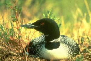
A variety and unusual concentration of wildlife are attracted to the valley. Among the mammals,
caribou, fox, wolf, and hare frequent the area. Lemmings provide an important food source for a
range of predators, especially for rough-legged hawks. Peregrine and gyr falcons nest here along
with upland species such as snowbuntings, horned larks and plovers, and seabirds such as loons,
guillemots, terns and murres.
The river corridor also provides excellent opportunities for guided tours by motorized canoe travel, organized in Lake Harbour, and travelling up river on a day use or overnight basis. Short excursions off the river to points of interest are an appealing component of any trip. Similarly, Soper Lake offers excellent potential for boat tours.
Hiking through the valley and onto the upland area is always a rewarding experience, offering diversity and contrast" in hiking terrain. The unusually lush vegetation, abundant wildlife and attractive waterfalls combine with scenic vistas and wildflowers to make the valley a wonderful place to pursue photography and nature study.
In winter the land takes on a whole new character. Although possible throughout the winter, most activity occurs during the spring when the days are long and the temperatures warmer. Cross-country skiing up the valley offers spectacular scenery with only a low level of difficulty. Both dog team travel and snowmobiling over the cold, clear arctic landscape can be exhilarating activities.
Although the Soper watershed is essentially a linear corridor, many areas hold considerable interest and potential for extended recreational activity. Three significant locations, attractive for their special features and range of activities are: the area around Soper Lake; Livingstone River Falls and vicinity; and, the entire area surrounding Mt. Joy to Cascade Creek.
Access:
Iqaluit, connected to the southern centres of Ottawa and Montreal by daily jet service, is the departure point for trips into the Soper River valley. Three options are posssible. The first begins with a short (half hour) scheduled flight (3 days a week) to Lake Harbour. Once in the community, the Soper is immediately accessible on foot or by boat. Guides are available in the community for boat or snowmobile trips. A second option is to charter an aircraft in Iqaluit to land in the Soper valley. Two designated landing sites have been identified in the middle reaches of the river, convenient for boat
travel downstream to Lake Harbour. A third option is to travel overland along the Itijjajiaq Trail, which leads you to the Soper River and all the way to Lake Harbour. This option requires hiring a guide in Iqaluit to provide transportation across Frobisher Bay by boat to the trailhead.
Accommodation and Services:
Iqaluit is a full service regional centre of over 3,000 people, the hub of all travel in the eastern Arctic. Hotels, restaurants, a variety of retail outlets and specialty shops for local arts, crafts and foods are all available to the visitor. In addition, boat and air charters are provided by local companies, and guides and outfitters.
Lake Harbour is a small community of less than 400 people. Internationally renowned soapstone carvings produced by community people are available for sale at the Kimik Co-op or from the carvers directly. The community has a hotel and cafe as well as two retail outlets for basic food, equipment and supplies. Guides and outfitters are available to take people into the Soper valley or to destinations along the coast. Coastal trips provide new opportunities to view marine
mammals such as seals, whales, and polar bears, and to visit heritage sites.
The maps may be obtained from: Canada Map Office, 615 Booth St., Ottawa, Ont. K1A OE9 (613- 952-7000); or Energy, Mines and Resources,4914-50th Street, Yellowknife, Northwest Territories, X1A 2L9 (403-920-8299).
Services, Permits and Regulations: Economic Development and Tourism, Yellowknife, Northwest Territories (NWT), Canada, X1A 2L9 (403-873-7905); Economic Development and Tourism, Iqaluit, NWT, XOA OH0 (819-979-5081).
Tourist Information - Accommodation, Air Charters, Guides and Outfitters: Economic Development and Tourism, Iqaluit, NWT, XOA OH0 (819-979-5075); Baffin Tourism Association, Box 1450, Iqaluit, NWT XOA OH0 (819-979-6551); Unikkaarvik Regional Visitor Information Centre, Iqaluit, NWT (819- 979-4636); Travel Arctic, Yellowknife, NWT, X1A 2L9 (1-800-661-0788 or 403-873-7200).
Canadian Heritage Rivers System: Member for the Northwest Territories, Canadian Heritage Rivers Board, c/o Dept. of Economic Development and Tourism, Yellowknife, NWT, X1A 2L9; Secretary, Canadian Heritage
Rivers Board, Ottawa, K1A OM5.
Additional Reading:
Blackadar, R.G. 1967. Geological Reconnaissance. Southern Baffin Island. District of Franklin. Geological Survey of Canada Paper 66-47. Ottawa: Department of Energy Mines and Resources.
Kemp, William B. 1984. "Baffinland Eskimo" in Handbook of North American Indians. Smithsonian Institute, Washington. pp. 463-475.
Maxwell, Moreau S. 1985. Prehistory of the Eastern Arctic. New York: Academic Press Inc.
Porsild, A.E. 1964. Illustrated Flora of the Canadian Arctic Archipelago. National Museum of Canada Bulletin No. 146. Ottawa: Queen's Printer. pp. 218.
Soper, J. Dewey. 1936. "The Lake Harbour Region, Baffin Island" in Geographical Review, Vol 26.
Soper, J. Dewey. 1933. "Solitudes of the Arctic" in Canadian Geographical Journal. Vol. 7, No. 3, pp. 102-115.
Soper River Map and Guidebook. 1996. - available from any Nothwest Territories "Tourist Informaton" offices at the addresses above.
Voyages: Canada's Heritage Rivers - Lynn E. Noel, editor. Published by Breakwater Books of Newfoundland and sponsored by QLF/Atlantic Centre for the Environment. Newfoundland orders
toll free: l-800-563-3333, Canadian orders and inquiries outside Newfoundland toll free: 1-800-387-0172, U.S. orders and inquiries toll free: 1-800-805-1083. Discount available from Canadian River Management Society, Tel. 819-994-3011.
| More Information | Return to CHRS homepage | Table of Contents | A Canadian Arctic Adventure |
|---|