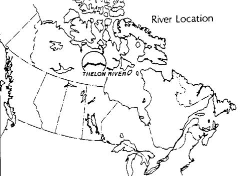
THE THELON RIVER
Northwest Territories
The Thelon is the largest river in the Northwest Territories flowing into Hudson Bay. It winds
through a broad valley, often lined with thick stands of spruce, yet is surrounded by sweeping
barren lands - the treeless tundra of Canada's north. This boreal-Arctic oasis supports a rich and
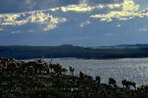
unusually diverse northern concentration of wildlife. The Beverly caribou herd, 300,000 members
strong, crosses the river in large groupings at a number of spots during the herd's annual
migration. Barrenground grizzly, muskox, fox, lynx, wolf, moose, wolverine, peregrine falcon and
more than 10,000 moulting Canada geese are common here, many in the Thelon Game Sanctuary
which surrounds the river's middle reaches to Beverly Lake.
The Thelon, together with its sister river, the Kazan, has long been home to the Caribou Inuit, the
only inland community of Inuit in Canada. Thelon shores, particularly from Beverly Lake on
downstream, are a treasure-house of pre-historic artefacts and Inuit campsites. Some dating back
thousands of years are still in use today.
And the Thelon continues to play a vital role in the lives of the Caribou Inuit. Comprising 1,000
of the total of 20,000 Inuit who live in the region of Nunavut, the Caribou Inuit reside primarily in
the community of Baker Lake at the river's mouth. It was due
Beverly Caribou Herd in post-calving migration
largely to their strong desire and effort to have the river and their traditional life on it commemorated by all of Canada that, in July 1990, the Thelon was designated as a Canadian
Heritage River.
GEOGRAPHY
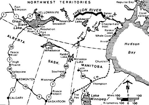
From as far apart as 200 km east of Great Slave Lake and the northern Saskatchewan border,
waters of the Thelon collect to flow for 900 km across the NWT's Mackenzie and Keewatin
districts, then into Baker Lake and Chesterfield Inlet. This 142,400 km2 watershed is the largest
unaltered drainage basin emptying into Hudson Bay.
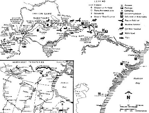
The section designated a Canadian Heritage River includes the river's entire middle and lower
reaches, consisting of the 545 km from Warden's Grove, 50 km from the river's junction with the
Hanbury, to Baker Lake. The 1-2 km wide, meandering, river channel contains considerable fast
water but requires no portages from the Hanbury junction to the lower reaches where the Thelon
widens into three vast lakes: Beverly, Aberdeen and Schultz. From Schultz Lake, the river
narrows and a 100 km stretch of fast water leads to the river's mouth at Baker Lake.
Located at the geographic center of Canada and inaccessible by road. Baker Lake is 900 km by air
east of Yellowknife, and 1500 km by air north of Winnipeg. Nevertheless hotel accommodation,
food, supplies, outfitting and other services are among the best available in the far north, and
Baker Lake offers visitors an unforgettable taste of the modern Caribou Inuit cultural way of life.
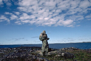
Inukshuk
NATURAL HERITAGE
The pristine wilderness of the Thelon provides abundant and diverse wildlife habitat and many
areas of exceptional natural beauty. Its forest-tundra supports a unique assemblage of boreal and
arctic species and some of Canada's most important northern ecosystems. Among its more
significant features are:
- 330,000 migrating caribou, following the river to calve north of Beverly Lake, sometimes
swimming across in a kilometre-wide band;
- the largest flock in NWT of the large species of Canada geese, between Beverly and
Aberdeen lakes;
- one of few inland colonies of lesser snow geese;
- breeding grounds for the endangered peregrine, gyr-falcon and rough-legged hawk and
habitat for the rare wolverines, and for arctic fox and wolf;
- 75-100 moose and more than 2,000 muskox between Warden's Grove and Lookout Point. (The muskox have thrived under protection of the Thelon Game Sanctuary. At the turn of the century, only a few hundred survived, decimated by the late 19th century European demand for muskox robes);
- important denning grounds for barren-ground grizzly preying on geese and eggs in spring
and summer;
- an uncommon mix of boreal and arctic fish species in Beverly Lake; and,
- impressive scenic features: extensive flats of pure white sand at the Thelon-Hanbury
junction and Lookout Point; l5m high sand embankments fringed by boulder beaches at
Thelon Bluffs, where rapids course through sandstone cliffs; seven terraces 20-l00m
high-old lake and marine beaches, at West Aberdeen; and, the spectacular Aleksektok
Rapids, 70 km from Baker Lake.
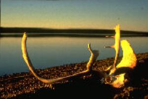
Caribou skull on the Thelon
HISTORY
The Thelon barrenlands, long-time home to the Inuit, have been undisturbed for centuries. A trip
on the river is truly a voyage back in time. Perhaps the most dramatic glimpse of past and present
Inuit culture is an inukshuk-a pile of rocks standing quite visibly as markers on the landscape.
Inukshuk mark almost every vital aspect of Inuit life-land and water routes, caribou migratory
paths and river crossings, fishing spots, campsites, lookouts, and food caches. Archaelogical sites,
structures and artefacts which include tent rings, stone fox traps, kayak stands, graves, hunting
blinds and quartzite flakes used as scrapers, are plentiful but are protected under federal and NWT
laws and must be left undisturbed. Much of the area's prehistory can be learned from these sites,
and, if disturbed, that opportunity may be lost forever. The best sites are at Schultz and Aberdeen
Lakes, Peqetuaq, and Isarurjuaq Peninsula.
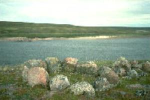
Inuit food cache, one of many archaeological sites, along the Thelon
The journals of northern explorers who travelled the Thelon can add immeasurably to a trip here:
- Samuel Hearne crossed the Thelon on his overland walking from Churchill to the unknown interior, recording it in his 1770-71 Journey from Prince of Wales Fort to the
Northern Ocean.
- In 1893, J.B. Tyrrell, one of the great pioneers of the Geological Survey of Canada,
explored the Thelon and Dubawnt. His brother, J.W., described the journey in Across the Sub-Arctics of Canada
- David Hanbury travelled the Thelon in 1989 and returned 2 years later. The detailed
journal of his explorations entitled Life and Sport in the Northland of Canada is
considered, even today, the best written account of a trip on the river.
In 1927, the federal government established the Thelon Game Sanctuary inspired by the 1924-25
explorations of naturalist John Hornby. Although a veteran northern traveler, Hornby tragically
starved to death with his companions on the banks of the Thelon, as he waited for caribou which
never came. The ruins of Hornby's cabin and the graves lie beside the river.
Cabins still stand at Warden's Grove. Here the finest stand of spruce trees on the river shelter
three cabins-one built in 1928 by the park's first warden, W.B. Hoare and another in the 1960's by
the Canadian Wildlife Service for wildlife research. Ernie Kuyt, famous for his work with sandhill
cranes, was one of the first biologists stationed here.
RECREATION
Designation of the Thelon as a Canadian Heritage River was based, in part, on the unique
wilderness recreation experience which it offers. It is virtually impossible to travel the Thelon
without encountering wildlife-especially the shaggy muskox, often seen foraging in groups of 20
or more. Rough-legged hawks soar and peregrine falcons dart and dive overhead, while tundra
swans paddle peacefully along the river.
Canoeing: Although the canoeing season is short, only 8-10 weeks from late June to mid-August,
the Thelon offers a firstclass experience well known to pioneers of wilderness canoeing. Eric
Morse, whose northern voyages marked the beginning of recreational canoeing in the Keewatin,
paddled the Hanbury-Thelon route in 1962. Now more than 100 canoeists travel down the Thelon
each year, most on the Hanbury-Thelon route. The first stretch on the Hanbury, however, is
extremely arduous: spectacular waterfalls at Dickson Canyon and Helen Falls, require strenuous
portages. The alternative approach, from the upper Thelon, is also arduous, with numerous rapids
and an excruciating portage of several kilometres around the Thelon Canyon. From the
Hanbury-Thelon junction, however, the 300 km to Beverly Lake is generally free of portages. The
current carries canoeists through the boreal forest of the Thelon Game Sanctuary, past impressive
sand flats and tundra hills rising 160m, to Beverly Lake. Here and on Aberdeen and Schultz lakes
caution and patience are required: sudden storms and frigid waters can be life-threatening. The
final 100 km stretch is a stimulating paddle through high-walled banks enclosing a swift current,
past the 200m high Halfway Hills and on toward Baker Lake.
Fishing: The Thelon is prime habitat for trophy lake trout, arctic char and grayling. Humpback
and round whitefish, cisco, slimy and spoonhead sculpin, and lake chub are also common. A
Northwest Territories fishing license, available at stores and government offices in Yellowknife
and Baker Lake, is required.
Camping and Hiking: Beaches along the shores of the 'great lakes' section of the Thelon make
excellent campsites, as do the eskers overlooking the river and lakes. The eskers also offer
exceptional, mosquito-free hiking, with 360° vistas over the tundra.
VISITOR INFORMATION
Access: The closest access to the Thelon by road ends at Yellowknife and by rail, at Churchill.
Trips on the upper river have traditionally depended on air charter from Yellowknife. However'
other northern communities, such as Baker Lake, now have scheduled airline service and are also
offering air charter service to the river.
Canoeists paddling the upper Thelon may arrange float-plane drop-off on Lynx or Eyeberry lakes
and for the Hanbury-Thelon route, on Artillery or Sifton lakes. The lakes on the lower Thelon are
also accessible by canoe from the Dubawnt river system' but Dubawnt Lake is frozen well into
July. Egress from the Thelon is usually pre-arranged float plane charter, or power boat pick-up
from Baker Lake.
Tour operators in Baker Lake and Yellowknife offer canoeing and kayaking trips of up to 4 weeks on the Thelon and short 1-4 day trips by freighter canoe from Baker Lake as far as the Ursus Islands.
Accommodation and Services: Yellowknife, the NWT capital city (pop. 11,500), offers the full range of accommodation and services. Baker Lake, the terminus for many trips, can now serve
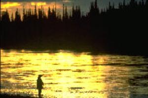
Sunset on the Thelon River
as a starting point as well. It has one hotel and several lodges, and there is a fishing lodge on Schultz Lake. Supplies are available at the Sanavik Cooperative. the Land Store and the Northern Store. Internationally renowned original Inuit carvings, prints, wall hangings and crafts can be purchased at the Jesse Oonark Arts and Crafts Centre, Ookpiktuyuk Art and Baker Lake Fine Arts. The community also offers outfitting services, and has developed hiking trails, a campground, a visitor reception and interpretation centre, and a traditional summer camp which demonstrates Caribou Inuit ways.
Apart from Yellowknife and Churchill ( pop. l 000), accommodation and services are also available in Chesterfield Inlet (300) Rankin Inlet (1700), Arviat (formerly Eskimo Point, 1300). Whale Cove (250) and Snowdrift (300).
Topographic Maps: The Thelon is covered by 1:250, 000 scale National Topographical Series maps: 56D (Baker Lk), 66A (Schultz Lk), 66B (Aberdeen Lk), 66C (Beverly Lk), 66D (Tammarvi R), 65M (Clarke R), 75P (Hanbury R) and 751 (Beaverhill Lk). Access lake maps include 75O (Artillery Lk), 75J (Lynx Lk) and 65N (Dubawnt Lk). For scientific research. there are 1:50,000 maps. Maps are available from: Canada Map Office, 615 Booth Street, Ottawa, Ontario K1A OE9; or, Mining Recorders Office, Dept. of Indian and Northern Affairs, Yellowknife NWT. X0E 1H0.
FURTHER INFORMATION
Thelon River - Services, Permits and Regulations: Economic Development and Tourism.
GNWT, Yellowknife NWT. X1A 2L9 (403-873-7115): Economic Development and Tourism,
Baker Lake, NWT, X0C 0A0 (819-793-2992): Economic Development and Tourism P.O. Box
002, Rankin Inlet, NWT, X0C 0G0 (819-645-5067); Canadian Wildlife Service, Box 2310,
Yellowknife X1A 2L9.
Tourist Information - Accommodation, Air Charters, Guides and Outfitters: Travel
Keewatin, Box 238 Rankin Inlet, NWT, X0C 0G0 (819-645-2618); Northwest Territories
Tourism, Yellowknife X1A 2L9, (1-800-661-0788); Baker Lake Municipal Council, Baker Lake,
NWT. X0C 0A0 (819-793-2874).
Canadian Heritage Rivers System: Member for Northwest Territories, Canadian Heritage
Rivers Board, c/o Director, Tourism and Parks, Economic Development and Tourism,
Yellowknife, K1A 2L9, or, Secretary, Canadian Heritage Rivers Board, c/o Canadian Parks
Service, Ottawa K1A 0H3.
Additional Reading:
- Travel Keewatin and Keewatin Chamber of Commerce. Canoe the Keewatin Wilderness, Available free.
- Hanbury, David. Life and Sport in the Northland of Canada. Edward Arnold Co.,
London, 1904.
- Whalley, George. The Legend of John Hornby. Macmillion, Toronto, 1962.
- Dienger, Carol. “The Timeless Thelon”. Up Here. Yellowknife, March/April 1990.
- Rossbach, George. “By Canoe Down the Thelon River”. Beaver. Outfit 297. Autumn, 1966.
- Thompson, Shelia. “Down the Thelon”. Borealis #34.
- Thompson, Shelia. 1990. Journal of a Barrenlander: W.H.B. Hoare. Box 4435, Station “E”, Ottawa K1S 5B4.
- Pelly, D. The Thelon. Currently in publication, Outcrop 1993.
THE CANADIAN HERITAGE RIVERS SYSTEM
The Canadian Heritage Rivers System is a co-operative program, developed and run by parks` administrations of federal, provincial, and territorial governments to give national recognition to the important rivers of Canada. The primary objective of the program is to ensure that rivers which are outstanding examples of Canada`s natural heritage which have played a significant role in Canadian history, or which offer outstanding opportunities for recreation' arc managed in such a way that their distinctive value is conserved while public use and enjoyment is enhanced
On January 19, 1984. the Canadian Heritage Rivers Board was established to administer the CHRS program and to review river nominations for inclusion in that program. The CHR Board currently is comprised of twelve members two appointed by the federal government and one appointed by each of the ten participating provincial and territorial governments. As of February 1, 1993, sections of 26 different rivers, with a total length of more than 6000 km, had been nominated to the System.
Nomination of rivers to the Canadian Heritage Rivers System may be made only by participating governments. However, private citizens or groups may suggest rivers to the responsible provincial or territorial parks' agencies