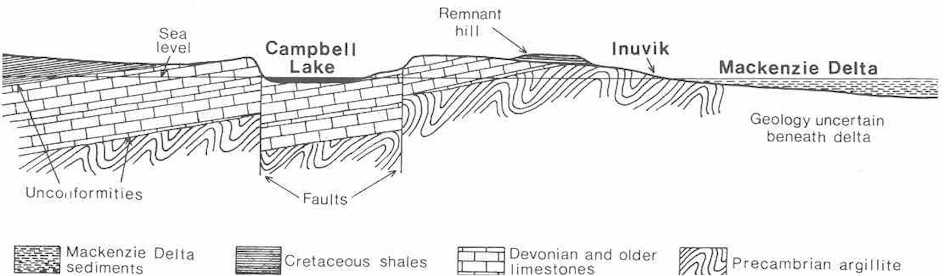
The remnants of shale that cover the limestones in a few places are a tiny sample of a huge sedimentary basin that is preserved under the Mackenzie Delta. In fact the Delta is merely the most recent stage in the accumulation of sediments in this basin. Sediment has been washing into it for at least the last sixty-five million years and has built up to a thickness of about 15 km. This basin is wedge-shaped in cross section, becoming thicker as the Beaufort Sea is approached. These sediments contain all of the gas and oil finds that have been made in the Delta or Beaufort Sea.
Shales are one of a family of rocks known as clastics. These sedimentary rocks formed from the erosional products of other rocks. Sandstones and conglomerates fall into this category. The coarser the fragments composing the rock, the faster must have been the currents moving them. From this knowledge and the distribution of shale, sandstones, and conglomerates, it is possible to interpret the environment at the time these sediments were deposited. Most of what is known about the rocks in the Mackenzie Delta sedimentary basin came from the wells drilled in search of oil and gas. A diamond drill bit makes an annular hole and the rock left in the middle is brought to the surface as core. This is very costly because the entire length of drill rod connecting the bit with the surface must be raised also. This may take several hours if the drill is deep. Therefore geologists working on the drill rig get cores only when they feel it is very important to examine the structures in the rock. Otherwise they must content themselves with the cuttings (rock chips) that are washed up the hole with the circulating drilling fluid.
It turns out that the structure of the sedimentary basin is quite complicated. It is a large basin that filled with sediment but, simultaneously, mountain-building forces were at work, disturbing the basin. The present delta contains mostly silt laid down by the twisting channels of the Mackenzie River. Below the delta surface the entire range of clastic sediments are found. Conglomerates indicating strong currents were present at the time of sediment deposition. Parts of the basin were raised by compressive forces to form land and streams ran off this land, redepositing sediment that had already been turned to rock. The raising of Campbell Uplift was probably happening at this time because shales that presently cap the uplift would have originated in a deep part of the basin, away from the direct sediment source of a river mouth. Shales that are the same age exist to the west and north of the Campbell Uplift under the Delta. The shales on the Uplift must have had time to be raised high enough so that erosion could expose them.
To observe one of the erosional remnants deposited during the disturbance
of the basin, walk 1.5 km south along an old access road that leaves the
Dempster Highway, about 100 m east of the limestone quarry. This road leads
to a quarry (Site 3) that was abandoned because the quality of the rock
turned out to be unsatisfactory for road construction. It turned out that
this rock weathers very quickly. It is a sandstone in which the sand grains
are only weakly cemented with calcium carbonate or pyrite. Both these
minerals are readily dissolved by water percolating through the rock. If
this happens the rock loses its strength. Chunks break down into sand so a
roadbed constructed of such material gradually collapses. Determining the
suitability of rock for construction is part of a separate field called
engineering geology.
| Figure 3. Generalized cross-section showing what a slice of the land would look like moving from Campbell Lake to the Mackenzie Delta. |
There is still enough of the quarry to let you see a record of an erosion episode that took place as the Mackenzie Delta sedimentary basin was being disturbed by mountain-building forces. The exposure is a record of a stream channel depositing sand, pebbles, cobbles, and plant remains over a more tranquil setting, perhaps a bog or flood plain. The flood plain layers are thin, less than one cm thick, with much organic material that forms black layers. Over this it seems that sand has suddenly been deposited in curved layers. A stream channel has appeared and would be changing course rapidly, in a matter of days or even hours. Sand would settle out on the stream bed, then the bed would move, perhaps to a place where it had been before, eroding the previous sediments. You can tell this if you follow a sand bed. You'll find that one sequence of beds is cut off or truncated by another, a sign that the stream was changing course and removing sand it had left earlier. Pebbles are spotted throughout, showing that the current must have been rapid. You might also notice that the thin organic beds below are not horizontal but have been compressed or squeezed. The stream washed in sand so quickly that the sediment beneath was still soft enough to collapse a bit under the added weight.
These sediments are tucked away in this low area between two limestone ridges, one to the south and one beside the road you walked in on. It is a protected pocket that survived removal by glacial erosion. Sometimes a small outcrop like this is all that is available for making interpretations of what happened. These rocks are clastic (formed from broken rock fragments), and they must be related to the much larger deposit of clastic rock that is the Delta sedimentary basin. The source of these particular sandstones has long been buried or removed and these pockets remain to give us clues that more than just one continuous building of sediment happened.