The St. Mary River is an important source of water for irrigation in southern Alberta. The St. Mary Irrigation Project was first conceived as a commercial venture by The Canadian Northwest Irrigation Company, organized in 1892 by E. T. Galt of Lethbridge and financed with British capital. Later consolidated under the name of the Alberta Railway and Irrigation Company, the organization took over a large block of land in the Magrath, Raymond, Lethbridge and Coaldale districts. This land was originally granted to the Galt interests by the Government of Canada as subsidies for construction of railways in the area.
By 1901, it was possible to irrigate 3,000 acres in the Magrath area and 600 acres near Lethbridge. By 1919, some 65,000 acres of land were being irrigated. The same year an agreement was reached with the A. R. & 1. to supply water to an additional 17,000 acres in the Taber district. Later, canal enlargements and other improvements were made and by 1942, a total of 127,000 acres of land were ready for irrigation. However, because of a lack of storage and irregular stream flow, only 120,000 acres were given water rights, and even this acreage suffered for lack of water in the late summer of most years. This occurred yearly until new sources of water was made possible through the development of the St. Mary Irrigation Project.
In 1935, when PFRA came into the picture, further consideration was given to the problem. On receipt of strong petitions from irrigation farmers in the area, PFRA engineers were instructed to renew investigations on the project.
At the outset, at least two major changes to the plan conceived by the Department of Interior appeared desirable: (1) locating reservoirs directly on rivers rather than inland, and (2) extending irrigation to the Medicine Hat area where climatic and soil conditions indicated great need.
Late in 1938, a site for the St. Mary Dam was located, and shortly thereafter a canal route was laid out across Forty-Mile Coulee and east over the Winnifred ridge to the Medicine Hat area.
The plan included reservoirs on the St. Mary and Waterton rivers, and several inland ones along the main canal. By 1941, general plans and tentative cost estimates had been completed by PFRA engineers. That year the Meek Committee was appointed by the federal government to look at these plans and report on feasibility. The committee report was published in 1942, recommending not only construction but the participation of the senior governments in the cost of the project. In 1945, tentative agreement on the sharing of costs was reached, and construction began, first on the Jensen Dam and the following year on the St. Mary Dam.
These principles were held to in the final agreement. Canada accepted full responsibility for the development of all main storage and diversion works and connecting canals as far east as Ridge Reservoir, as well as the provision of all engineering services required to develop the entire project. Alberta assumed responsibility for the construction of the main canals from Ridge Reservoir east, the distribution systems and inland reservoirs, as well as the settlement and agricultural development on the project. Alberta, however, recovers part of this capital cost from the farmers at a rate of ten dollars per irrigable acre.
Operation and maintenance of the federally financed portion of the project is conducted on a continuing basis by Canada, with delivery of water to the provincial works at a rate not to exceed 25 cents per acre-foot. Alberta in turn delivers water to the various irrigation districts and assesses the districts for transportation, operation and maintenance costs.
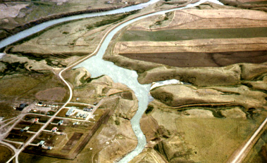
The key structure in the project is the St. Mary Dam, located on the St. Mary River about 35 miles southwest of Lethbridge. Further use of the St. Mary River wass dependent on this dam, which provides storage for not only the 120,000 acres already served, but also an additional 94,000 acres.
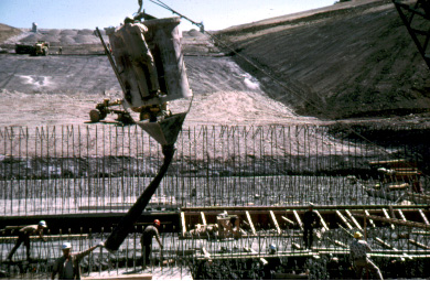
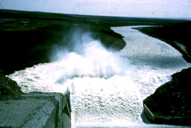
Construction was started by the federal government in 1946 and completed in 1951. The dam, which created a 17-mile long reservoir with a storage capacity of 320,000 acre feet of water, is of compacted earth fill construction, stands 202 feet high and is almost half a mile long. Water supplied from the reservoir is delivered by way of a 17-foot-diameter concrete tunnel to a main outlet canal serving the irrigation districts. Other major structures built along the extent of the canal system to balance flows and provide additional storage included the Chin, Jensen, Ridge and Grassy Lake Reservoirs. This represented the first stage in development of the water resources potential on the St. Mary Project.
The next step was to control the waters of the Belly River. This involved building a diversion weir on the Belly River immediately west of the St. Mary Dam, and excavating 27 miles of connecting canal to divert Belly River water into the St. Mary Reservoir. Started in 1956 and completed the following year, this development made it possible to extend irrigation to another 48,000 acres.
The final stage in construction was the damming of the Waterton River, and the construction of a canal to the Belly River, to provide additional storage and facilities for diversion of water into the over-all St. Mary Irrigation system. With completion of these works, the final step in the development plan to harness the water resources in these three major streams for irrigation was taken.
Construction of the Waterton Dam and other realted works began in 1958. A diversion tunnel was first required to pass the flow of the river around the area of the dam so that work could go forward. The diversion was accomplished in the fall of 1960, and then construction of the dam got under way. Now completed, this dam creates a reservoir with a total storage capacity of 140,000 acre feet of water. This, together with the diversion facilities provided, will make possible the development of remaining acreages of potentially irrigable land on the project.
For this success, much credit must go to the early Mormon settlers. Their zeal and enterprise, as well as their knowledge and experience in irrigation brought from Utah, set the stage for rapid progress in irrigation development within the area. The Mormon influence also contributed to the early lead that was taken in growing specialized crops on the St. Mary Irrigation Project.
Initially, emphasis was placed on sugar beets for which the local climate and soil were
well
suited. By 1905, the first sugar processing factory had been built at Raymond, south of
Lethbridge,
followed later by the establishment of a second plant at Picture Butte. Then, in 1950, with the
extension
of irrigation eastward, a third factory was established at Taber.
One major factor hampering development was lack of markets, with imported cane sugar providing keen competition. Later, import duties were imposed, favoring Canadian beet sugar producers. Similarly new specialized crops in the area moved slowly, with only gradual improvement in market opportunities. Nonetheless, by 1953 over 34,000 acres on the St. Mary Project were devoted to specialized crops. By 1959, this had increased to 70,000 acres and in 1967 to over 100,000 acres. As markets developed, new processing industries became established. Other major crops, in addition to sugar beets, were corn, peas, beans, potatoes, oilseeds, with small acreages of carrots and other vegetables.
Forage and legume crops were grown in rotation with specialty crops, and by-products from such crops as sugar beets, peas, etc., have encouraged the livestock industry. Livestock sales through the Lethbridge stockyards in 1967 amounted to approximately $56 million indicating the growing importance of this industry to the economy of the region.
PFRA's involvement in the St. Mary project ended in 1973 when Canada's interest in the project was transferred to Alberta under the Canada-Alberta Irrigation Rehabilitation Agreement. What was once a treeless waste has been transformed - thanks to irrigation - into one of the most densely populated and prosperous agricultural areas in Western Canada. And it has all happened within a period of 65 years.