Distribution of lands in Alberta, 1913 - Government - Canada at Scale: Maps of our History - Exhibitions - Library and Archives Canada
 Library and Archive Canada - Bibliothèque et Archives Canada Français | Help     Canada  
 Home > Browse Selected Topics > Canada at Scale > Government
  Important Notices  
Government Cartography

GO

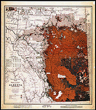
Distribution of lands in Alberta, 1913

The colours correspond with the status of lands (surveyed Crown lands, vacant private lands, lands owned by settlers, forest reserves, federal parks, Indian reserves, etc.). Identical maps of Alberta, Saskatchewan and Manitoba were produced between 1910 and 1930.

Catalogue entry:
Canada. Dept. of the Interior.
Alberta, southern : map showing disposition of lands / J.E. Chalifour, chief geographer ; prepared in the Railway Lands Branch. — 11th ed., corr. to Jan. 1st 1913. — Scale 1:792 000. — [Ottawa : Dept. of the Interior, 1913]. — 1 map : col. ; 93 x 83 cm, on sheet 105 x 91 cm. —

Ref. No.: NMC 011517

n011517k

Previous   Next Return to Canada at Scale