Township plan, 1889 - Government - Canada at Scale: Maps of our History - Exhibitions - Library and Archives Canada
 Library and Archive Canada - Bibliothèque et Archives Canada Français | Help     Canada  
 Home > Browse Selected Topics > Canada at Scale > Government
  Important Notices  
Government Cartography

GO

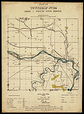
Township plan, 1889

The lands in the West were mapped before they were distributed to the settlers. The basic survey unit was the 36-square-mile township. Each settler was given 160 acres.

Most of the surveying was done between 1871 and 1885. More than 30,000 similar plans were produced. The township shown here is the one in which the town of Calgary, which was founded in 1876 and became a city in 1884, is located.

Catalogue entry:
Canada. Dept. of the Interior.
Plan of Township No. 24, range 1 west of fifth meridian : [Calgary] / compiled ... by Chs. Eug. Larue ... [et al.]. — 4th ed. (corr.). — Scale [1:31 680]. — Ottawa : Dominion Lands Office, 28th June 1889. — 1 map : col. ; 33 x 33 cm, on sheet 49 x 36 cm. — ([Township plans of the Canadian west]). —

Ref. No.: NMC 026423

n026423k

Previous   Next Return to Canada at Scale