Canada Land Inventory, 1963-1995 - Government - Canada at Scale: Maps of our History - Exhibitions - Library and Archives Canada
 Library and Archive Canada - Bibliothèque et Archives Canada Français | Help     Canada  
 Home > Browse Selected Topics > Canada at Scale > Government
  Important Notices  
Government Cartography

GO

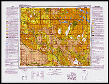
Canada Land Inventory, 1963-1995

The inventory was a federal-provincial project that lasted from 1963 to 1995. It produced maps which indicated the capability of land to sustain agriculture, forestry, recreation and wildlife. These maps cover all of Canada except the North. This document is an example of a capability map for agriculture.

Catalogue entry:
Canada Land Inventory.
73F: St. Walburg, Saskatchewan /cartographie réalisée par l’Institut de recherche sur les sols ... = cartography by the Soils Research Institute ... — Scale 1:250 000. — Ottawa : [Lands Directorate], 1974. — 1 map : col. ; 45 x 54 cm, on sheet 62 x 81 cm. — (Canada land inventory, soil capability for agriculture). —

Ref. No.: NMC 183940

n183940k

Previous   Next Return to Canada at Scale