|
About The Forum
Program
Speakers
Registration
Hotel and Travel
Contact Us
Sponsorship Opportunities
Sponsors
Webcast
Committee
Presentation Abstracts
Speaker Biographies
2005 Forum
|
|
Canadian <Metadata> Forum
Geospatial Metadata
Andrea Buffam
Natural Resources Canada
© Her Majesty the Queen, in Right of Canada, Natural Resources Canada.
Reproduced with the permission of Andrea Buffam. |
Available also in [PDF 1,128 KB]
The Presentation - Geospatial Metadata
This presentation will outline the 5 W's (who, what, where, when, why) and how, in the following order:
-
What
-
Why
-
Who/Where/When
-
How
Wrap-up
-
Recent Achievements
-
Current and Future Challenges
What is geomatics?
It encompasses a broad range of disciplines that includes:
-
Geographic information systems (GIS);
-
Remote sensing (data acquisition and application);
-
Mapping (photogrammetry, cartography, automated mapping, facilities management and charting);
-
Surveying (geodetic, cadastral, engineering and marine) and,
-
Global positioning systems (GPS)
What is GeoConnections and CGDI?
GeoConnections is a national initiative to make Canada's geospatial information accessible on the Internet. One of the main roles is to facilitate the creation of the Canadian Geospatial Data Infrastructure (CGDI).
The CGDI aims to be the main source for geospatial information and services in .Canada by working together with governments, private industry and academia to build and ensure fast, consistent and harmonized access to geospatial information and services for all Canadians.
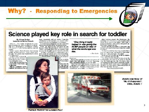
Why? - Responding to Emergencies

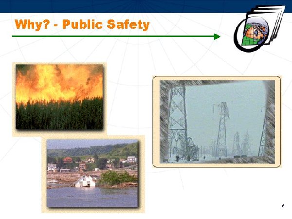
Why? - Public Safety

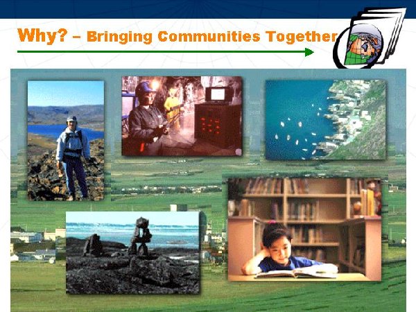
Why? - Bringing Communities Together

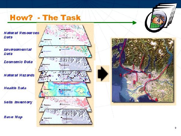
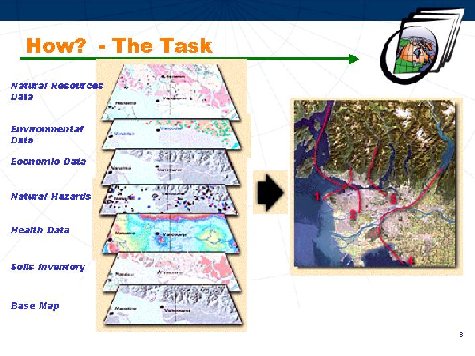
How? - The Task
-
Natural Resources Data
-
Environmental Data
-
Economic Data
-
Natural Hazards
-
Health Data
-
Soils Inventory
-
Base Map
Who is an access provider?
The GeoConnections Discovery Portal is the primary interface through which users can find and access (or visualize) data, organizations and services within the CGDI using a powerful spatial and keyword search engine.
Operations are based in the GeoAccess Division, Canada Centre for Remote Sensing, Natural Resources Canada.
The GeoConnections Discovery Portal is at: http://geodiscover.cgdi.ca.
How? - The Discovery Portal
-
The GeoConnections Discovery Portal system was built on the Canadian Earth Observation Network (CEONet) technology.
-
Valuable keyword and thesaurus tables were (continue to be) acquired (or developed) providing assistance to metadata providers and easing the search process.
-
Datasets are described using the Federal Geographic Data Committee (FGDC) metadata standard. [Fields are matched with the Directory Interchange Format (DIF) so exchanges to the International Directory Network can be achieved.]
-
Connections to distributed databases use Open GIS Consortium (OGC) standards to provide access to services and resources, such as web mapping services (wms), portals or geomatics software.
How? - The Discovery Portal Service
-
Content and connectivity co-ordinators monitor and assist metadata providers with population of quality entries in both official languages (English and French)
-
Staff is involved in developing metadata standards, interoperability and establishing thesauri
-
Reusable geographical tools, including gazetteers; APIs (including XML import/export); and, a WMS Viewer are available for designers to use, embed and integrate into their websites
-
As of September 1, 2003, GeoConnections Discovery Portal had the following published (client visible) entries:
-
1,920 Organizations
-
13,008 Data Products
-
463 Services (no service interface)
-
265 Searchable Collections (Z39.50)
-
64 CGDI Web Services (with service interface e.g. WMS)
How? - Metadata about Data
-
Federal Geographic Data Committee (FGDC) Content Standard for Digital Geospatial Metadata (CSDGM) and extended profiles:
-
Biological Data profile
-
Shoreline Metadata profile
-
Extensions for Remote Sensing Metadata
-
ISO TC211 19115
-
Contributing to a North American effort to produce a standardized implementation specification of the ISO 19115.
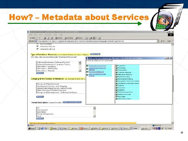
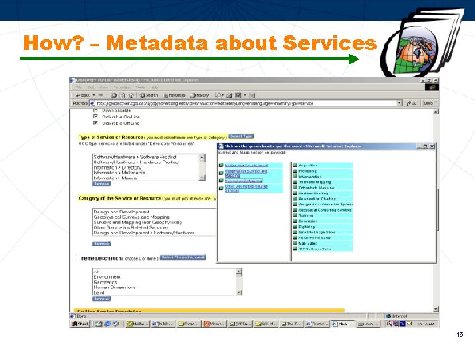
How? - Metadata about Services
-
Redesign of the Services component within GeoConnections Discovery Portal:
-
proprietary to standards-based.
-
enhanced discoverability and access.
-
Thesaurus selection process:
-
Investigated various services metadata standards and specifications- ISO 19119, OGC-OWS and CEOS IDN.
-
Researched potential keywords thesauri and Universal Standard Products and Services Classifications.
-
Engaged/consulted with other national and international colleagues.
How? - Metadata about Services
NAICS
The North American Industry Classification System replaced the U.S. Standard Industrial Classification (SIC) system. It was developed jointly by the U.S., Canada, and Mexico to provide new comparability in statistics about business activity across North America.
NAPCS
The new North American Product Classification System (NAPCS) is presently under development, with initial focus on products of service industries.
How? - Metadata about Services
-
North American Industry Classification System (NAICS) and North American Product Classification System (NAPCS) selected for services categorization scheme.
-
Extracted NAICS and NAPCS categories that met Discovery Portal requirements.
-
Internal working group defined new type and theme keyword categories, to support easy identification of client areas of interest and facilitate searches on the Discovery Portal.
-
Provided same categories (pull-down menus) to the services metadata supplier for excellent service identification.
-
Matched keywords to NAICS/NAPCS categories to ensure use of established standards. Ability to modify as required (upon advise/update from Statistics Canada)
How? - Metadata about Services
How? - Partnerships
Partnerships with all major federal and some provincial geospatial data providers and users are being implemented. Examples of current data-partners are ...
-
Indian and Northern Affairs Canada integrating the Northern Information Network into the Discovery Portal.
-
Atlantic Coastal Zone Information Steering Committee integrating information about coastal management
-
GeoNOVA to integrate Nova Scotia provincial and municipal entries
-
Canadian Geoscience Knowledge Network to integrate their data catalogue (data products and WMS)
-
NASA Global Change Master Directory to export the Discovery Portal Canadian metadata and import International information.
How? - Partnerships
Some Data-Use Partnerships include ...
-
Canadian Information System for the Environment (CISE), Environment Canada
-
Land Information of Ontario (LIO), Ministry of Natural Resources, Government of Ontario
-
National Forestry Information System (NFIS), Pacific Forestry Centre, Natural Resources Canada
-
National Land and Water Information System (NLWIS), Agriculture and Agri-Food Canada
How? - Training
Training ...
-
FGDC CSDGM metadata training course held in Ottawa - June 10 to12. Hands-on experience gained through use of the Discovery Portal as the metadata input tool. Presentations and Documents: www.geoconnections.org/CGDI.cfm/fuseaction/
devNetwork.workshops/pgm_id/25/gcs.cfm.
-
Eco-Instruct 2003 - Environmental Data Exchange in the Americas is being coordinated by Environment Canada and is scheduled for November 24 - 26 in Nova Scotia. Approximately 100 participants are expected. This 3-day workshop is based on the FGDC CSDGM Train the Trainer program using the Biological Data Profile. It is being offered in English, French and Spanish. Participants will learn about what it takes to become a successful environmental technical instructor using the latest environmental information management standards and programming techniques.
Recent Achievements
-
Provided the English and French versions of the GCMD Theme keyword thesaurus table (on the Discovery Portal) to the National Library of Canada for publication as an authoritative federal list of earth science keywords.
-
Developed and installed new Services metadata interface with keywords formulated by matching terms to the North American Industrial and Product Classification Systems (NAICS/NAPCS) categories (ensuring use of established standards).
-
Updated the Discovery Portal from the 1994 to the 1998 FGDC metadata standard and added ISO TC211-19115 related fields.
-
Prepared ISO TC211 19115 North American amendment proposal. Currently under review by U.S. and Mexico teams.
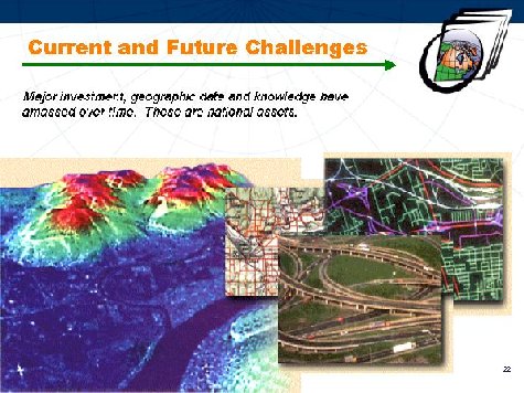
Current and Future Challenges
-
Monitoring the evolution of geomatics metadata standards and other industry activities to reflect ongoing development on the Discovery Portal for example, ISO TC211 19115.
-
Making recommendations for OGC-WMS metadata content and authority files, to promote discovery and access of web maps.
-
Involvement with new partners to continue increasing quick and easy access to geospatial data using the GeoConnections Discovery Portal.
- Continue to provide an IDN representative to the Global Change Master Directory Science Users' Working Group (GCMD UWG) for the American Coordinating Node.
Current and Future Challenges
Major investment, geographic data and knowledge have amassed over time. These are national assets.
Contact Information
|