 |
|||||||||||||||||
|
|
The La Vérendryes: Family of ExplorersExploration
|
||||||||||||||||
 |
| In 1732, the La Vérendyres set up two trading posts at Lake of the Woods Copyright/Source |
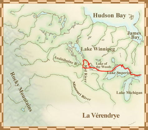
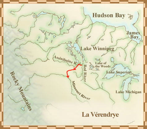
La Vérendrye became commander of the French fur trade's poste du Nord in 1728. He was curious about a way to find the western sea. The governor, Charles de Beauharnois, gave him permission to explore and set up trading posts. He left in 1731 and by 1732 he had reached Lake of the Woods and set up two trading posts.
Unfortunately, La Vérendrye had to spend much of his time handling the fur trade and creating good relationships with the First Nations. This left him little time for exploring. As a result, it took years to gain an understanding of the complicated lake and river networks.
 |  |
|
| La Verendyre was so busy with the fur trade that he had little time to explor Copyright/Source | It took years to learn about the complicated river and lake networks Copyright/Source |
In 1734, La Vérendrye returned to Montreal to calm the men who had given him money. They were angry because they felt he was not exploring enough. This problem, as well as those of running the forts and the fur trade, continued until he quit in 1743.
La Vérendrye Couldn't Win
La Vérendrye had always dreamed of finding the western sea, a way to China. He had a plan. The money he could make fur trading would allow him to explore. But, as he soon learned, if he stopped to develop trade he didn't have time for exploration. And without his fur-trading profits he couldn't finance his exploration.
Have Canoe, Will Travel
We know from La Vérendrye's journals that a Cree guide named Auchagah, also known as Ocliagach, traced a map for him using a piece of coal on birchbark. It showed the route between Lake Superior and Lake Winnipeg. It was a canoe route and showed everything a traveller needed, like a bus or subway map we would use today. With this map, and information from other Native people and his guides, La Vérendrye was able to explore what we now call Manitoba.
 |
 |
|
| A map drawn by Auchagah, a Native guide, for La Vérendrye (Page 1) Copyright/Source |
A map drawn by Auchagah, a Native guide, for La Vérendrye (Page 2) Copyright/Source |
 
|