|
|
Transportation18th CenturyShips and BoatsThe northwest coast of Canada presented special difficulties for European navigators. The coast was so far away from Europe that it took sailing vessels more than a year to reach it. Once they arrived, explorers found a rocky shoreline littered with islands and reefs, swept by uncertain winds, prone to strong tidal rapids and to wet, gloomy weather, and with few safe harbours for anchoring.
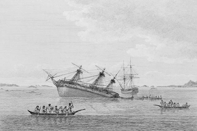
The Spanish met these challenges by using small sloops that could more easily navigate the inner passages of the coast. For example, when Dionisio Galiano and Cayetano Valdes explored Georgia Strait in 1792, they used schooners that were only 14 metres long, with crews of about 20 men. Such vessels were no bigger than many of the private yachts that cruise the same waters today. In contrast, James Cook's vessel, Resolution, was a 560-ton sloop of war with a crew of more than 100 men. And George Vancouver's ship, Discovery, was a converted merchant ship, 29 metres long, with a crew of 84 sailors, plus 16 marines. (A second ship, Chatham, was smaller but still bulky). These vessels were too large to manoeuvre through the narrow channels and up the steep-sided fjords. This fact was emphasized during the first summer of Vancouver's survey when both his ships grounded on reefs in Queen Charlotte Strait and came perilously close to sinking before they could be righted.
In response to local conditions, Vancouver worked out his own method of exploring the coast. Leaving his ships in protected anchorages, he and his men completed their meticulous, inlet-by-inlet survey in wooden longboats. These craft, six to seven and a half metres in length, were equipped with sails, but mostly they were rowed. They were absent from the "mother ships" for ten days to three weeks at a time. From before sunup until dusk, the sailors bent to their oars, fighting adverse winds and currents which in some places on the coast reached ten knots (about 18.5 kilometres per hour). During the first summer of the expedition, the men had no protection from the elements; they were drenched with rain, bitten by insects, and baked by the hot sun. In subsequent summers, awnings were erected that made the work slightly less uncomfortable. At dark they made camp on the rocky shore where they took celestial observations and enjoyed a short night's sleep. The third year of the survey took place mostly in Alaska where bitter cold, snow and ice were added to the litany of hardships with which the boat crews had to contend. One of Vancouver's biographers estimates that the longboats travelled a total of 16 000 kilometres along the coast before the survey was completed. |