


|
Maps
18th Century
The Pacific Coast
In the 1720s, by which time Russian fur traders had reached the Pacific coast, Russian tsar Peter the Great ordered a scientific expedition to the Far East in order to determine, among other things, whether Asia and North America were connected. Under Peter's successor, Catherine I, an expedition was launched in 1741 led by Vitus Bering and Alexsey Chirikov. They eventually charted the Bering Strait, crossed to North America, and reached 55°N on the Alaskan coast, proving that no land bridge existed. This expedition opened the coast of North America to Russian sea-otter hunters and claims of possession.
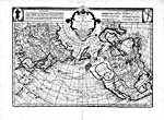 |
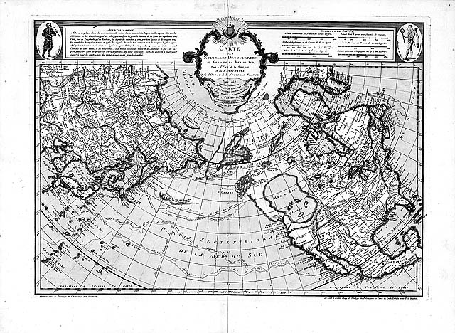
Carte des nouvelles découvertes du Nord
, by Philippe Buache, 1752
Copyright/Source |
In 1752, the French cartographer Philippe Buache published a map that showed Bering and Chirikov's route. Also on this map was the latest speculation about the "Mer de l'Ouest" and about a northeast passage from the Pacific to Baffin Bay ostensibly discovered by an Admiral de Fonte in 1640. Goaded by this map, which gave the credit for the discovery of the northwest coast to a Spaniard, the Russians finally published their own map.
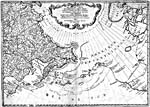 |
Nouvelle carte des decouvertes faits par des vaisseaux Russiens
, 1758, by Gerhard Müller
Copyright/Source |
To the south, the Spanish were growing alarmed that the Russians were making discoveries and laying claim to land which Pope Alexander VI had handed to Spain under the Treaty of Tordesillas (1494). Furthermore, although some Spanish scholars had proven the de Fonte story to be a myth, others decided that if a strait to Baffin Bay existed, Spain should lay claim to it. Although Spain had a foothold in California, their furthest penetration north had been Cape Blanco on the Oregon coast. In 1774 they sent their first expedition to the north under Juan Pérez, reaching 55°N. Bad weather and fog prevented a close examination of the coast. Subsequent expeditions charted the northwest coast but were not able to find a northeastern passage. By the time Vancouver arrived in 1792, Spain had sent ten expeditions up the coast but had done very little to publicise their discoveries with maps, even though their marine surveyors had done some fine work. This work did finally appear in 1792 but by this time Spain was losing interest in the area. War with Britain in 1796 ended Spanish involvement in the North Pacific Coast.
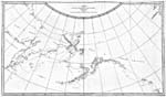 |
| Chart of the North West Coast of America and the North East Coast of Asia, 1778 & 1779, by Captain James Cook
Copyright/Source |
In Britain's growth as a global naval power it developed imperial and scientific interests. In 1778 James Cook arrived on the Northwest coast at 44°33' N, with instructions to determine whether a northeastern passage to Baffin or Hudson Bay existed. Over the next few months Cook ranged northward outside the string of coastal islands and through the Bering Strait to about 70°N, where he was stopped by ice. Although he did not check the coast in detail, he found it unlikely that any passage east existed.
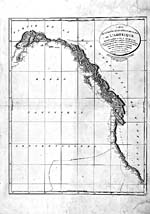 |
French copy of A Chart Shewing Part of the Coast of N.W. America
, by George Vancouver, 1798-1801
Copyright/Source |
The great charting expedition of the century was that of George Vancouver. His instructions were to make an accurate survey from 30° to 60°N, since Cook's was not detailed enough. Vancouver spent 1792 to 1794 making his survey over a very difficult coast. While surveying around Vancouver Island he met two Spanish ships, the Sutil and the Mexicana, engaged in the same objective. Having surveyed as far north as 59°12', Vancouver came to the conclusion that all the bays, inlets and river mouths he saw were dead ends. A northeastern passage did not exist. He passed the mouth of the Bella Coola River on June 4th, 1793, unfortunately missing Alexander Mackenzie, who arrived overland at the same place on July 22. Vancouver's charts were the best ones available until the middle of the next century.
SIGNIFICANT MAPS OF THE PERIOD
- Buache, Philippe
- Carte des nouvelles découvertes du nord... . [1752].
- [Galiano, Alcalá and Valdes, Cayetano]
- Carta Esférica de los Reconocimientos... . 1792.
- Müller, Gerhard
- Nouvelle Carte Des Decouvertes Faits Par Des Vaisseaux Russiens... . 1758
- Roberts, Henry
- A General Chart exhibiting the Discoveries made by Captain James Cook... . 1784.
- Vancouver, George
- A Chart shewing part of the Coast of N.W. America... . 1798-1801.
|