
Public Works and Government Services Canada
www.pwgsc.gc.ca
Common menu bar links
Esquimalt Graving Dock Waterlot - Sediment Remediation Project
Background
As part of the Federal Contaminated Sites Action Plan (FCSAP), Public Works and Government Services Canada (PWGSC) is remediating (cleaning-up) the contaminated sediments in the waterlot of the Esquimalt Graving Dock (EGD) to ensure the EGD meets federal and provincial environmental standards. The successful completion of this work will improve the marine habitat in Esquimalt Harbour.
The EGD is located on the north shore of Constance Cove in Esquimalt Harbour, at 825 Admirals Road in the Township of Esquimalt, BC. PWGSC is the federal custodian and operates and maintains the facility. The EGD has been used for the repair and maintenance of military and civilian vessels since 1927, and this long history of industrial use has contributed to sediment contamination in the seabed around the facility. The primary contaminants of concern identified from detailed site investigations include metals (e.g. arsenic, copper, lead, and zinc), polychlorinated biphenyls (PCBs), and polycyclic aromatic hydrocarbons (PAHs). Sodium and chloride ions (salt) from seawater, and other contaminants in lesser amounts, are also present. Based on the concentrations of the contaminants the classification for disposal purposes is waste quality IL+ soil (concentrations are greater than the BC Contaminated Sites Regulation Industrial Land Use standards); however approximately half of the material would be acceptable for use on industrial lands if the salt was not present. No Hazardous Waste level concentrations were identified. The sediments are acceptable for disposal at a facility permitted to accept waste quality soils.
For further information please see the PWGSC Esquimalt Graving Dock Detailed Site Investigation report (Golder Associates, June 7, 2013) in the Juan de Fuca Public Library.
Project
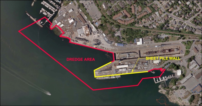
The project involves three phases: constructing an erosion protection sheet pile wall around the south jetty, which was completed in April 2013; dredging the contaminated sediment from the waterlot and disposal off-site at a permitted landfill, which will begin in June 2013; and creating new intertidal marsh fish habitat in Esquimalt Harbour, which is planned to begin in July 2013.
The dredging phase of the project involves the removal of approximately 150,000 cubic metres of contaminated sediment from the EGD waterlot. This contract was awarded to Tervita Corporation in January 2013.
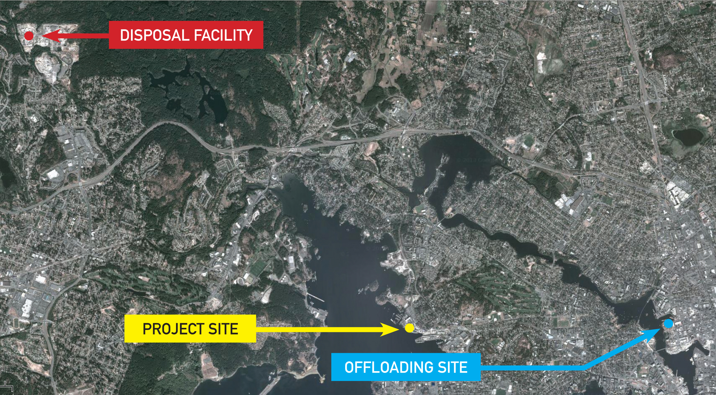
Dredged material will be transported from the EGD on barges to an off-load facility. Tervita plans to deliver the material to a private facility located in Victoria Harbour adjacent to David Street. The contaminated sediment will be loaded directly into trucks and taken to the Tervita Highwest Landfill located in the District of Highlands, BC.
An environmental monitoring program will help verify that the safeguards included in the project are protecting the environment during and after the clean up.
How Will This Project Affect You?
Dredging activities are planned to take place June 2013 - March 2014, six days a week (Monday through Saturday). Potential noise effects on the adjacent neighbourhood will be taken into consideration. The work hours will be similar to those of normal operations at the EGD, and noise levels will be monitored to follow the Township of Esquimalt's noise bylaw.
Additional vessel traffic is expected, including barges, which will be coordinated with the Department of National Defence and the Queen's Harbour Master to minimize inconvenience to boaters in Esquimalt Harbour.
Increased truck traffic through the community may be encountered in Victoria, Langford and the Highlands; truck routing will be planned to minimize impacts on traffic flow.
Contact Information
For more information on this project, please contact the Project Information Line at (250) 363-0227.
Current Work
- As of June 14, 2013, the planned work anticipates dredging at the Esquimalt Graving Dock starting on June 17, 2013.
- The contractor plans to use a marine clamshell dredge derrick to excavate the sediments, and then place them in water tight material barges. Once each material barge is full, it will be towed to an on-site Water Treatment Barge for dewatering of the sediment.
- Following sediment dewatering, it is then planned that he material barges will be towed to Victoria Harbour to a private off-loading facility located adjacent to David Street. The current schedule anticipates the first barge arriving at the off-loading facility on June 18, 2013.
- It is planned that the material barges will be unloaded using an excavator, and the sediments (now considered soil) placed into sealed trucks for transport to the Tervita Highwest Landfill facility located in the District of Highlands, BC. Trucking is anticipated to start on June 18, 2013.

Executive Summary
Public Works and Government Services Canada (PWGSC) completed a Detailed Site Investigation (DSI) through a third party consultant to support the remediation design for the Esquimalt Graving Dock (EGD) Waterlot Remediation Project. The below is a synopsis of the key findings. Should you wish to review the full report, please visit the Juan de Fuca Public Library.
Site Description and Background Overview
The EGD is the largest deep-sea shipbuilding and repair facility on Canada's Pacific Coast and has been operational since 1927 for the maintenance of private, government and military vessels. The EGD facility is located on the north shore of Constance Cove, in Esquimalt Harbour on the southern tip of Vancouver Island, within an area formerly known as Skinner Cove. Constance Cove and Esquimalt Harbour have a long history of naval and industrial activity, dating back to the mid-1800s. In 1921, PWGSC began construction of the dry dock at Skinner Cove, a natural rock basin on the north shore of Constance Cove. The dry dock was formed by blasting and removing bedrock, with the blast rock used as infill in areas surrounding the dry dock to reclaim the shoreline.
The EGD facility constitutes federal Crown-owned property, and is administered by Public Works and Government Services Canada. Esquimalt Harbour is administered by the Department of National Defence (DND) and is governed by the Canada Marine Act, Transport Canada's Natural and Man Made Harbour Regulations, and local practices and procedures. The Harbour Authority is the Queen's Harbour Master, Canadian Forces Base (CFB) Esquimalt.
Several environmental studies have been conducted since the 1980s within the EGD Waterlot and within the greater Esquimalt Harbour to assess sediment contamination. Sediment chemistry data collected as part of historical and recent investigations have identified the following key contaminants of potential concern (COPCs) within the EGD Waterlot:
- Light/Heavy Extractable Petroleum Hydrocarbons (LEPH/HEPH) and Polycyclic Aromatic Hydrocarbons (PAHs);
- PCBs;
- Metals: mainly arsenic, copper, lead, mercury, and zinc;
- Tributyltin (TBT);
- Methyl mercury;
- Dioxins and furans; and
- Organochlorine pesticides.
There is a wide distribution of COPCs within the EGD Waterlot; however, concentrations of chemical parameters are generally highest in areas adjacent to or beneath infrastructure (e.g., dry dock, South Jetty, Munroe Head and North Landing Wharf) and historical and/or ongoing industrial activity/operations.
A Detailed Quantitative Risk Assessment (DQRA) conducted for the Waterlot identified that metals, PAHs, TBT and polychlorinated biphenyls (PCBs) accounted for the majority of risk associated with contaminated sediments. Specifically, the DQRA noted that:
- Copper, total PAHs and total PCBs correlate to the majority of toxicity endpoints;
- Biomagnification of TBT, methyl mercury and PCBs in benthic organisms may result in potential ecological risk; and
- Arsenic, cadmium, copper, methyl mercury, TBT, PCBs and dioxins and furans could pose a risk for human consumers of seafood, especially crab.
There is currently a Fisheries Notice (FN0807) Consumption Advisory for Esquimalt Harbour (Area 19) dated October 19, 2009, which makes recommendations for limiting consumption of Dungeness crab, Red Rock crab, sea urchin roe and rockfish harvested from Esquimalt Harbour by sports fishers and subsistence populations, due to the presence of contaminated sediments in the harbour.
Overview of Detailed Site Investigation Results
The stratigraphic sequence in the Waterlot typically consists of unconsolidated sediments (a black organic silt layer and/ or grey clayey silt, both with varying amounts of anthropogenic debris), overlying grey clayey silt, silty clay and clay (upper fine grained marine sediments), overlying Victoria Clay (silty clay with some sand and gravel) overlying till (dense, well graded mixtures of sand, silt, gravel and clay) and bedrock. Coarser grained sediments (upper coarse grained marine sediments) are also present in areas along the North Landing Wharf (NLW), mouth of the dry dock and the South Jetty.
The typical stratigraphic sequence at the Site has been interpreted based on field observations (sediment core logs and borehole records), observation of samples, and the results of geotechnical laboratory analysis and in-situ testing. .
In areas along the NLW, mouth of the dry dock and around the South Jetty, coarser grained sediments (upper coarse grained marine sediments) and potential fill material were encountered. Beneath the South Jetty, thicker accumulations of unconsolidated sediments were encountered, together with granular suspect fill materials.
Contamination exceeding numeric remedial action objectives (RAOs) was typically associated with the surficial unconsolidated sediments, extending partially into the underlying upper marine sediments and in areas where coarser grained sediments or suspect fill were present. Contamination was generally located within the upper 1 to 2 m of sediment, however did extend deeper in some locations, usually where coarser sediments or fill materials were present (NLW, mouth of the dry dock, around and beneath the South Jetty), and in areas adjacent to or beneath facility infrastructure where intensive industrial activities were undertaken.
Concentrations of contaminants are observed to be highest beneath the South Jetty. Beneath the South Jetty, contamination exceeding numeric RAOs was encountered up to 6.71 m below mud-line (bml). In this area, PAH contamination was potentially associated with the presence of creosoted timber pilings. Other contaminants exceeding applicable guidelines beneath the South Jetty were recorded up to approximately 5 m bml (PCBs) and 6.5 m bml (metals). Organochlorine pesticides were measured at much higher concentrations in sediment samples collected from beneath the steel pipe piled portion of the jetty, with exceedences of up to 191 times the numeric RAO.
In addition, during the 2011 diver core investigation beneath the South Jetty, Hazardous Waste concentrations of PAHs were identified in two sediment samples analysed. In July 2012, additional sediment samples were collected from beneath the jetty to further assess the potential extent of Hazardous Waste concentrations of PAH in sediments. Hazardous Waste concentrations were not identified in the samples collected, confirming the extent was limited to the original two samples. This area is currently contained within a steel sheet pile erosion protection wall and is not being remediated at this time.
In less disturbed, open areas of the Waterlot, contamination was typically limited to surficial sediments (upper 0.5-0.6 m bml). These areas are also located away from facility infrastructure.
Higher concentration areas of contamination (>10 x RAO) were typically located adjacent to and/or beneath facility infrastructure. As identified above, concentrations of contaminants are highest beneath the South Jetty, which is not unexpected based on the historical uses of this area and reports regarding the historical disposal and burning of wastes.
The overall magnitude of contamination within the remainder of the Project Area was generally similar to the rest of central Constance Cove (in the range of approximately 2 to 5 times the numeric RAOs).
 Contamination Level Poster Board
Summary of Conclusions and Recommendations
The DSI has provided data on contaminant distribution within the Project Area to support the development of the remedial dredging plan for the EGD Waterlot Remediation Project, which involves full extent practical removal of contaminated sediments exceeding numeric RAOs.
Due to the presence of facility infrastructure adjacent to and within the Project Area, which is sensitive to undermining, and due to the depth of contamination present beneath the South Jetty and parts of the Munroe Head beach area, it is acknowledged that some un-disturbed residual contamination will remain in place following the remediation. However, the volume of contaminated material left in-situ will generally be limited in comparison to the volume being removed. It is understood that PWGSC intends to undertake an assessment of the environmental risks associated with undisturbed residual contamination, for long term risk management of the material (where necessary). As part of the design development for the future remediation of sediments beneath the South Jetty, it is recommended that options be assessed for the removal and segregation of material contaminated with Hazardous Waste concentrations of PAH.
With respect to TBT contamination in sediments, the proposed remediation will address a large portion of TBT contamination exceeding the moderate risk threshold for TBT in sediments. In the evaluation of the predicted TBT concentrations post-remediation relative to the current distribution of TBT in sediment, the current remediation footprint would result in a large reduction in the broad Constance Cove TBT concentrations. In other words, although not all of the localized moderate risk zones (hot spots) would be addressed, the weighted average TBT concentration in Constance Cove is predicted to decrease to less than the 0.75 μg/g dry weight threshold. Furthermore, it is anticipated that improvements in average sediment concentrations over smaller scales would be achieved following dredging, that appear to be ecologically meaningful relative to the current condition.
Many of the COPCs at the EGD Waterlot are considered "legacy" contaminants, i.e., they are associated with historical industrial activities, processes and products (e.g. additives in vessel hull paint) which are no longer in practice or use and therefore recontamination of the area with these contaminants is unlikely. These include PCBs, select heavy metals (arsenic, mercury, lead), TBT, methyl mercury, dioxins and furans, and organochlorine pesticides.
However, it is anticipated that there are potential ongoing inputs of COPCs to the EGD Waterlot, including PAHs (associated with treated timber pilings), hydrocarbons, and metals, mainly copper and zinc, associated with ongoing discharges from the EGD facility operations. TBT may also be a potential ongoing COPC, but would be expected to decline now that the application of paints containing TBT has been banned within Canada.
PWGSC continues to implement monitoring of operational discharges, including stormwater discharges, and undertake projects to upgrade facility infrastructure or management practices to further improve source control and potential discharges to the marine environment. PWGSC has implemented an ISO 14001 certified Environmental Management System (EMS) which includes Environmental Best Management Practices (EBMPs) that all contractors operating at the facility are required to adhere to.
Contaminated sediments from other parts of the harbour may provide a continued source of contamination however the magnitude of recontamination from harbour sources is likely to be reduced to concentrations currently seen within central Constance Cove (e.g., in the range of 2 to 5 times numeric RAOs). In addition, a harbour wide risk management strategy is being developed by DND, which is aimed at the longer term improvement of contamination within Esquimalt Harbour, with areas around DND shoreline being actively remediated through various proposed/planned construction projects
Questions and Answers
- How is this work being funded?
-
This work is being funded through the Federal Contaminated Sites Action Plan, which was created in 2003 to help federal departments and agencies manage risks associated with federal contaminated sites, especially those that pose the greatest risk to human health and the environment.
The objective of this project is to clean up contaminated sediments in the EGD water lot property and immediately adjacent areas.
Cleanup at the water lot is a high priority for PWGSC, due to the levels of contamination present and the potential for these contaminated sediments to migrate to other parts of the harbour.
Under the Canadian Council of Ministers of the Environment National Classification System for contaminated sites, the water lot has been identified as "Class 1 – High Priority – Action Required."
This project has been initiated in support of environmental due diligence and liability/risk reduction under the Federal Contaminated Sites Action Plan (FCSAP).
The primary contaminants of concern include metals (i.e., arsenic, copper, lead, and zinc), polychlorinated biphenyls (PCBs), and polycyclic aromatic hydrocarbons (PAHs).
There is no hazardous waste identified in the water lot area that will be dredged as part of this project. A limited amount of hazardous waste-level contamination has been identified in the area to be contained within the steel sheet pile wall that is being constructed as part of the current project. The containment will allow this portion of the remediation to be undertaken at a future date.
The primary source has been historical industrial activities such as ship repair and building, when work practices were not as carefully managed as they are today.
The current operations do generate copper and zinc residues, and improved site management procedures and environmental practices are in place to ensure these materials are contained and therefore reduce or eliminate potential future sources of contamination of the harbour sediments.
All operations at the EGD are required to comply with existing environmental legislation and standards. To further reduce the risk of environmental impacts from EGD activities, environmental management best practices are in place to provide added protection to the marine environment. These practices are taken very seriously and regularly undergo evaluations for continual improvement, as part of the ISO 14001 certified Environmental Management System (EMS). Improvements to the site infrastructure also help to reduce environmental impacts.
The project involves the installation of a sheet pile containment wall around the south jetty, as well as the dredging of contaminated sediments from the open water areas and disposing of them in licensed landfills.
A sheet pile wall is being installed around the perimeter of the south jetty to contain sediments under the jetty. Following the sheet pile installation, the dredging will be conducted throughout the open water areas of the water lot. After the dredging is completed, a sand layer will be placed over most of the dredged area to ensure a clean sediment surface following cleanup. Rock armouring will then be placed on slopes below the low tide mark where necessary. At the same time dredging is occurring, new fish habitat will be constructed at a separate location in Esquimalt Harbour.
The dredged sediments will be loaded onto barges, the water will be drained off, and the remaining material will be transported to an off-site area for disposal in accordance with applicable federal and provincial regulations. Sampling will be conducted after dredging to ensure that the cleanup was successful.
In September, PWGSC awarded a $6.5-million contract for the construction of the sheet pile wall to Salish Sea Joint Venture. Work began in October 2012 and was completed in April 2013.
For the second part of this project, PWGSC has now awarded a $38.6-million contract to Tervita Corporation to remove contaminated sediments in the water lot and transport them to licensed landfills. The dredging will be conducted starting June 2013 and is expected to be completed in spring 2014.
The open water remediation contract includes structure demolition and disposal; temporary structure relocation and re-installation; water-based dredging and removal of approximately 150,000 cubic metres of contaminated sediment and associated debris by barge; upland transport and disposal of contaminated sediment at licensed Canadian disposal facilities; and placement of clean sand and rock armour on portions of the seabed in the water lot.
A small portion of the contaminated sediment immediately adjacent to critical infrastructure cannot be fully removed without risks to the structural integrity of the existing dry dock or wharf structures. The limited residual contamination that may remain will be monitored as part of the site's long-term risk management plan in a way that will ensure a high level of confidence that risks to people and the environment are being addressed.
Overall, the project will result in a significant net mass reduction in contaminant levels in the harbour. It is possible that some recontamination of the remediated sediments may result from redistribution of sediments from other parts of Esquimalt Harbour into the project area. The EGD's environmental programs and best management practices are in place to minimize or eliminate the potential for recontamination from ongoing shipyard activities.
The project area was established to include the EGD water lot managed by PWGSC, and an additional zone extending 30 to 50 metres past the legal boundary. The intent was to include all areas that may contain contamination from historical operations at the graving dock.
The overall ecological rating of the water lot is "low." Kelp is present in some areas, but these areas form a small portion of the site. The results of detailed surveys conducted to detect sensitive species that may be present in the project area have been taken into consideration in the development of the project.
Kelp habitat is present in the area of Munroe Head beach between the low and high tide marks, where remedial excavation is proposed. The sheet piling around the south jetty will provide a temporary reduction in habitat quality, which will be compensated for with other habitat improvement projects, as required by Fisheries and Oceans Canada.
The work to be conducted at the EGD is expected to result in compliance with the Township of Esquimalt's noise control bylaw (No. 2677).
Dredging activities are expected to be conducted during normal work hours, with allowance for activities outside normal work hours, as long as they are in compliance with the noise control bylaw.
- Canadian Environmental Assessment Act screening-level approval;
- Fisheries Act Section 35(2) authorization; and
- Navigable Waters Protection Act approval for work in navigable waters.
As per the authorization for the project issued under the Fisheries Act, there will be no in-water work from April 1 to May 31 in any year, with the exception of installation of sheet piles and fender piles at the south jetty, which can be conducted in-water during this time. Any in-water works conducted outside the standard prescribed marine fisheries timing windows will be directed under supervision of a qualified registered environmental professional.
The first part of the work was the installation of the sheet pile erosion protection wall around the south jetty began in October 2012 and was completed in April 2013. The dredging and associated work will be conducted from June 2013 through to March 2014 and the last part of the project, namely the construction of new fish habitat, is expected to be done from July to September 2013.
Long-term monitoring will be initiated after completion of the cleanup, to confirm site conditions remain stable, and to monitor for recontamination. Sediment sampling will be conducted by PWGSC for at least five years, after which results will be reviewed and the longer-term monitoring requirements will be evaluated.
- improved condition of the project area sediments and associated sediment dwelling organisms due to the removal of the contaminants, resulting in healthier and more productive communities;
- reduction in the overall mass of contamination, resulting in a long-term reduction of harbour-wide contaminant concentrations;
- reduction in the potential for migration of project area contaminants to off-site areas; and
- reduction in ecological risk and risk for human consumers of seafood. However, other sources of contamination in the harbour may continue to require fish and shellfish consumption advisories.
As part of the sediment cleanup, the project will address contamination in the project area that has previously been identified as posing a potential ecological risk or a potential risk for human consumers of seafood. The cleanup of the contaminated sediments is aimed at reducing or eliminating unacceptable ecological and human health risks in the project area.
The project addresses contamination from the historical ship repair activity related to the operation of the EGD within the PWGSC water lot and immediately adjacent areas of contamination. DND administers the remaining portion of Esquimalt Harbour.
Providing opportunities for Aboriginal businesses is a priority for the Government of Canada, as outlined in the Government of Canada Procurement Strategy for Aboriginal Business announced on March 27, 1996.