|
|
|
|

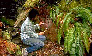
Rockhounding on Vancouver Island,
Vancouver Island, on the other hand, is about 20 miles offshore of the city of Vancouver, BC, and stretches like a long, flattened football up and down the coast. Its west coast is cut by deep fjords and steep, forested peaks, while its east coast (the one facing "over there") is flat and inhabited by less than half a million people. When my wife and I moved there, the general feeling among my rockhounding friends was "nice place, but poor hounding country". Boy, did we find out differently!
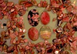
Rhodonite CountryVictoria is the provincial capital and home to half the total island population. If you go to any tourist store you'll see carved rhodonite figures -- bears, salmon, eagles.
"Where does it come from?" I asked many a store owner.But where exactly, no one seemed to know. After a lot of digging in the mineral titles office, I finally tracked down the two best known sites. "Hollings" was a small rhodonite quarry that Fred Hollings mined in the 50's and 60s. It's located on the southern end of Salt Spring Island, which means you have to take another ferry from Vancouver Island to get there. (Either Swartz Bay to Fulford Harbour, or Crofton to Vesuvius). Once on Salt Spring Island, it took us several weekends of hard hunting to track down the exact location. The locals had either never heard of it, or weren't telling. We never figured out which. The quarry itself has just been sold as part of a new housing project, so is now on private land, but there is still loose material laying around. Rhodonite (which is a manganese silicate, H = 6) weathers from brilliant pink to a black oxide that makes it tough to notice among the host basalts. A hammer blow can turn an otherwise dull-looking 'leaver' into that strawberry pink 'keeper' that just makes your heart leap. The Hollings quarry produced some of the best and hardest rhodonite on Vancouver Island, but it is by no means the only deposit.
To reach the Hill 60 Mine, you'll need a 4WD vehicle and a lot of courage. The last two miles of track up to the ridge are very steep and washed out, and the short track down the other side has a grade of about 1 in 1! But the views from the top, and the material to be found at the site, are well worth the effort, even if you have to walk those miles like we did, before I convinced rockhounding buddy Simon Deane to bring "Thunderpaw" (his 4x4) to haul us up the hill in comfort. Developed in 1919, the open face quarry on the steep south slope has a band of black manganese-rich material set in banded green and red tuffaceous cherts, with occasional lenses of jasper. A few thousand tons were taken out in the 20's, and then in the mid-80's prospector Earl Jacques took out more high grade material, which he had carved in China. Some of that material was so good, it was gem quality. Today, the mine is under claim, but inactive. Check with the Gold Commissioner's Office of the Geological Survey Branch in Victoria (250) 952-0542 for the latest information. At the west end of Hill 60 Ridge, another quarry just below the old fire lookout is worth a visit. Not nearly as steep to get to, the rhodonite content is lower, with more quartz, brown/yellow rhodonite, and psilomane.
Blood JasperRunning almost parallel to the rhodonite outcrops in the Sicker Formation are outcroppings of some of the North-West's best red jasper, shot through with white quartz. On the west side of Salt Spring Island there's a dyke that stretches up and down the hill over a hundred yards in length and ten yards wide, but the ownership of this remote deposit is unclear.Instead, better to head up the Chemainus River valley just north and parallel to the Cowichan Valley. South east of Reinhart Lake a large jasper outcrop butts right onto the road, sticking out through the spruce trees with no other rocks around. We heard about this deposit from Winnie Espitalier, who is the grande dame of rockhounding on the island. Canadian-born Winnie and her French aristocrat husband settled in Nanaimo in the late 40's. He was crazy about ocean sailing. After his death, Winnie felt she couldn't handle their huge sailboat alone. Instead, she developed a passion for rocks and minerals at a time when the hobby was unknown in these parts. Over the following four decades, she accumulated some incredible specimens. Today she can still point to a rock, casually placed in a corner of her garden, and tell you instantly when and where it came from. Despite Winnie's description of what we were looking for, and where it was, that huge jasper boulder next to the road looked too easy! On the third pass, we stopped and scraped away some of the layers of dust to reveal a stunning monolith that has to weigh 50 tons. It's still there. What can you do with 50 tons?
The first time we followed the creek upstream, looking for the source of that beautiful cutting material, we left the vehicle at the trench and walked, took several wrong turns, waded the stream twice (it was spring, and there was snow on the surrounding peaks), and generally had a great time getting nowhere fast. After a lot of bush thrashing, we gave up trying to keep dry, and just walked up Boulder Creek in our wet boots. At a particular point, the jasper in the river bed disappeared. After scouting around, we identified a small side creek just a few feet wide that had to lead to the source. Fighting our way up this for about 400 yards, we saw a clearing in the trees with a rock outcrop that looked interesting. On our arrival, we found a magnetite-hematite show (on the west slope of Coronation Mountain). While Simon primed his pipe and settled in for a quiet smoke, I scrambled around, sure the source of the jasper had to be close by. But after an hour of prospecting (Simon was back in the hunt by then) we came up empty. So, back to the little creek again. This time, we walked right in the stream (waterfalls, pools and deadfall notwithstanding), rather than take the easy option along the bank. A short distance below the magnetite outcrop we suddenly picked up fresh red material again, and by backing up, we found the jasper dyke right in the creek, covered in rich green moss. The red and green looked beautiful! Later trips to the site revealed that you can drive in from the north (past Ladysmith), and get your vehicle within half a mile of the deposit.
There's plenty of gold, so I've been told ...The great BC gold rush started in 1858, and took up the slack for the California 49'ers who hadn't made it there. Most of the newcomers headed inland to the Fraser River, the Cariboo, and later the Klondike, but what a lot of people don't know is there was a gold discovery just west of Victoria, in 1864. Named after a Lieutenant Leech in the British Navy, Leechtown quickly grew to over 3,000 men, and then just as quickly disappeared again. But the alluvial gold still washes out of the quartz host and can be found in the creeks from Sooke River west to the San Juan River. One of the best rivers is Loss Creek, about 50 miles west of Victoria. The paved coast road is empty and close to the sea much of the way, with spectacular views across Juan de Fuca Strait to the Olympic Mountains in the state of Washington to the south.Don't pan in the Loss Creek Provincial Park (it's illegal to pan in parks or on Indian reserves), but there's an unpaved road heading up the Loss Creek valley. A mile upstream of Highway 14 there's plenty of scope to try your hand looking for that flash of color in the bottom of the pan. There are also red/pink garnets and black sand (magnetite). Another good gold location is on Meade Creek, which flows into Lake Cowichan just a few miles west of the town of Lake Cowichan. Highway 14 to Youbou (pronounced yoo-boo) cuts the creek, and you can walk upstream from there. Better access is by driving back to town half a mile and heading up a dirt track past the town's recycling plant. After a mile, the road and creek are close, and you can clamber down to the big pools to work the sands and gravels. Keep a sharp eye out for jasper, banded chert and rhodonite, which are found in the mountains drained by the creek.
Welcome to Fossil CountryThe geology from the city of Nanaimo north to Campbell River is sedimentary. Nanaimo was founded on the discovery of coal in 1849. Much of it was used to fire the new boilers of the expanding Pacific merchant marine. The rest went south to California, which was growing at an unprecedented rate. At the turn of the century, the discovery of oil in the lower states and the Middle East changed the economics of coal, and Nanaimo slowed down.Some miles north of the city, on a small island in the straits between Vancouver Island and the mainland, spectacular marine fossils were being discovered. Today, the northern tip of Hornby Island, called Phipps Point, has an extended horizontally bedded shelf that is exposed during spring tides. Fossils can be found in large metamorphosed mud nodules. A pair of wading boots, a hammer, and a sharp eye on the incoming tide are all you need to spend a pleasant day fossicking for fossils. Some of the very best specimens can be seen at the Vancouver Island Paleontological Museum in Qualicum Beach, where you can sometimes meet Graham Beard, school teacher, founder of the museum, and co-author of West Coast Fossils - a Guide to Ancient Life on Vancouver Island. An hour's drive further north on Highway 1 brings you to the Courtney and District Museum in Courtney. This now has an impressive exhibition of fossils, including a 50 foot Elasmasaur (a marine dinosaur) and ancient turtles, all found close to the city. There, you can meet director Deborah Griffiths and twin paleontologists Pat and Mike Trask. It was Mike who found the first Elasmasaur, which set off the fossil frenzy in the area. He organized whole classes of school kids to help with the digs each summer, so that today there are lots of very proud youngsters who have a personal stake in the exhibits that the museum puts on display. Mike and his daughter's story of the discovery can be read in Heather's Amazing Discovery, available at the museum.
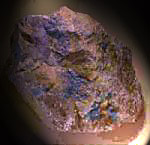
The Ultimate BluesThere are very few blue semi-precious gemstones in the world - sodalite, lapis and turquoise are the best known, although Brazil produces some nice (natural) blue quartz too. To this short list you should add the name of dumortierite, a mineral not often seen. With a deep blue color and a hardness of 7-8, this aluminum borosilicate is found at the contact zone between the volcanics and a quartz feldspar porphyry dyke near the town of Port Hardy, at the very north end of the island.
Today, the site is being reclaimed; trees and grass are being replanted, and the exact future of the area is not clear. Since the mine and dumps cover many acres and are right on an inlet, anyone can come ashore and rockhound, even if the gates on the Port Hardy road are closed. The pit has been flooded with sea water, but there is a mountain of material to be found everywhere - pyrite cubes in tuff, chalcopyrite, molybdenite crystals, bornite, sphalerite and galena are common. Look where the smooth grass fields are: they are the old dumps. Above the western end of the flooded pit are a series of steep terraces, and pretty much right in the middle, dumortierite and quartz material can be found in a breccia zone that is made up of massive gray-tan pyrophyllite, with a coarse, gritty texture.
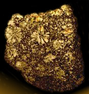
Rare MineralsIt's tough to write about rare minerals, because there's always someone out there who has a whole yard full of whatever it is, and reckons the stuff is as common as leaverite. Notwithstanding that, here's a list of some of the less common minerals that have been identified on Vancouver Island:Analcite (Analcime): small, white, trapezoidal crystals up to 1/4" in diameter have been found in marine fossil deposits at a roadcut on Highway 14 west of Victoria, together with an as-yet unidentified yellow rhombohedral crystal that is not calcite. Cooperite: this extremely rare platinum sulphide has been identified at the old Mt Washington mine site near Courtney, one of only two locales in the world. Volborthite: this vanadium mineral has been found just north of the town of Campbell River. Cinnabar: found at two different sites. One is near Wolf Lake, close to Mt Washington. The other is on the west coast, and can only be approached by boat from Tofino. Quartz crystals: well formed, clear quartz crystals up to 6" in length, some coated with green epidote crystals have been found around the Adam and Eve Rivers in the north of the island. Druzy quartz has been discovered in the Port Alberni area.
Geological History of Vancouver IslandThe first thing you'll notice about the rocks on Vancouver Island is that they are very different from the mainland. No soaring granites like the Cascades, no cindery volcanoes like Mt Baker or Rainier. The island is noticeably different. Why? Because it belongs to a separate terrane called Wrangellia, which includes the Queen Charlotte Islands, and part of SW Alaska.It all started about 380 million years ago in the Devonian Era. And it started a long way away from where Wrangellia is now. Somewhere out in the Pacific, possibly close to where Hawaii presently is. Like those tropical islands, Wrangellia began as a series of undersea volcanic eruptions. Unlike Hawaii, not many reached the surface. Huge amounts of ash (green tuff) spread across the sea floor. Geologists estimate this went on for about 20 million years, after which everything cooled down, leaving the rocks of the Sicker Group, which today are exposed on Salt Spring Island, the Cowichan Valley (including Mt Sicker N of Duncan, which gave its name to the structure), and the Myra Falls/Lynx mine in Strathcona Provincial Park. From then until the start of the Triassic Era, 245 million years ago, the shallow waters of the newly formed sub-sea islands eroded and weathered, plants and marine animals lived and died, and layers of limestone built up. Today these are visible near Victoria, at Mt Mark, on Buttle Lake and elsewhere. Curiously, there are no rocks on the island around the start of the Triassic Era (245-235 million years ago). Perhaps they all weathered away. And then again, perhaps not. However, about 230 million years ago the crust appears to have split apart, and huge masses of fiery lava oozed out, cooling quickly into black basalt (pillow lavas) called the Karmutsen Formation. This is the thickest layer found on Vancouver Island. As more and more lava rose and spread outward, the entire region was covered in such thick layers that after 5 million years, when it all slowed down, the topmost layers were close to the surface. Perhaps the best example of these lavas is Mt Arrowsmith, a high, domed cluster of peaks between Parksville and Port Alberni. As the Triassic came to an end and the Jurassic saw the arrival of the first dinosaurs, mammals and birds (210 million years ago), more lava flows pushed Wrangellia above sea level, forming the Bonanza Group. At the same time, other magma pushed up from below. Although it failed to reach the surface, the heat cooked (metamorphosed) the deeper rocks (in the Sicker Group), turning some to gneiss (that's nice). Evidence of this can be found on Mt Tolmie in Victoria. Limestone also metamorphosed to marble, as at Port Renfrew. Up until the late Jurassic, the forces working on what would later come to be known as Vancouver Island were mostly eruption and erosion. But something else had been taking place, quietly in the background, for almost 300 million years ... plate tectonics. While volcanoes were spreading thick layers of rock across the sea floor, the sea floor itself (and the volcanoes) were moving slowly and steadily NE, until about 100 million years ago they ran into the North American Plate, which was itself heading West. What happened next changed significantly the way Wrangellia looked, because suddenly huge forces began to twist and shove and lift and squeeze the terrane. Fault lines developed, such as the ones along the Cowichan Valley, and up Buttle Lake, and mountains rose along the island's centre. Newly eroded material washed into the closing gap of Georgia Strait, forming a series of shallow basins, part of the Nanaimo Group, where coal would later be discovered. With the Wrangellia Terrane basically stopped by the North American continent, another plate (the Crescent Terrane) came gliding along and slammed into the back of Wrangellia, about 42 million years ago (just like cars on a foggy highway). These new rocks can be seen from Metchosin to Loss Creek, and are known as the Metchosin Igneous Complex. Since then, most of the changes to the island have been small -- an eruption here, a magma flow there. Nothing to write a book about. The final chapter in this continuing saga is the arrival of at least three ice ages, which dramatically changed the surface of Wrangellia/Crescent, leaving it much as we know it today. The last ice sheets retreated to Vancouver only 12,000 years ago, which in geological time, is about yesterday.
Suggested Readings
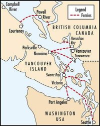
How to Get ThereTo reach Vancouver Island, you'll have to catch a ferry from one of several ports. Schedules vary, depending on the season, so it's best to phone ahead and get the latest information:
When to VisitThe island has a mild winter, but that still means 12 feet of snow atop those 7,000 ft high peaks in January. The snow is off the low areas in February, the alpine by May. There are no grizzlies or rattlesnakes (some black bear). Best months to visit are May to September. July and August are busy at the ferries. If you combine it with watching the salmon runs, come between September and November.
This article may not be copied, distributed or reprinted in any form without permission the author and the editor of Rock & Gem magazine. To contact the author, please use the e-mail address provided. If you are unable to contact the author, please contact the Canadian Rockhound. Authorized reprints must acknowledge the author, Rock & Gem and the Canadian Rockhound, and include the website URL address of the Canadian Rockhound. Reprinted in the Canadian Rockhound with permission from Rock & Gem. To contact the author by snail mail, please use the following address:
Rick Hudson, Document Number: CR9701308

Copyright ©1997 Canadian Rockhound
Images of minerals are Copyright ©1996
theImage.com
Magazine Issues |
News & Events |
Junior Rockhound |
Resources
|