| About us | Contact us | Services | Copyright | |||
| Back Issues | News & Events | Junior Rockhound | Resources | Clubs | Dealers | Web Links | Home |
| |||||
| |||||
| |||||
|
Copyright / Reprints A Mystery in the Mountains: What Really is the Howell Creek Structure? By Darren P. Maine, CET
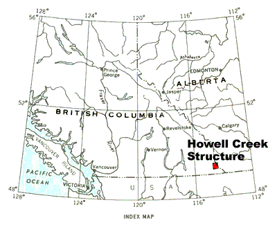
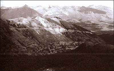
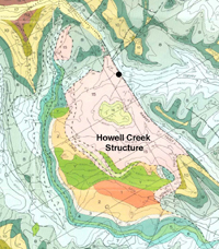
Sometime before the death of the last dinosaur on earth I believe that something very big happened in the Flathead Valley of Southeastern British Columbia. Something so big that nearly 235 million years of geological history (on the order of 1,400 m to 3,050 m of strata) were erased from upwards of 75 sq. km of what would become the MacDonald Range of the Rocky Mountains about 42 km southeast of Fernie, BC. And the only evidence remaining to attest to this great event today is what we call the Howell Creek Structure or HCS (Figure 1).
Since the description of the HCS in detail by Dr. R.A. Price in Geological Survey of Canada Memoir 336 the structure has remained an enigmatic and controversial feature among Cordilleran geologists. Such description is of great significance though because it is only through a cohesive structural model that the economic potential of the HCS and similar structures can be fully assessed. Because of my long interest in the HCS and the associated Howell Creek Intrusive Complex (one of only two major intrusive complexes known in the Canadian Rockies with the other being the better known Ice River Complex in Yoho National Park) I have decided to fulfill my senior project requirements toward my BSc studies with Athabasca University by focusing my work on seeking an answer to what one of the most enigmatic features in the Canadian Rockies, the Howell Creek Structure, really is. Is it time to close the door on a window at Howell Creek?
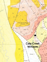
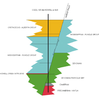
The HCS was mapped by Price as one of three tectonic windows in the Flathead mapsheet area; the other two are found east of the Flathead River on Cate Creek and Haig Brook respectively in the Clark Range of the Rockies (Price, 1962, 1965). Windows are unique to overthrust areas where erosion has penetrated a thrust plate and exposed the younger rock underneath. Because the younger strata which would otherwise be buried under the older strata is now visible through this hole, a tectonic window is said to exist. The Cate Creek window (Figure 2a) exposes Cretaceous Alberta Group (80-100 Mya) within a window of overlying Proterozoic Purcell Supergroup strata (in excess of 570 Mya) at a location approximately 13 km east of the HCS. The Proterozoic is believed to have been emplaced by the Lewis Thrust thus a continuous sequence of strata from the Cretaceous through to the Proterozoic was anticipated should the window be drilled. This model was confirmed when such a continuous stratigraphic sequence was found to underlay the window when the Shell Honolulu Flathead b-22-A was completed in 1960 (Figure 2b).
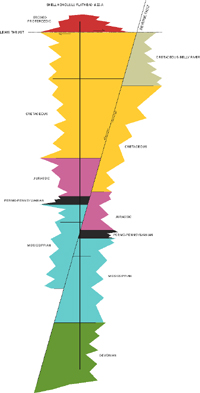
Superficially then it is easy to see why the HCS could be considered a window similar in nature to the one at Cate Creek (Figure 3a). Cretaceous Alberta Group is exposed within an apparent window of older Paleozoic Mississippian and Devonian strata, though in this case only isolated outliers of older Precambrian Proterozoic Purcell Supergroup rocks are present within the structure itself. Thus, this and other factors led Price to conclude that the Paleozoic and Proterozoic rock at the HCS were also likely remnants of the Lewis Thrust sheet and that the HCS in turn was described as a tectonic window. When the CIGOL 10E etal Howell a-16-B was drilled on the northeastern edge of the structure in 1970 though, it was found that the HCS was far more complex than previously assumed. Based on this unexpected turn and in conjunction with additional examination of the structure, Dr. P.B. Jones presented a radically new explanation for the genesis of the HCS in 1977. It was this paper that served as the seed for the model that I am proposing today. An Idea of an Impact
Jones found that contrary to the continuous stratigraphic column expected for a tectonic window, the CIGOL well had shown that the HCS was not stratigraphically continuous (Figure 3b). Rather an unexpected unconformity was encountered when the well passed directly from 90 MYa Cretaceous Cardium sandstones into 325 MYa Mississippian Rundle Group limestone. This unconformity represents a geochronological gap of nearly 235 MY in the strata making up the HCS. This is equivalent to approximately 1,400 m of missing rock based on equivalent sections from the Shell MacDonald d-30-H located southeast of the CIGOL 10E; Jones suggests up to 3,050 m of equivalent section could be represented within this unconformity.
As a result of his findings, Jones concluded that the HCS was not a window at all. Rather, he hypothesized that the structure was originally a marine or lacustrine trough on the order of 458m deep in which an 8 cubic kilometer Paleogene landslide was deposited. He explained that the scattered Proterozoic outliers within the structure were actually megabreccia blocks which are remnants of this slide. Of the preliminary work that Jones completed in synthesizing this new model of genesis for the HCS he left a number of key questions to be answered by future investigators; the one that caught my attention was "what was the origin of the basin into which the slide came to rest?" Though the concept is still in its infancy, I believe that the HCS is the footprint of a complex marine impact crater that was originally on the order of 10 km in diameter. Dating of the impact is still uncertain though it appears to be of Cretaceous age. This age assumes that the impact occurred after the intrusion of the 97 Mya Howell Creek syenites (I believe that the unusual exposure of the complex was due largely to excavation and sliding initiated by this event) but preceded deposition of the 90 Mya Cardium sands. The truncation of the structure occurred when the Harvey Fault roughly bisected the basin and uplifted the eastern quadrants on the footwall of the fault. The removal of this segment of the structure from the protective basin in which the western segment remained exposed it to erosion and its ultimate loss from the geological record. I believe that the wasting of the eastern quadrants of the structure contributed essential detrital materials to the generation of the Kishenehn-like breccia/conglomerates found in the Eastern Outlier of the structure (Jones, 1977). As these rocks appear to be isolated to the HCS I believe that they may provide important mineralogical clues either for or against this model and as a result will receive intense scrutiny. And I believe that Jones' Paleogene slides (though this dating requires some reassessment as the primary rim sliding and megabreccia generation associated with the impact event would also have been Cretaceous in age) are not inconsistent with this new model. The ongoing deformation and shaping of the structure could easily have triggered sliding due to recurring rim collapse as the Laramide Orogen continued to mold and shape the structure into the truncated, ellipsoidal form we see today. As with any hypothesis the challenges and questions abound and so they should. It is a place to start though on this journey of discovery. And by following the map that has been preserved within the rocks, the folds, the minerals, and the many mysteries yet to be unmasked I hope, like these dedicated investigators before me, to add a little more to the understanding of this remarkable mystery in the mountains, the Howell Creek Structure. References:
Acknowledgements:
After many years of silent reflection and my love for the science of geology I have had the opportunity to chase a dream, and one day, hopefully achieve my BSc from which I will continue to pursue the answers to this mystery in the mountains. I am indebted to my 10 year old daughter, Olivia, and her stout-hearted rock "hound" Tripper, and Carol for their steadfast enthusiasm and support in my studies, and as my unflagging "partners in grime" with whom I have scaled and scoured many an outcrop while rediscovering with them the world in which we live one sample at a time. A special thanks is also given to the Minister of Public Works and Government Services and the Geological Survey of Canada for their kind permission to reproduce mapping and aerial photography from Memoir 336 which was essential in presenting this article. And without the outstanding assistance and ongoing support of Mr. Steven Glover, Data Centre Supervisor, Mr. Derek Brown, New Ventures, and Mr. Steve Roberts, Assistant Deputy Minister of BC Energy and Mines my research and work in the Flathead Valley would not have been possible.
Golden Jaguar Explorations, Limited Reprint instructions: This article may not be copied, distributed or reprinted in any form without permission from the author. To contact the author, please use the e-mail address provided. If you are unable to contact the author, please contact the Canadian Rockhound. Authorized reprints must acknowledge the author and the Canadian Rockhound, and include the website URL address of the Canadian Rockhound.
MAINE, Darren. A Mystery in the Mountains: What Really is the Howell Creek Structure? Canadian Rockhound [online]. 2003, vol. 7, no. 2. Available from World Wide Web: <http://www.canadianrockhound.com/2003/02/cr0307203_howellcreek>.
Copyright © 2003 Canadian Rockhound Winnipeg, Manitoba, Canada
Back Issues |
News & Events |
Junior Rockhound |
Resources
|
||||||||||||