| Regional Summary | CTVB Archive | Français |
| |
| The
Green Lane | CARD | | Regional Summary | CTVB Archive | Français | |
 Autumn 1998 Temperature and
Precipitation in Historical Perspective
Autumn 1998 Temperature and
Precipitation in Historical Perspective  For the third consecutive season, autumn 1998 in Canada
was the warmest on record. The national average temperature for the three months
(September, October, November), based on preliminary data, was 2.3°C above normal.
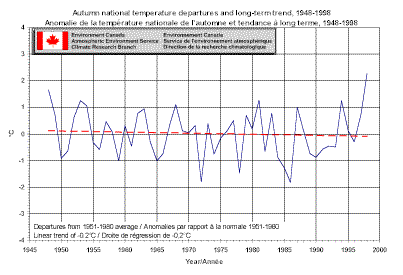
The autumn national temperature departures table shows 1948 was
the second warmest autumn, at 1.7°C above normal, out of the 51 years since comparable
nationwide temperatures records began in 1948. The coolest autumn was 1986 at 1.8 below
normal. Statistically, in an unchanging climate, Canada could expect an autumn anomaly
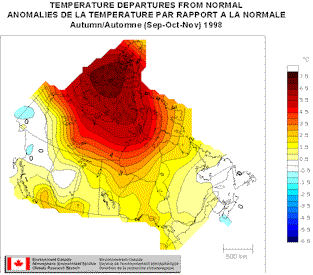
like this autumn’s about every 170 years. Most of Canada experienced temperatures
more than one degree above normal. The Arctic islands felt temperatures more than
5°C above the long term average. Only southern Yukon, Northern British Columbia,
central Alberta and most of the Maritimes experienced normal or slightly below normal
temperatures this autumn. Even with this record warmth, the linear trend for autumns
is still slightly negative, -0.2°C over the 51-year period. Nationally, over the last 20
years the number of autumns above normal and below normal is even. The consecutive seasons graph shows this autumn extends the
above-normal streak to six seasons.
For the third consecutive season, autumn 1998 in Canada
was the warmest on record. The national average temperature for the three months
(September, October, November), based on preliminary data, was 2.3°C above normal.
The autumn national temperature departures table shows 1948 was
the second warmest autumn, at 1.7°C above normal, out of the 51 years since comparable
nationwide temperatures records began in 1948. The coolest autumn was 1986 at 1.8 below
normal. Statistically, in an unchanging climate, Canada could expect an autumn anomaly
like this autumn’s about every 170 years. Most of Canada experienced temperatures
more than one degree above normal. The Arctic islands felt temperatures more than
5°C above the long term average. Only southern Yukon, Northern British Columbia,
central Alberta and most of the Maritimes experienced normal or slightly below normal
temperatures this autumn. Even with this record warmth, the linear trend for autumns
is still slightly negative, -0.2°C over the 51-year period. Nationally, over the last 20
years the number of autumns above normal and below normal is even. The consecutive seasons graph shows this autumn extends the
above-normal streak to six seasons.
Following the autumn precipitation section, there is a summary of the first 11 months of the year.
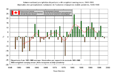
 The Autumn of 1998 was a balance between much above normal
and much below normal precipitation. The net result was an autumn that was 17th
driest at 1.5% below normal. The autumn national
precipitation departures table shows that the driest autumn nationally was in 1976
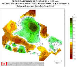
(-20.3%) and the wettest was in 1981 (+24.1%). The accompanying map shows the wetter
than normal areas are southern British Columbia, central Alberta, southern Saskatchewan,
and some of the Maritimes. The rest of the country is either above or near normal.
It should be noted that "normal" precipitation in northern Canada is generally
much less than it is in southern Canada, and hence a percent departure in the north
represents much less difference in actual precipitation than the same percentage in the
south. The national precipitation rankings are therefore often skewed by the northern
departures and do not represent rankings for the volume of water falling on the country.
In the last ten years only this autumn and the autumn of 1993 were below normal.
The only other autumn in the last 20 years with a below normal value was 1987. The consecutive seasons graph shows that the four seasons in 1998 have
been below average.
The Autumn of 1998 was a balance between much above normal
and much below normal precipitation. The net result was an autumn that was 17th
driest at 1.5% below normal. The autumn national
precipitation departures table shows that the driest autumn nationally was in 1976
(-20.3%) and the wettest was in 1981 (+24.1%). The accompanying map shows the wetter
than normal areas are southern British Columbia, central Alberta, southern Saskatchewan,
and some of the Maritimes. The rest of the country is either above or near normal.
It should be noted that "normal" precipitation in northern Canada is generally
much less than it is in southern Canada, and hence a percent departure in the north
represents much less difference in actual precipitation than the same percentage in the
south. The national precipitation rankings are therefore often skewed by the northern
departures and do not represent rankings for the volume of water falling on the country.
In the last ten years only this autumn and the autumn of 1993 were below normal.
The only other autumn in the last 20 years with a below normal value was 1987. The consecutive seasons graph shows that the four seasons in 1998 have
been below average.
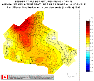
What a year it has been so far! Canada
has had it's warmest year since nationwide measurements began in 1948 with the temperature
2.4°C above normal. The next warmest year, 1981, was half a degree cooler.
These facts, along with global above normal temperature records for 1998 through November,
are further evidence that we are living in a warmer climate. Statistically, in an
unchanging climate, a year like this year could be expected only once every 1250
years. The map below shows that most of the country has experienced temperatures at
least 2°C above normal. The graph below shows just how outstanding 1998 has been,
as well as the linear trend for this period over the 51-year record at +0.8°C.
Over the past year, 6 months have set new warmest temperature records (February, April, May, July, August, September) and two months (June, and November) were second warmest. All 11 months have been warmer than normal.
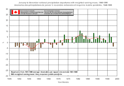
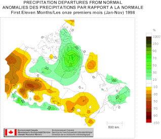
1998 has been a dry year, so far. Canada has had it's
9th driest year for the first 11 months, at 3.3% below normal. The map below shows
the drier than normal area extends from the Yukon south and east, covering most of British
Columbia, most of Alberta, the northern half of Saskatchewan, through the middle of
Manitoba, covering most of Ontario and continuing into the western edge of Quebec. Only
the Northwest Territories, along the 49th Parallel and the Maritimes have seen above
normal precipitation so far this year. The graph below shows in the last twenty
years, there have only been 2 years with below normal precipitation.
See what Environment Canada forecasts for the coming
seasons.
More information on La Nińa can be found at the Canadian La Nińa Bulletin.
Visit Environment Canada's Global Climate
Change Website.
Other summarized climate information can be found at the Canadian Institute for Climate Studies.
The American's National Climate Data Center publishes a similar bulletin for the US and
the Globe in Climate
Perspectives report.
[National Summary] [Regional Summary][CTVB Archive ][Français]
[The Green Lane][AES][CARD] ![]()
 |
Last modified : December 4,1998 URL of this page : http://www.tor.ec.gc.ca/ccrm/bulletin/index.html Copyright © 1998. All rights reserved |
| You are on the Green Lane™, Environment Canada's World Wide Web Site | |