19th Century History
Of Carleton's three major borders (river, canal and Bronson Avenue) one is of geological origin,
the other two are of cultural origin dating from 165-200 years ago.
More than thirty years passed with only a small population moving into the region,
none settling on lands now occupied by Carleton University. It was not until 1826,
when the British Royal Engineers were ordered to build a canal between the Ottawa
River and Lake Ontario, that notable cultural changes were made to the landscape.
 |  |
 | Watercolour representation of the site as viewed looking south
from Bronson Avenue at Canal. |
| © John Burrows, Archives of Ontario
|
The population of Nepean Township increased five-fold between 1827 and 1828.
Construction on the Rideau Canal caused considerable physical change to the neighbouring environment.
Tree cutting, excavating, dam building, and the unsanctioned occupying of habitable lands along the canal
right-of-way were commonplace.
The northeast half of the current campus site, a low-lying swamp, changed little during the 19th century.
Following canal construction the more habitable southwest half of the site, located on the higher ground,
was cleared, fenced and occupied by leaseholders, squatter families, and one land-owning farm family who
lived near the site of the present main quadrangle.
A lime kiln was located along the bank of the Rideau River below the current site of the Loeb Building.
In 1871 the St.Lawrence and Ottawa Railway built a line across the site to link their main tracks with
the emerging water-powered industries at the Chaudiere Falls. The current stone piers and the underpass
supports date from that period. A former swing bridge was located at Dow's Lake.
|
|
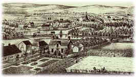 |
| Contemporary view of the site as viewed looking east from the location of today's Experimental Farm, 1879. |
| © H.Belden, Ottawa Public Library
|
A bywash, or canal overflow channel, was constructed from above the locks at Hartwell's in a
southeasterly direction to the river just below Stegmann's Falls, as it was then known.
Today overflow water passes underground.
One 19th century farmstead survived to the period when the first land was obtained at this
site by Carleton, located where the Stormont and Dundas residences are located. Foundations
of several former buildings were uncovered during construction of the new student residences.

