Land Use
 |
 |
 |
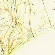
Map detail, 1926, revised 1946, shows an increase in small buildings along the Rideau River, including squatters' dwellings. |
| Dept of Mines and Resources
|
In spite of suburban development and Ottawa City limits reaching the eastern border of this site during the
first decade of the 20th century, the site itself was not developed further for five decades.
The canal road, running nearer to the waterway than present-day Colonel By Drive, served as the
only transportation link to the site until the 1950s. Water created barriers on the three sides
(the two railway bridges were cross-site links only), and the remains of Dow's Great Swamp served
as a major obstruction on the east perimeter. One third of the site was more than seven metres (23')
below the level of the surface of Dow's Lake, and less than two metres (6') above the lowest level of the river.
This large section of land was subject to frequent flooding.
At various times during the first half of the 20th century attempts to develop subdivisions on the site
failed because the physical barriers cut it off and hindered the township and municipality from providing
water and sewer services.
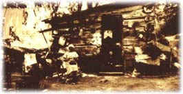 | |
| A squatter's home, believed to have been
located near the current site of the Loeb Building, c 1930 |
| NAC: PA-34285
|
As time passed it appears more of the agricultural land was used for pasture
or left fallow. As well, after the mid-1920s farmhouses were abandoned, orchards were not maintained,
and unauthorized squatter occupation increased along the high ground on the north bank of the river.

