
   |
|||||||
  |
E. R. Faribault (1855 - 1934) Lasting from 1882 until 1932, E.R. Faribault's career as a geologist was the longest in the history of the Geological Survey of Canada. His life's work was the systematic geological mapping of Nova Scotia. The series of maps produced by his teamwork with Hugh Fletcher was the GSC's most ambitious project to that point and continued until Faribault's retirement in 1933. Faribault and Fletcher published 70 map sheets with a scale of 1 inch = 1 mile (1 : 63,360), as well as many cross sections and detailed plans on scales as large as 1 inch = 500 ft (1 : 6000). These geological maps represent, in most cases, the first accurate delineation of many of the province's coalfields and continue to stand today as examles of excellence in field geology. In 1885, Faribault (who had been working under the direction of Fletcher) took on the
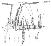
task of mapping Nova Scotia's gold fields. He concentrated
mostly on the intricate folds in the gold-bearing series of rocks along the southeast
coast of Nova Scotia known as the Meguma Group. Realising that the gold occurred like
saddles along the crests of small anticlines, he discovered many orebodies, most of which
were small. These discoveries were fundamental to our present understanding of the
location of gold in Nova Scotia. |
||||||
|
|||||||