Full Size = 68K
I caught a glimpse of Mt. Carmel on my first trip (one hundred miles from Rosthern to St. Peter's Monastery in the latter part of July, 1903. Some months later, in conversation with my superior, the Very Rec. Prior Alfred Mayer, O.S.B. I ventured to observe that perhaps some day coal and precious minerals would be discovered at the Mount. He replied that if I ever made such a find, he would see to it that a chapel in honor of Sr. John Chrysostom, my patron saint, would be erected there. I never did make such a discovery, but I was instrumental in buying the Mount for the Order of St. Benedict, Friday, August the twenty-second, 1921, from John Bunko, the homesteader. He donated half the purchase price of the Mount Comprising close to eleven acres, as his share towards launching this worthy undertaking of having a shrine to Christ's Holy Mother on the Mount, to have her honored by an annual pilgrimage. Witnesses of the transaction were Leo Woell, the driver of the car, and Ed Bruning, Justice of Peace, Both of Muenster. Ed and I did the measuring whilst Leo and John Bunko looked on and checked our figures.
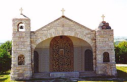
Most of those who settled the fifty townships which are under the spiritual guidance of St. Peter's Abbey, were invested in their childhood with the scapular of Our Lady of Mt. Carmel. Thus it was but natural that when they came within sight of Saskatchewan's Mount Carmel they should think "what a fine place for a shrine of Christ's Holy Mother! If we could make it into as holy a place as the Mount Carmel mentioned in the Bible!" This thought seems to have been in the mind of clergy and laity alike. The term of office of Prior Alfred expired in 1906, before the homesteaders were well-established on their land, or had all the religious schools they felt were needed. The second superior, Prior Bruno, later raised to the dignity of an Abbot, was hindered in the inauguration of a pilgrimage by the advent of the First World War. Finally the third superior, Abbot Michael Ott, O.S.B. was privileged to Solemnly dedicate it to Our Lady September 10, 1922, and to pontificate there in a small, shanty-like temporary chapel erected on top of the Mount. The present superior, Right Rev. Severin Gertken, O.S.B., M.S., was instrumental in the erection of large Statue of Christ's mother, a chapel and a large Way of the Cross.
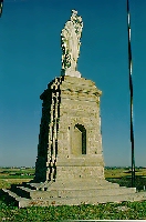
The statue is of white carrara marble, over eight feet in height. It was sculptured in Italy by one of its eminent artists. The pedestal is fourteen feet in height, and rests on a foundation of native stone. The statue was solemnly blessed in the presence of nearly nine thousand pilgrims, July 22, 1928. Lightning struck the pedestal of the statue on July 9, 1937, and again in 1950. In 1937 the damage was slight and easily repaired, but is was considerable in 1950.
There are many legends about the grave and suicide on Mount Carmel.
The Cross on the hill that all travellers mentioned, may have been placed there by some devout Metis, who thus wished to show his love for the Saviour and Redeemer. This is the highest point far and wide; nineteen hundred eighty-seven feet above sea level, or 95 feet higher than the Carmel railway station some miles to the south. Long ago, and for a good many years, the hill seems to have been bare of trees. The poplars I found there in 1921, were hardly mare than thirty of forty years old. This no doubt, was owing to prairie fires set by some lightening bolt, or by buffalo hunters to drive the animals into a trap.
The Dominion Land Surveyor, J. Lestock Reid, in 1886 in his report to the Surveyor General of Canada, says: "I surveyed the old road through the Touchwood Hills thence across the Salt Plain and past Humboldt and Mt. Carmel." He does not say he named it, but accepts a name already in use. Several writers use the name Big Hill. Among others, in the Geological Survey of Canada for 1873 - 74 there is an account by Alfred R. C. Selwyn in which he calls it Big Hill. He says "quite recently a substantial and conspicuous wooden cross has been erected on this hill by a travelling party of Roman Catholic missionaries." Another report credits a worthy bishop with having placed a cross on the hill when he had to spend Sunday at its foot. The last time a cross was placed on the hill was 1902 by F. J. Lange prospecting for Land for the Catholic Settlement Society.
September 26, 1948, the Mount received its crown of glory when the Holy Rosary Crusade was inaugurated there with at least ten thousand people making the pilgrimage.
[ Home ]
Please send comments to Carlton Trail REDA Inc.
![]()
[ The Humboldt Journal ][ Early Humboldt ]
[ St. Peter's Abbey | Agriculture | Communities ]
[ Present-day Humboldt and Surrounding Communities ]
[ Language ]
![]()